Journal of Applied Science Studies - Ozean Publications
Journal of Applied Science Studies - Ozean Publications
Journal of Applied Science Studies - Ozean Publications

Create successful ePaper yourself
Turn your PDF publications into a flip-book with our unique Google optimized e-Paper software.
N<br />
71000<br />
70000<br />
69000<br />
68000<br />
67000<br />
478000 479000 480000 481000 482000 483000 484000 485000 486000 487000<br />
Legend<br />
Country: Nigeria Date: 04/04/2007<br />
Scale :1:20000 Contour Inc.: 0.5<br />
0ft 2000ft 4000ft 6000ft 8000ft<br />
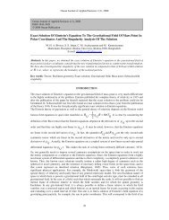
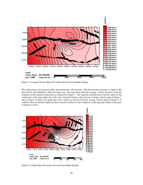
Figure 9. Average Velocity Map <strong>of</strong> B-surface derived from Simple Kriging.<br />
2206.0m/s<br />
2205.5m/s<br />
2205.0m/s<br />
2204.5m/s<br />
2204.0m/s<br />
2203.5m/s<br />
2203.0m/s<br />
2202.5m/s<br />
2202.0m/s<br />
2201.5m/s<br />
2201.0m/s<br />
2200.5m/s<br />
2200.0m/s<br />
2199.5m/s<br />
2199.0m/s<br />
2198.5m/s<br />
2198.0m/s<br />
2197.5m/s<br />
2197.0m/s<br />
2196.5m/s<br />
2196.0m/s<br />
2195.5m/s<br />
The nodal points were located within and outside the well locations. This has become necessary to improve the<br />
data density and reliability within the study area. The map shows that the average velocity increases from the<br />
northeast to the southwest directions as observed in Figure 7. The map also showed lower velocity values in the<br />
central part <strong>of</strong> the map where the wells were clustered similar to the previous average velocity map in Figure 7<br />
above. Figure 10 shows the depth map <strong>of</strong> B- surface as derived from the average velocity map in Figure 9. It<br />
could be observed that the depth increases from the northeast to the southwest <strong>of</strong> the map and similar in structure<br />
to Figures 5 and 8.<br />
N<br />
71000<br />
70000<br />
69000<br />
68000<br />
67000<br />
478000 479000 480000 481000 482000 483000 484000 485000 486000 487000<br />
Legend<br />
Country: Nigeria Date: 04/04/2007<br />
Scale :1:20000 Contour Inc.: 0.5<br />
0ft 2000ft 4000ft 6000ft 8000ft<br />
7010ft<br />
7005ft<br />
7000ft<br />
6995ft<br />
6990ft<br />
6985ft<br />
6980ft<br />
6975ft<br />
6970ft<br />
6965ft<br />
6960ft<br />
6955ft<br />
6950ft<br />
6945ft<br />
6940ft<br />
6935ft<br />
6930ft<br />
6925ft<br />
6920ft<br />
6915ft<br />
6910ft<br />
6905ft<br />
Figure 10. Depth Map <strong>of</strong> B surface derived from Simple Kriging<br />
86