1. INTRODUCTION
1. INTRODUCTION
1. INTRODUCTION

Create successful ePaper yourself
Turn your PDF publications into a flip-book with our unique Google optimized e-Paper software.
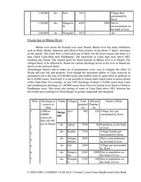
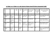
1,30,000 -do- Bori 1415 Village Bori<br />
surrounded by<br />
flood<br />
1,30,000 -do- Hangewa<br />
di<br />
4365 2000 Due to<br />
encroachments on<br />
the bank of river<br />
2,60,000 -do Wangdari 2473 -- -do-<br />
Floods due to Bhima River :<br />
Bhima river meets the Kukadi river near Daund. Bhima river has many tributaries<br />
such as Mula, Mutha, Indrayani and Ghod in Pune district. It has about 17 dams’ structures<br />
on the upside. The water flow is from each one of them. On the down stream side there is a<br />
dam called Ujani-Dam near Pandharpur. The backwater in Ujani dam rises above HFL<br />
resulting into floods. The control point for flood forecast in Bhima river is at Daund. The<br />
villages likely to be affected by floods for various discharge levels in the river at Daund are<br />
shown in the enclosed charts.<br />
Ahmednagar district had to make lot of preparations every year to mitigate the effect of<br />
floods and save life and property. Even though the maximum inflow in Ujani reservoir in<br />
estimated to be to the tune of 8,00,000 cusses and outflow from 41 gates from its spillway to<br />
the 6,34,000 cusses. Practically it is not possible to release there much water as down stream<br />
of the Ujani Dam. For example, in year 1997 discharge of about 2,75,000 cusses from Ujani<br />
and simultaneous discharge of 1,00,000 cusses from Nira river posed sever threat of flood to<br />
Pandharpur town. This result into storing of water in Ujani Dam above HFL between the<br />
free board area resulting it to flood danger in greater magnitude that designed.<br />
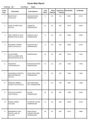
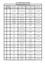
SrNo<br />
<strong>1.</strong><br />
2<br />
3<br />
4<br />
5<br />
6<br />
7<br />
Discharge in<br />
cussecs at<br />
Dam<br />
12000 to<br />
240000<br />
cusses net<br />
flow (II) 505<br />
mtr at Daund<br />
Taluka Villages Total<br />
populati<br />
on<br />
Shrigo<br />
nda<br />
Affected<br />
Populati<br />
on<br />
Nature of Risk<br />
Arvi 902 250 Village Arvi get<br />
surrounded by flood.<br />
-do- Ajjnuj 3930 60 Population on the bank<br />
of river.<br />
-do- Kauthe 2710 Village Kauthe get<br />
surrounded by flood.<br />
-do- Nimgao<br />
nKhalu<br />
2943 Due to encroachments<br />
on the bank of river<br />
-do Gar 1094 Village get surrounded<br />
by flood.<br />
-do- Hangew<br />
adi<br />
4365 2000 Due to population on<br />
the bank of river.<br />
-do-<br />
Wangda<br />
ri<br />
2743 100 Due to population on<br />
the bank of river.<br />
C:\DOCUME~1\ADMINI~1\LOCALS~1\Temp\C.Lotus.Notes.DataRevised Grain Bank
![216 - +ÃŪúÃä]äõ ĶÃŪúià ĶÃÃ>ðŪúÃÄ«Ã +ÃŪúÃä]äõ EÅÃÄÄ·ÃĪÃÃ](https://img.yumpu.com/36478022/1/184x260/216-aaaaaaau-aaaaia-aaaaaaaaa-aaaaaaau-eaaaaaaaa.jpg?quality=85)