JJ Nesbitt House - Kentucky: Heritage Council
JJ Nesbitt House - Kentucky: Heritage Council
JJ Nesbitt House - Kentucky: Heritage Council

You also want an ePaper? Increase the reach of your titles
YUMPU automatically turns print PDFs into web optimized ePapers that Google loves.
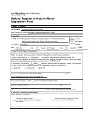
United States Department of the Interior<br />
National Park Service / National Register of Historic Places Registration Form<br />
NPS Form 10-900 OMB No. 1024-0018 (Expires 5/31/2012)<br />
<strong>Nesbitt</strong>, J.J., <strong>House</strong><br />
Name of Property<br />
Bath County, <strong>Kentucky</strong><br />
County and State<br />
1 17 257 429 4225 409 3<br />
Zone Easting Northing Zone Easting Northing<br />
2 4<br />
Zone Easting Northing Zone Easting Northing<br />
Verbal Boundary Description<br />
“Being and lying on the South side of West Main Street and beginning at a point in the center of West Main Street directly<br />
in line with the West boundary of the Alley known as Shady Line; thence running in a straight Southerly direction 205 feet<br />
along the line of Shady Lane to the Northeasterly corner of the Virginia Peed property line; thence running in a straight<br />
Westerly direction 75 feet along the Virginia Peed line to the Southeast corner of the Mrs. Ewell Shrout line to a point in<br />
the center of West Main Street; thence in a straight line along the center of West Main Street; thence in a straight line<br />
along the center of West Main Street 75 feet to the point of beginning and known as 233 West Main Street.”<br />
Boundary Justification<br />
The property proposed for inclusion on the National Register by the current nomination includes the .35 acre parcel<br />
associated with the J.J. <strong>Nesbitt</strong> <strong>House</strong>. This nominated property retains the historic dwelling constructed by J.J. <strong>Nesbitt</strong> in<br />
the Italianate style with later Revival modifications. The proposed boundaries provide an appropriate setting for<br />
understanding the significance of the design and construction of this house to the history of architecture of Bath County<br />
within both periods of significance. The boundary includes the domestic yard and maintains the historic setting in which<br />
the house was constructed.<br />
11. Form Prepared By<br />
name/title Janie-Rice Brother, Senior Architectural Historian<br />
organization <strong>Kentucky</strong> Archaeological Survey<br />
date<br />
street & number 1020A Export Street telephone 859-257-1944<br />
city or town Lexington state KY zip code 40506-9854<br />
e-mail janie-rice.brother@uky.edy<br />
Additional Documentation<br />
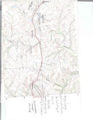
• Maps: A USGS map (7.5 or 15 minute series) indicating the property's location.<br />
• Additional items: Figures that consist in images of floor plans, comparative houses, and Sanborn Map plans.<br />
Photographs:<br />
Submit clear and descriptive photographs. The size of each image must be 1600x1200 pixels at 300 ppi (pixels per inch)<br />
or larger. Key all photographs to the sketch map.<br />
Name of Property:<br />
J.J. <strong>Nesbitt</strong> <strong>House</strong><br />
City or Vicinity: Owingsville<br />
23