Newry and Mourne District Council
Newry and Mourne District Council
Newry and Mourne District Council

You also want an ePaper? Increase the reach of your titles
YUMPU automatically turns print PDFs into web optimized ePapers that Google loves.
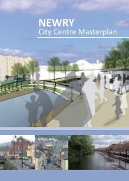
<strong>Newry</strong> City Centre Strategic Development Framework March 2004<br />
7. Central Canalside Redevelopment Zone<br />
While this has been identified as an opportunity site, it differs from the<br />
other sites in that it is not recommended that significant built<br />
development take place here. Instead, the opportunity should be<br />
grasped to remove the cars <strong>and</strong> the bus depot <strong>and</strong> create a pedestrian<br />
<strong>and</strong> cycling friendly space. That is not to say that one or two major<br />
buildings would be unsuitable. Such buildings should be “space defining<br />
buildings”, which create a civic space around them which may be<br />
suitable for events. The central area is the key to all future development in <strong>Newry</strong> city centre<br />
<strong>and</strong> it should be regarded as the central open space focus for the high density inner urban<br />
commercial development that will surround it.<br />
10. North Street Flats<br />
The important strong frontage that is defined by the buildings on<br />
Trevor Hill should be continued along North Street frontage of this<br />
site. The site would be suitable for redevelopment for office <strong>and</strong><br />
leisure/ entertainment use. Car parking should be a major part of the<br />
redevelopment in line with providing alternative car parking to Hill<br />
Street. It will be very important to establish good links to the primary<br />
retail core from the site. Any redevelopment would need to consider<br />
a link across the narrow part of Abbey Way directly into Margaret Street. This is an important<br />
axis through the city centre, which links to Monaghan Street. The main entrance to any future<br />
use of this site should be located here to provide a visual linkage from Monaghan Street.<br />
8. St Marys Street<br />
The buildings on the street are currently a barrier to any linkage from<br />
Buttercrane to the market. Redevelopment of the street should involve the<br />
construction of 3 storey buildings for residential use with ground floor retail.<br />
A link from the main access to the Buttercrane across the river <strong>and</strong> canal<br />
<strong>and</strong> connecting with the market <strong>and</strong> St Marys church should be promoted in<br />
conjunction with any redevelopment of this site. There may also be an<br />
opportunity to provide public access along the rear of these buildings<br />
9. Water Street/ Lower Water Street<br />
This site includes l<strong>and</strong> to the rear of Supervalu <strong>and</strong> the Cathedral <strong>and</strong><br />
is also bound by Abbey Way. It is a back l<strong>and</strong> site with a mix of flats<br />
development <strong>and</strong> a poorly laid out car park. This would be suitable<br />
location for a bus station which could be developed underneath a<br />
comprehensive development site that might include retailing, leisure<br />
<strong>and</strong> office uses. As with the North Street redevelopment, multi-storey car parking should be<br />
taken into consideration. Access to <strong>and</strong> views of the Cathedral would also need to be<br />
considered in any redevelopment scheme <strong>and</strong> a precinct set around the Cathedral to protect its<br />
setting.<br />
11. Abbey Playing Fields<br />
The development of Lidl, the proposed development around the<br />
Bagnals Castle site <strong>and</strong> the possible move of the Abbey Primary School<br />
has resulted in this site being considered as a possible opportunity site<br />
within the context of the city centre. In order to protect the retail<br />
importance of Hill Street <strong>and</strong> Monaghan Street, it is recommended that<br />
a policy be applied to this site restricting retail development. The development of the site should<br />
be in conjunction with the plans for Bagnals Castle. It would be suitable for office, leisure <strong>and</strong> car<br />
parking with some residential. Access to the site is rather restricted <strong>and</strong> should be via the<br />
Bagnals Castle site so as to prevent any further congestion on Courtney Hill. L<strong>and</strong> to the north<br />
of the Grammar School should be retained for open space/park.<br />
12. Health Centre<br />
Bounded by St Marys Street, John Mitchell Place <strong>and</strong> William Street, this<br />
site occupies a prominent gateway into the city centre, but its current<br />
use does not function as such. It will form an important physical <strong>and</strong><br />
visual link from the Quays <strong>and</strong> any future Albert Basin development<br />
directly into the southern end of the primary retail core. Any future use<br />
on this site should act as a “reception” building providing an attraction that will draw people into<br />
the primary retail core from the major uses around the Quays <strong>and</strong> Albert Basin. It may be<br />
appropriate to develop part of the site as a plaza tying in with the setting of the church to the<br />
north.<br />
Ferguson McIlveen in association with Mentor <strong>and</strong> Scott Wilson Page No. 21