User Guide - Digimap
User Guide - Digimap
User Guide - Digimap

You also want an ePaper? Increase the reach of your titles
YUMPU automatically turns print PDFs into web optimized ePapers that Google loves.
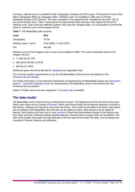
Currently, national cover is available for the Topography, Address and ITN Layers. The format for most of the<br />
data is Geography Mark-up Language (GML). Address Layer 2 is available in GML and in Comma<br />
Separated Values (CSV) formats. The data is supplied in the zipped format, indicated by the suffix ‘GZ’ at<br />
the end of the file name. Table 1 below gives the approximate data volumes in the zipped GZ format for<br />
national cover. Due to the way different systems may store the unzipped data, it is not possible to provide file<br />
sizes for national cover in the unzipped format.<br />
Table 1: OS MasterMap data volumes<br />
Layer<br />
Size<br />
Topography<br />
32 Gb<br />
Address Layer 1 and 2 2 Gb (GML) 1.4 Gb (CSV)<br />
ITN<br />
440 Mb<br />
National cover for the Imagery Layer is due to be available in 2006. The current estimated sizes for the<br />
images only are:<br />
• 11 300 Gb for TIFF<br />
• 360 Gb for Mr SID or ECW<br />
• 660 Gb for JPEG<br />
Additional space should be allowed for metadata and registration files.<br />
The minimum system requirements to use the OS MasterMap online service are detailed on the<br />
Ordnance Survey website.<br />
For further information on the technical implications of implementing OS MasterMap please see Information<br />
sheet 3 – Technical implications from the implementing OS MasterMap series of documents from the<br />
Ordnance Survey website.<br />
Gaelic or Welsh names are also supported. A character set is available.<br />
The data model<br />
OS MasterMap vector products have a hierarchical structure. The highest level of the structure is the layer.<br />
Within each layer can be a series of themes. Within each theme there will be features deemed to belong to<br />
that theme. A feature can belong to more than one theme. This model is extensible at all levels. New layers<br />
can be added to OS MasterMap. New themes can be added to layers. New features can be added to<br />
themes. Each feature will have one or more versions of itself that demonstrate change to that feature over<br />
time. New versions of features replace existing features. Features that no longer exist can be deleted. The<br />
rest of this chapter discusses the main features of the first level of the model, the layer, and introduces the<br />
concepts of themes, features and attributes.<br />
OS MasterMap Topography Layer user guide chapter 1 v1.3 – 07/2007 © Crown copyright Page 10 of 140