User Guide - Digimap
User Guide - Digimap
User Guide - Digimap

Create successful ePaper yourself
Turn your PDF publications into a flip-book with our unique Google optimized e-Paper software.
Chapter 2<br />
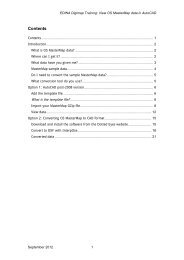
Introduction to OS MasterMap Topography Layer<br />
The OS MasterMap Topography Layer contains features that represent objects in the physical environment<br />
such as buildings, fields, fences and letter boxes, as well as intangible objects such as county boundaries or<br />
the line of mean high water. There are over 450 million features in the current product. It is available for all of<br />
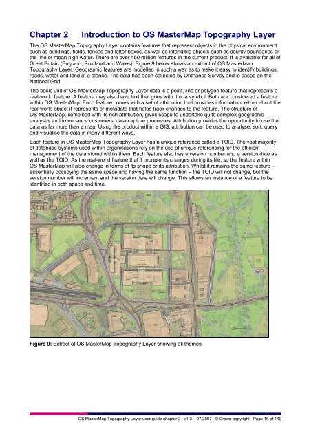
Great Britain (England, Scotland and Wales). Figure 9 below shows an extract of OS MasterMap<br />
Topography Layer. Geographic features are modelled in such a way as to make it easy to identify buildings,<br />
roads, water and land at a glance. The data has been collected by Ordnance Survey and is based on the<br />
National Grid.<br />
The basic unit of OS MasterMap Topography Layer data is a point, line or polygon feature that represents a<br />
real-world feature. A feature may also have text that goes with it or a symbol. Both are considered a feature<br />
within OS MasterMap. Each feature comes with a set of attribution that provides information, either about the<br />
real-world object it represents or metadata that helps track changes to the feature. The structure of<br />
OS MasterMap, combined with its rich attribution, gives scope to undertake quite complex geographic<br />
analyses and to enhance customers’ data-capture processes. Attribution provides the opportunity to use the<br />
data as far more than a map. Using the product within a GIS, attribution can be used to analyse, sort, query<br />
and visualise the data in many different ways.<br />
Each feature in OS MasterMap Topography Layer has a unique reference called a TOID. The vast majority<br />
of database systems used within organisations rely on the use of unique referencing for the efficient<br />
management of the data stored within them. Each feature also has a version number and a version date as<br />
well as the TOID. As the real-world feature that it represents changes during its life, so the feature within<br />
OS MasterMap will also change in terms of its shape or its attribution. Whilst it remains the same feature –<br />
essentially occupying the same space and having the same function – the TOID will not change, but the<br />
version number will increment and the version date will change. This allows an instance of a feature to be<br />
identified in both space and time.<br />
Figure 9: Extract of OS MasterMap Topography Layer showing all themes<br />
OS MasterMap Topography Layer user guide chapter 2 v1.3 – 07/2007 © Crown copyright Page 16 of 140