User Guide - Digimap
User Guide - Digimap
User Guide - Digimap

Create successful ePaper yourself
Turn your PDF publications into a flip-book with our unique Google optimized e-Paper software.
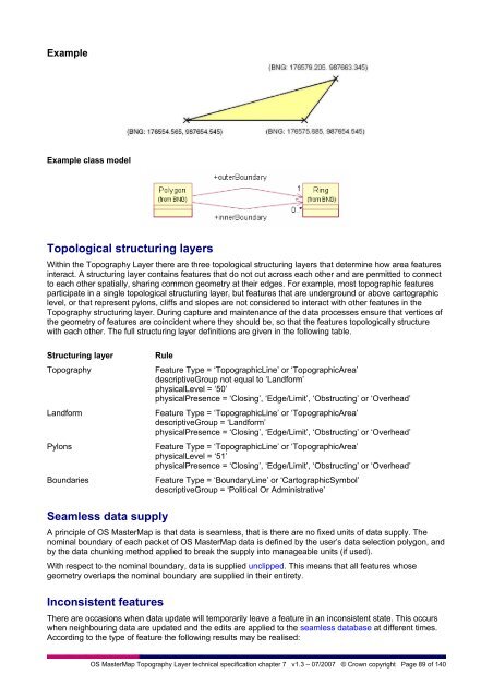
Example<br />
Example class model<br />
Topological structuring layers<br />
Within the Topography Layer there are three topological structuring layers that determine how area features<br />
interact. A structuring layer contains features that do not cut across each other and are permitted to connect<br />
to each other spatially, sharing common geometry at their edges. For example, most topographic features<br />
participate in a single topological structuring layer, but features that are underground or above cartographic<br />
level, or that represent pylons, cliffs and slopes are not considered to interact with other features in the<br />
Topography structuring layer. During capture and maintenance of the data processes ensure that vertices of<br />
the geometry of features are coincident where they should be, so that the features topologically structure<br />
with each other. The full structuring layer definitions are given in the following table.<br />
Structuring layer<br />
Topography<br />
Landform<br />
Pylons<br />
Boundaries<br />
Rule<br />
Feature Type = ‘TopographicLine’ or ‘TopographicArea’<br />
descriptiveGroup not equal to ‘Landform’<br />
physicalLevel = ‘50’<br />
physicalPresence = ‘Closing’, ‘Edge/Limit’, ‘Obstructing’ or ‘Overhead’<br />
Feature Type = ‘TopographicLine’ or ‘TopographicArea’<br />
descriptiveGroup = ‘Landform’<br />
physicalPresence = ‘Closing’, ‘Edge/Limit’, ‘Obstructing’ or ‘Overhead’<br />
Feature Type = ‘TopographicLine’ or ‘TopographicArea’<br />
physicalLevel = ‘51’<br />
physicalPresence = ‘Closing’, ‘Edge/Limit’, ‘Obstructing’ or ‘Overhead’<br />
Feature Type = ‘BoundaryLine’ or ‘CartographicSymbol’<br />
descriptiveGroup = ‘Political Or Administrative’<br />
Seamless data supply<br />
A principle of OS MasterMap is that data is seamless, that is there are no fixed units of data supply. The<br />
nominal boundary of each packet of OS MasterMap data is defined by the user’s data selection polygon, and<br />
by the data chunking method applied to break the supply into manageable units (if used).<br />
With respect to the nominal boundary, data is supplied unclipped. This means that all features whose<br />
geometry overlaps the nominal boundary are supplied in their entirety.<br />
Inconsistent features<br />
There are occasions when data update will temporarily leave a feature in an inconsistent state. This occurs<br />
when neighbouring data are updated and the edits are applied to the seamless database at different times.<br />
According to the type of feature the following results may be realised:<br />
OS MasterMap Topography Layer technical specification chapter 7 v1.3 – 07/2007 © Crown copyright Page 89 of 140