- Page 2 and 3: OS MasterMap Topography Layer User
- Page 4 and 5: Preface This user guide (hereafter
- Page 6 and 7: Chapter 1 Introduction to OS Master
- Page 8 and 9: The vector and raster data models T
- Page 10 and 11: Currently, national cover is availa
- Page 14 and 15: Imagery Layer The Imagery Layer com
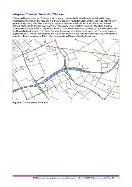
- Page 16 and 17: Chapter 2 Introduction to OS Master
- Page 18 and 19: It is important for many applicatio
- Page 20 and 21: Chapter 3 Feature life cycles and t
- Page 22 and 23: One of the key differences between
- Page 24 and 25: Joining of polygon features When tw
- Page 26 and 27: The other type is a polygon closing
- Page 28 and 29: Chapter 4 OS MasterMap Topography L
- Page 30 and 31: A textual description is used for c
- Page 32 and 33: Rail These are defined as features
- Page 34 and 35: There are two situations where cons
- Page 36 and 37: Figure 17 shows a sample of real-wo
- Page 38 and 39: Table 3 Value of descriptive group
- Page 40 and 41: This chapter has discussed the them
- Page 42 and 43: Table 4: Attribution by feature typ
- Page 44 and 45: Physical level The physical level a
- Page 46 and 47: Text string Cartographic text that
- Page 48 and 49: The advantages of supplying COU rat
- Page 50 and 51: Supply of OS MasterMap Topography L
- Page 52 and 53: Departed features are supplied in C
- Page 54 and 55: Chapter 7 Change management and dat
- Page 56 and 57: This is a more efficient way of sto
- Page 58 and 59: Figure 28: Styling options with OS
- Page 60 and 61: Annexe A Administrative boundary al
- Page 62 and 63:
OS MasterMap Topography Layer Techn
- Page 64 and 65:
Symbols ...........................
- Page 66 and 67:
Chapter 1 Key concepts This section
- Page 68 and 69:
Chapter 3 Theme definitions This ch
- Page 70 and 71:
Chapter 4 Feature attribution In OS
- Page 72 and 73:
CartographicSymbol Attribute Occurr
- Page 74 and 75:
Simple attribute name Type Descript
- Page 76 and 77:
Simple attribute name Type Descript
- Page 78 and 79:
Chapter 6 Attribute values Attribut
- Page 80 and 81:
The following table clarifies the u
- Page 82 and 83:
Descriptive group Feature type Desc
- Page 84 and 85:
Make Descriptive group Feature type
- Page 86 and 87:
Chapter 7 Geometry and topology Int
- Page 88 and 89:
Example class model Rectangle A rec
- Page 90 and 91:
Polygon boundary duplication A brea
- Page 92 and 93:
Chapter 9 GML output format The OS
- Page 94 and 95:
For geographically chunked data, if
- Page 96 and 97:
For example: 12365.563,8975.676
- Page 98 and 99:
Schema descriptions The W3C-provide
- Page 100 and 101:
descriptiveGroup descriptiveTerm ma
- Page 102 and 103:
Property application logic This sec
- Page 104 and 105:
Chapter 11 Data supply service The
- Page 106 and 107:
Annexe A Glossary The purpose of th
- Page 108 and 109:
georectified imagery The georectifi
- Page 110 and 111:
orthorectified imagery The Imagery
- Page 112 and 113:
Annexe B GML examples 1 A typical T
- Page 114 and 115:
Annexe C Cartographic style definit
- Page 116 and 117:
Fonts The gml2svg.xsl declares the
- Page 118 and 119:
Geometry: boundaryMereingChangeSy
- Page 120 and 121:
triangulationStationSymbol Style: s
- Page 122 and 123:
multiVegetationFillSymbol Style: st
- Page 124 and 125:
screeFillSymbol Style: stroke:#6666
- Page 126 and 127:
smallNonconiferousTreeFillSymbol St
- Page 128 and 129:
Definitions Transformation 1 Symbol
- Page 130 and 131:
Name: roughGrassAndMarshFillSymbol
- Page 132 and 133:
Name: roughGrassScatteredRocksAndHe
- Page 134 and 135:
nonconiferousTreesAndScrubPattern r
- Page 136 and 137:
Water bold Name - waterBoldLine str
- Page 138 and 139:
Parliamentary Name - parliamentaryL
- Page 140:
Acute accent on the following (for