User Guide - Digimap
User Guide - Digimap
User Guide - Digimap

Create successful ePaper yourself
Turn your PDF publications into a flip-book with our unique Google optimized e-Paper software.
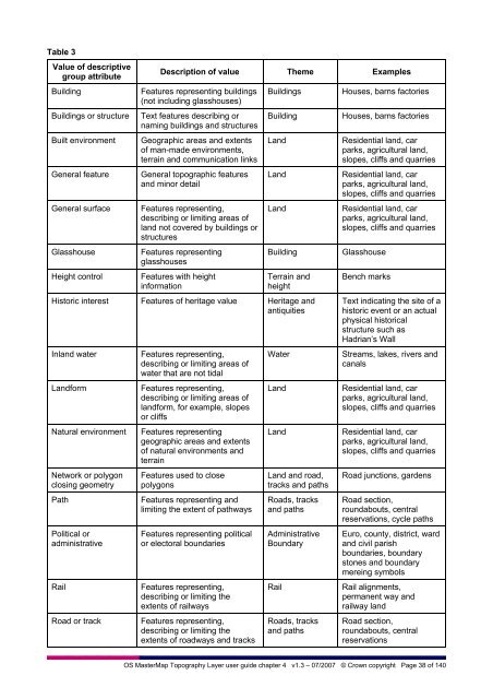
Table 3<br />
Value of descriptive<br />
group attribute<br />
Building<br />
Buildings or structure<br />
Built environment<br />
General feature<br />
General surface<br />
Glasshouse<br />
Height control<br />
Description of value Theme Examples<br />
Features representing buildings<br />
(not including glasshouses)<br />
Text features describing or<br />
naming buildings and structures<br />
Geographic areas and extents<br />
of man-made environments,<br />
terrain and communication links<br />
General topographic features<br />
and minor detail<br />
Features representing,<br />
describing or limiting areas of<br />
land not covered by buildings or<br />
structures<br />
Features representing<br />
glasshouses<br />
Features with height<br />
information<br />
Buildings<br />
Building<br />
Land<br />
Land<br />
Land<br />
Building<br />
Terrain and<br />
height<br />
Historic interest Features of heritage value Heritage and<br />
antiquities<br />
Inland water<br />
Landform<br />
Natural environment<br />
Network or polygon<br />
closing geometry<br />
Path<br />
Political or<br />
administrative<br />
Rail<br />
Road or track<br />
Features representing,<br />
describing or limiting areas of<br />
water that are not tidal<br />
Features representing,<br />
describing or limiting areas of<br />
landform, for example, slopes<br />
or cliffs<br />
Features representing<br />
geographic areas and extents<br />
of natural environments and<br />
terrain<br />
Features used to close<br />
polygons<br />
Features representing and<br />
limiting the extent of pathways<br />
Features representing political<br />
or electoral boundaries<br />
Features representing,<br />
describing or limiting the<br />
extents of railways<br />
Features representing,<br />
describing or limiting the<br />
extents of roadways and tracks<br />
Water<br />
Land<br />
Land<br />
Land and road,<br />
tracks and paths<br />
Roads, tracks<br />
and paths<br />
Administrative<br />
Boundary<br />
Rail<br />
Roads, tracks<br />
and paths<br />
Houses, barns factories<br />
Houses, barns factories<br />
Residential land, car<br />
parks, agricultural land,<br />
slopes, cliffs and quarries<br />
Residential land, car<br />
parks, agricultural land,<br />
slopes, cliffs and quarries<br />
Residential land, car<br />
parks, agricultural land,<br />
slopes, cliffs and quarries<br />
Glasshouse<br />
Bench marks<br />
Text indicating the site of a<br />
historic event or an actual<br />
physical historical<br />
structure such as<br />
Hadrian’s Wall<br />
Streams, lakes, rivers and<br />
canals<br />
Residential land, car<br />
parks, agricultural land,<br />
slopes, cliffs and quarries<br />
Residential land, car<br />
parks, agricultural land,<br />
slopes, cliffs and quarries<br />
Road junctions, gardens<br />
Road section,<br />
roundabouts, central<br />
reservations, cycle paths<br />
Euro, county, district, ward<br />
and civil parish<br />
boundaries, boundary<br />
stones and boundary<br />
mereing symbols<br />
Rail alignments,<br />
permanent way and<br />
railway land<br />
Road section,<br />
roundabouts, central<br />
reservations<br />
OS MasterMap Topography Layer user guide chapter 4 v1.3 – 07/2007 © Crown copyright Page 38 of 140