User Guide - Digimap
User Guide - Digimap
User Guide - Digimap

Create successful ePaper yourself
Turn your PDF publications into a flip-book with our unique Google optimized e-Paper software.
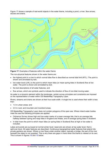
Figure 17 shows a sample of real-world objects in the water theme, including a pond, a river, flow arrows,<br />
sluices and drains.<br />
Figure 17: Examples of features within the water theme<br />
The non-physical features shown in the water theme are:<br />
• the highest point in a river to which normal tides flow is described as normal tidal limit (NTL). The point is<br />
shown and annotated by text;<br />
• low water level (LWL) is the point to which mean tides (or mean spring tides in Scotland) flow at low<br />
water. The point is shown and annotated by text;<br />
• the text descriptions of all water features; and<br />
• flow arrows, which are symbols used to indicate the direction of flow of non-tidal moving water.<br />
As water is a dynamic element within the landscape, certain survey principles and constraints are imposed<br />
on the representation of water within OS MasterMap Topography Layer.<br />
Rivers, streams and drains are shown at their true scale width. A single line is used where their width is less<br />
than:<br />
• 1.0 m urban areas; and<br />
• 2.0 m rural, and mountain and moorland areas.<br />
OS MasterMap Topography Layer does not contain polygons of the open sea. Where inland water bodies<br />
meet the sea the following principles are applied:<br />
• Ordnance Survey shows high and low water marks of a mean average tide, that is an average tide<br />
halfway between spring and neap tides in England and Wales, and of average spring tides in Scotland.<br />
• In tidal rivers the point to which mean tides (or spring tides in Scotland) flow at high or low water is<br />
included.<br />
Lakes and ponds are surveyed at normal winter level; reservoirs are shown at top water level, that is<br />
spill-over level. All water features are described. Continuous topographical water features that extend into<br />
private gardens are shown. Where a river flows under another object, typically a bridge, the part of the river<br />
beneath the object is not supplied. This is why there are gaps in rivers when the theme is viewed on its own.<br />
This is shown in figures 18 and 19 below.<br />
OS MasterMap Topography Layer user guide chapter 4 v1.3 – 07/2007 © Crown copyright Page 36 of 140