Full version, lower resolution, 3.25MB - InterRidge
Full version, lower resolution, 3.25MB - InterRidge
Full version, lower resolution, 3.25MB - InterRidge

You also want an ePaper? Increase the reach of your titles
YUMPU automatically turns print PDFs into web optimized ePapers that Google loves.
International Research<br />
R/V Celtic Explorer cruise to survey and sample the V-shaped ridges, south of<br />
Iceland: testing the heartbeat of the Iceland Plume<br />
Bramley Murton 1 , Stephen Jones 2 , Gavin Elliot 1 , Stephanie Ingles 1 , Godfrey Fitton 3 , and Nicholas White 4<br />
V-Shaped Ridges (VSRs), developed in oceanic crust to the<br />
south of Iceland (Fig. 1), are the world’s best window into the<br />
time-dependent dynamics of mantle convection (Vogt 1971,<br />
1974, 1979; Vogt and Avery 1974). It is generally agreed that<br />
VSRs result from melting anomalies that propagate outward<br />
from Iceland, but the cause of the melting anomalies and what<br />
drives the mantle flow that carries them are debated. From<br />
their geometry, the VSRs appear to derive from perturbations<br />
in mantle melting that advect away from Iceland at a rate of<br />
20 cm per year (Murton and Parson 1993; Jones et al. 2002).<br />
This astonishing velocity is 10 times faster than the adjacent<br />
mid-ocean ridge spreading rate, and the fluctuations in melting<br />
have affected the adjacent continental margins and deep<br />
ocean circulation throughout the Eocene. Previous work in<br />
this region, which acquired detailed bathymetry and collected<br />
and analysed basalt samples from the Reykjanes Ridge, concluded<br />
that the VSRs were the result of anomalous regions of<br />
southward advecting asthenosphere that yield higher degrees of<br />
mantle melting (Taylor et al. 1995, 1997; Murton et al. 2002).<br />
The new survey, on board the Irish research ship R/V Celtic Explorer<br />
with PIs SJ and BM, acquired essential bathymetric data<br />
and volcanic samples of the VSRs. These will be used to answer<br />
questions about temporal variation in mantle convection. They<br />
will also contribute to site survey data in support of IODP proposal<br />
646-<strong>Full</strong> (lead PI BM; proposal summary available at:<br />
http://www.interridge.org/files/interridge/646-<strong>Full</strong>_Cover[1].<br />
pdf). The survey, on cruise CE008 from 20 April - 16 May<br />
2008, covered one of the VSRs (VSR2W) developed in oceanic<br />
crust south of Iceland.<br />
We collected a total of 80 new samples from 33 dredge stations<br />
and bathymetrically surveyed the entire strike of VSR2W<br />
using the portable multibeam echosounder system ‘RESON<br />
SeaBat 8160’ (Fig. 2). These new data are the first to have been<br />
collected from the off-axis VSRs since the first reflection seismic<br />
survey that lead to discovery of the VSRs in the 1960s.<br />
Initial results show that the VSRs are the result of thermal and<br />
compositional fluctuations that propagate out from Iceland at a<br />
rate of up to 20 cm per year over a distance of 1000 km. These<br />
fluctuations are wholly compatible with an origin within an<br />
upwelling mantle plume beneath Iceland, where composition<br />
and temperature appear to be intrinsically linked, and which<br />
is deflected southwards along the Reykjanes Ridge. Further<br />
isotopic and trace element analyses are underway which, by<br />
comparison with the Reykjanes Ridge geochemical data, will<br />
be used to test hypotheses for the geometry of the wedge of<br />
asthenospheric mantle as it advects away from Iceland.<br />
Acknowledgements<br />
Other seagoing scientists and students involved with cruise<br />
CE008 include: Garath Roberts and Sarah Nixon (Cambridge),<br />
Janine Guinan, (Marine Institute, Ireland), Samantha<br />
Unsworth (NOCS), Cora McKenna (University College,<br />
Cork), and Zara Archibald and Catherine Breheny (National<br />
University of Ireland, Galway). The work was only possible due<br />
to the dedication of the crew and officers of the R/V Celtic<br />
Explorer who managed to cope with adverse and, at times, extreme<br />
North Atlantic weather conditions (Fig. 3). We are also<br />
indebted to John Davis and Tim LeBas (NOC) and Danny<br />
Wake (Reson Offshore Ltd.) for assistance in the initial Reson<br />
set-up. Ship time and logistical support was granted to SJ<br />
by the Science Foundation, Ireland and the Marine Institute,<br />
Ireland. Support for the Reson multibeam echosounder<br />
and dredging was granted to BM and GE from a UK-IODP<br />
grant (NE/G001251/1), titled “Site Survey for IODP Proposal<br />
646-<strong>Full</strong>: Icelandic V-Shaped-Ridges.”<br />
References<br />
Jones, S.M., N. White, & J. Maclennan, V-shaped ridges<br />
around Iceland: implications for spatial and temporal pat-<br />
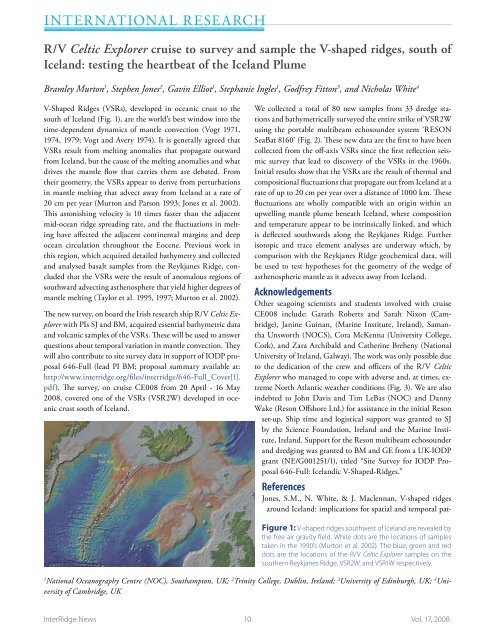
Figure 1: V-shaped ridges southwest of Iceland are revealed by<br />
the free air gravity field. White dots are the locations of samples<br />
taken in the 1990’s (Murton et al. 2002). The blue, green and red<br />
dots are the locations of the R/V Celtic Explorer samples on the<br />
southern Reykjanes Ridge, VSR2W, and VSR1W respectively.<br />
1<br />
National Oceanography Centre (NOC), Southampton, UK; 2 Trinity College, Dublin, Ireland; 3 University of Edinburgh, UK; 4 University<br />
of Cambridge, UK<br />
<strong>InterRidge</strong> News 10 Vol. 17, 2008