Full version, lower resolution, 3.25MB - InterRidge
Full version, lower resolution, 3.25MB - InterRidge
Full version, lower resolution, 3.25MB - InterRidge

You also want an ePaper? Increase the reach of your titles
YUMPU automatically turns print PDFs into web optimized ePapers that Google loves.
International Research<br />
big pillows. The thickness of the sedimentary layers is estimated<br />
to be ~0.5-2 m from the sub-bottom profiler measurement.<br />
The thickest sedimentary layers among our dives are observed<br />
in this portion.<br />
The submersible climbed a very steep slope of 60-70° of the<br />
hummocky ridge of elongate and knobby pillows directing<br />
downslope with a thin sedimentary carapace. The summit of<br />
the hummocky ridge is cut by faults running NNE and NNW,<br />
which expose truncated pillow lobes.<br />
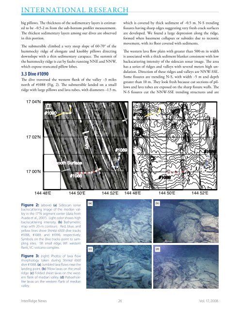
3.3 Dive #1090<br />
The dive traversed the western flank of the valley ~3 miles<br />
north of #1088 (Fig. 2). The submersible landed on a small<br />
ridge with large pillows and lava tubes, with diameters ~1.5 m,<br />
which is covered by thick sediment of ~0.5 m. N-S trending<br />
fissures having sharp edges suggesting very fresh crack surfaces<br />
are developed. We found a large depression along the ridge,<br />
formed when basement collapses or subsides due to tectonic<br />
movement, with its floor covered with sediments.<br />
The western lava flow plain with greater than 500-m in width<br />
is associated with a thick sediment blanket consistent with low<br />
backscattering intensity of the sidescan sonar image. The area<br />
has a series of ridges and valleys with several meters high undulation.<br />
Direction of these ridges and valleys are NNW-SSE.<br />
Some fissures are trending N-S, with width ~5 m and depth<br />
greater than 10 m. They look fresh because cut sections of pillows<br />
and lava tubes are exposed on the sharp fissure walls. The<br />
N-S fissures cut the NNW-SSE trending structures and are<br />
17 04'N<br />
(a)<br />
#1090<br />
(b)<br />
#1090<br />
-3800<br />
-3700<br />
WF<br />
SR<br />
-3700<br />
-3600<br />
17 02'N<br />
-3600<br />
-3600<br />
Eastern Margin<br />
-3400<br />
Bumpy<br />
#1089<br />
-3400<br />
#1089<br />
Western Margin<br />
17 00'N<br />
Smooth Surface<br />
#1088<br />
-3500<br />
#1088<br />
WF<br />
-3400<br />
SR<br />
-3400<br />
VC<br />
-3500<br />
144 48'E 144 50'E 144 52'E<br />
144 48'E 144 50'E 144 52'E<br />
Figure 2: (above) (a) Sidescan sonar<br />
backscattering image of the median valley<br />
in the 17°N segment center (data from<br />
Asada et al., 2007). Light color shows high<br />
backscattering intensity. (b) Bathymetric<br />
map with 20-m contours. Red, blue, and<br />
yellow lines show Shinkai 6500 dive tracks<br />
#1088, #1089, and #1090, respectively.<br />
Symbols on the dive tracks point to sampling<br />
sites. SR: small ridge, WF: western<br />
flank, VC: volcano complex.<br />
(a)<br />
(c)<br />
(b)<br />
(d)<br />
Fujiwara et al. Figure 2<br />
Figure 3: (right) Photos of lava flow<br />
morphology taken during Shinkai 6500<br />
dive #1088. (a) Jumbled lava flows near the<br />
landing point. (b) Pillow lavas on the small<br />
ridge. (c) Folded sheet lavas on the western<br />
flank of median valley. (d) Pahoehoelike<br />
lavas on the western flank of median<br />
valley.<br />
<strong>InterRidge</strong> News 26 Vol. 17, 2008