Full version, lower resolution, 3.25MB - InterRidge
Full version, lower resolution, 3.25MB - InterRidge
Full version, lower resolution, 3.25MB - InterRidge

You also want an ePaper? Increase the reach of your titles
YUMPU automatically turns print PDFs into web optimized ePapers that Google loves.
National News<br />
Philippines:<br />
Investigations of the oceanic lithospheric fragments in Mindoro:<br />
Clues to the arc - continent collision in Central Philippines<br />
G.P. Yumul Jr. 1,2 , C.B. Dimalanta 1 , K.L. Queaño 3 , E.J. Marquez 4 , R.A. Tamayo Jr. 1 , F.T. Jumawan 1 , L.T.<br />
Armada 1 , J.A.S. Gabo 1 , R.D.O. Mediavillo 1 , D.E.L. Riguer 1 and C.D.U. Carranza 1<br />
In 2003 researchers from the National Institute of Geological<br />
Sciences, University of the Philippines, and the Mines and<br />
Geosciences Bureau with support from the Department of Science<br />
and Technology began a campaign to investigate the arccontinent<br />
collision in west Central Philippines. The Palawan<br />
microcontinental block, a fragment rifted from the southern<br />
margin of mainland Asia, collided with the Philippine Mobile<br />
Belt during the Early to Middle Miocene. As a result, various<br />
features believed to have been produced by the collision event<br />
were preserved and can be observed in Palawan, Romblon Island<br />
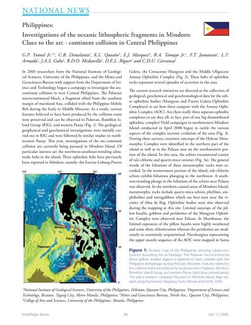
Group (RIG), and western Panay (Fig. 1). The geological,<br />
geophysical and geochemical investigations were initially carried<br />
out in RIG and were followed by similar studies in northwestern<br />
Panay. This year, investigations of the arc-continent<br />
collision are currently being pursued in Mindoro Island. Of<br />
particular interest are the northwest-southeast-trending ultramafic<br />
belts in the island. Three ophiolitic belts have previously<br />
been reported in Mindoro, namely: the Eocene Lubang-Puerto<br />
Galera, the Cretaceous Mangyan and the Middle Oligocene<br />
Amnay Ophiolitic Complex (Fig. 2). These belts of ophiolitic<br />
rocks represent several episodes of accretion in the area.<br />
The current research initiatives are directed at the collection of<br />
geological, geochemical and geochronological data for the other<br />
ophiolitic bodies (Mangyan and Puerto Galera Ophiolitic<br />
Complexes) to see how these compare with the Amnay Ophiolitic<br />
Complex (AOC). Are there really three separate ophiolite<br />
complexes or are they all, in fact, part of one big dismembered<br />
ophiolitic complex? Field campaigns in northwestern Mindoro<br />
Island conducted in April 2008 began to tackle the various<br />
aspects of the complex tectonic evolution of the area (Fig. 3).<br />
During these surveys, extensive outcrops of the Halcon Metamorphic<br />
Complex were identified in the northern part of the<br />
island as well as in the Paluan area on the northwestern portion<br />
of the island. In this area, the schists encountered consist<br />
of talc-chlorite and quartz-mica varieties (Fig. 3a). The general<br />
trends of the foliations of these metamorphic rocks were recorded.<br />
In the westernmost portion of the island, talc-chlorite<br />
schists exhibit foliations plunging to the northwest. A southeast-trending<br />
plunge in the foliations of the schists near Paluan<br />
was observed. In the northern coastal areas of Mindoro Island,<br />
metamorphic rocks include quartz-mica schists, phyllites, amphibolites<br />
and metagabbros which are best seen near the vicinity<br />
of Abra de Ilog. Ophiolitic bodies were also observed<br />
during the mapping at this site. Limited outcrops of the pillow<br />
basalts, gabbros and peridotites of the Mangyan Ophiolitic<br />
Complex were observed near Paluan. In Mamburao, the<br />
limited exposures of the pillow basalts were highly weathered<br />
and some show chloritization whereas the peridotites are moderately<br />
to extensively serpentinized. Harzburgites representing<br />
the upper mantle sequence of the AOC were mapped in Santa<br />
Figure 1: Tectonic map of the Philippines showing subduction<br />
systems bounding the archipelago. The Palawan microcontinental<br />
block (yellow shaded region) is believed to have collided with the<br />
Philippine archipelago during the Early Miocene. Features related to<br />
the collision event are believed to be preserved in Palawan, Mindoro,<br />
Romblon Island Group, and western Panay (light blue colored areas).<br />
This year’s research campaign focused on Mindoro Island. Map created<br />
using the Generic Mapping Tools (Wessel and Smith, 1995).<br />
1<br />
National Institute of Geological Sciences, University of the Philippines, Diliman, Quezon City, Philippines; 2 Department of Science and<br />
Technology, Bicutan, Taguig City, Metro Manila, Philippines; 3 Mines and Geosciences Bureau, North Ave., Quezon City, Philippines;<br />
4<br />
College of Arts and Sciences, University of the Philippines, Manila, Philippines<br />
<strong>InterRidge</strong> News 38 Vol. 17, 2008