Full version, lower resolution, 3.25MB - InterRidge
Full version, lower resolution, 3.25MB - InterRidge
Full version, lower resolution, 3.25MB - InterRidge

You also want an ePaper? Increase the reach of your titles
YUMPU automatically turns print PDFs into web optimized ePapers that Google loves.
International Research<br />
The slow ship speed and closely spaced tracks resulted in a large<br />
degree of over-sampling with the multibeam, and enabled us<br />
to produce a gridded Digital Terrain Model (DTM) with a<br />
horizontal <strong>resolution</strong> of ~50 m (Fig. 1).<br />
TOBI position was initially estimated from a combination of<br />
vehicle depth and tow-cable length using a dynamic tow-cable<br />
simulation, and sidescan mosaics were prepared using PRISM<br />
software (Le Bas, 2005). The sidescan and bathymetry were<br />
then compared, and positions of salient features were found to<br />
agree to within 500 m or less. Control points were then manually<br />
selected by visually matching common features in the two<br />
datasets, and used to produce a corrected TOBI track. Subsequently,<br />
GPS/USBL-navigated Isis bathymetry was compared,<br />
and positions of the re-navigated sidescan were found to agree<br />
with the Isis bathymetry to within a few tens of metres.<br />
TOBI total magnetic field data were inverted with bathymetry<br />
to produce crustal magnetisation maps (Parker and Huestis,<br />
1974; Guspi, 1987). Since magnetic palaeointensity increased<br />
approximately monotonically from ~45 ka to ~3 ka (McElhinny<br />
and McFadden, 2000), we took crustal magnetisation as an<br />
approximate proxy for age and used the magnetisation map to<br />
help target Isis dives. The map showed high magnetisation in<br />
the southern half of the AVR (which is also slightly shal<strong>lower</strong><br />
overall), particularly near its southern tip; there was also a high<br />
magnetisation area on the median valley (MV) floor to the NE<br />
of the AVR.<br />
We used a combination of the EM120 bathymetry, TOBI<br />
magnetisation and especially TOBI sidescan to plan Isis dive<br />
tracks (Fig. 1). The aim was to provide representative imaging<br />
and sampling of different parts of the AVR and its surroundings,<br />
to investigate the relations among and within different<br />
volcanic units, and to sample as broad an age range as possible.<br />
Isis is instrumented with a range of video cameras and CTD;<br />
we added a three-component magnetometer (from WHOI)<br />
and, for some dives, MS2000 high-<strong>resolution</strong> multibeam bathymetry<br />
and/or MAPRs. Isis also may sample up to ~65 kg:<br />
as well as rocks, we also collected samples of deep-sea corals.<br />
On most dives, we attempted to sample each significantly different<br />
volcanic unit (e.g., individual small cones or haystacks,<br />
major lava flow fronts), either side of significant lithological or<br />
structural boundaries, and other outcrops provided by faults,<br />
etc. The northernmost dive targeted an area of extensive flat<br />
MV floor associated with high magnetisation that might have<br />
represented the beginning of a new cycle of AVR building.<br />
Two dives (near 45°35’N and 45°29’N, Fig. 1) were dedicated<br />
to MS2000 surveys, which were flown some 100 m above the<br />
seafloor, out of visual range of the bottom. With tracks spaced<br />
~180 m apart, we obtained essentially complete coverage with<br />
2.8-m grid spacing.<br />
Finally, during instrument down-time or when the weather<br />
was too poor for Isis operations, we conducted a number of<br />
“tow-yo” MAPR wire-line surveys to supplement the measurements<br />
made during the TOBI survey.<br />
Preliminary results<br />
Thirteen Isis dives were completed. Three included alongaxis<br />
coverage of the AVR, seven investigated the flanks, three<br />
touched on older rocks exposed by the MV wall faults or outcropping<br />
above them, and six included investigation of the MV<br />
floor around the AVR. We recovered 270 rock samples (almost<br />
all basalt) and 56 biological samples. Rock samples were described<br />
on board and any external glass removed and separately<br />
curated.<br />
Typical volcanic “hummocky” terrain extends the whole length<br />
of the AVR from ~45°24’N to ~45°40’N. However, north of<br />
45°33’N, the AVR has <strong>lower</strong> topographic relief, <strong>lower</strong> magnetisation,<br />
and increased levels of tectonism, suggesting this is<br />
older than the southern half. The AVR contains only one or<br />
two large (~2 km diameter) flat-topped seamounts, though several<br />
more occur on the surrounding MV floor. Volcanism on<br />
the AVR is largely confined to a very large number (estimated<br />
at ~3000) of small volcanic centres. These tend to be aligned<br />
along a number of N-S ridges, especially in the central part of<br />
the AVR. A surprising observation was the high angle of repose<br />
of many of the seamount flanks. In places, near the summit<br />
of these seamounts, haystacks of basaltic pillow lavas forming<br />
slopes in excess of 60° were encountered. We ascribe these steep<br />
slopes to the high viscosity of erupted magmas due to their<br />
extensive cooling during ascent through the highly permeable<br />
volcanic carapace.<br />
Small spurs aligned at right angles to the main AVR trend<br />
are common on its flanks, and usually comprise single lines<br />
of small volcanoes, often overlapping. The general sense appears<br />
to be of magmatism initially focused near the AVR axis<br />
and subsequently building edifices outwards along the lines of<br />
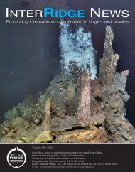
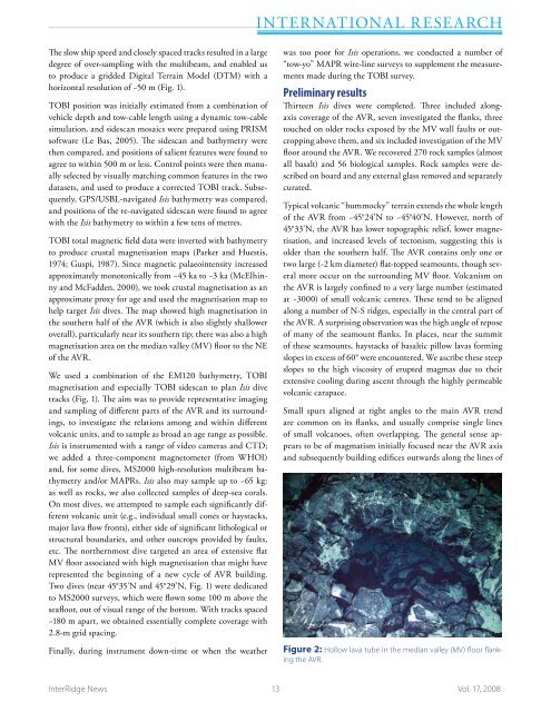
Figure 2: Hollow lava tube in the median valley (MV) floor flanking<br />
the AVR.<br />
<strong>InterRidge</strong> News 13 Vol. 17, 2008