Full version, lower resolution, 3.25MB - InterRidge
Full version, lower resolution, 3.25MB - InterRidge
Full version, lower resolution, 3.25MB - InterRidge

You also want an ePaper? Increase the reach of your titles
YUMPU automatically turns print PDFs into web optimized ePapers that Google loves.
National News<br />
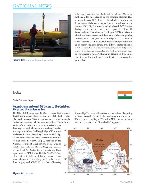
Figure 1: New AUV for German ridge studies.<br />
Other major activities include the delivery of the 6000-m capable<br />
AUV for ridge studies by the company Hydroid LLC<br />
of Massachusetts, USA (Fig. 1). The vehicle is presently undergoing<br />
seatrials before being put into action at Logatchev in<br />
January 2009. Fig. 1 shows the vehicle aboard R/V Poseidon<br />
during these trials. The vehicle can be operated in three different<br />
configurations, either with a Reson 7125D multibeam,<br />
a black and white camera and flash, or a sub-bottom profiler.<br />
Common to all configurations is an Edgetech 2200 side-scan<br />
sonar, a Seabird CTD, an Ecotech backscattering detector, and<br />
an Eh sensor, the latter kindly provided by Koichi Nakamura<br />
of AIST, Japan. On the research front, the German Ridge community<br />
is initiating a proposal to G-cubed for a thematic issue<br />
on slow-spreading ridges. Colin Devey, Nadine Le Bris, Nicole<br />
Dubilier, Jian Lin and Doug Connelly will be put forward as<br />
guest editors.<br />
India<br />
K.A. Kamesh Raju<br />
Recent cruise onboard R/V Sonne to the Carlsberg<br />
Ridge and the Andaman Sea<br />
The NIO-RVS2 cruise from 17 Oct. - 1 Dec. 2007 was conducted<br />
as the second phase field program of the CSIR (India)<br />
- Network Program, “Tectonic and oceanic processes along the<br />
Indian ridge system and the back arc basins.” The main objective<br />
of the cruise was to acquire multiparameter<br />
data together with deep-tow and seafloor imaging<br />
over segments of the Carlsberg Ridge (CR) and the<br />
Andaman Backarc Spreading Center (ABSC; Fig.<br />
1). The cruise was conducted onboard the German<br />
research vessel R/V Sonne (Fig. 2) chartered by the<br />
National Institute of Oceanography (NIO). We also<br />
collaborated with the Hawaii Mapping Research<br />
Group (HMRG), University of Hawaii, and hired<br />
equipment (MAPRs) from PMEL, NOAA (USA).<br />
Observations included multibeam mapping, magnetics,<br />
deep-tow surveys along the rift valley, ocean<br />
floor imaging with OFOS (Ocean Floor Observing<br />
System, Fig. 3) at selected locations, and seabed sampling using<br />
a TV-guided-grab (Fig. 4), dredge, spade core and gravity core.<br />
Water column sampling, CTD and MAPR observations were<br />
also carried out over the CR and ABSC segments.<br />
Figure 1: Cruise track.<br />
<strong>InterRidge</strong> News 34 Vol. 17, 2008