Full version, lower resolution, 3.25MB - InterRidge
Full version, lower resolution, 3.25MB - InterRidge
Full version, lower resolution, 3.25MB - InterRidge

You also want an ePaper? Increase the reach of your titles
YUMPU automatically turns print PDFs into web optimized ePapers that Google loves.
International Research<br />
19 N<br />
(a)<br />
West Mariana Ridge<br />
Mariana Trough<br />
Mariana Arc<br />
(b)<br />
17 10'N<br />
Segment End<br />
18 N<br />
17 N Segment<br />
Segment Center<br />
17 N<br />
17 00'N<br />
Spreading Axis<br />
16 N<br />
142 E 143 E 144 E 145 E 146 E 147 E<br />
-7000 -6000 -5000 -4000 -3000 -2000 -1000 0 Depth (m)<br />
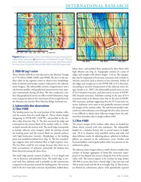
Figure 1: (a) Bathymetry of the central Mariana Trough showing the location<br />
of the study area. (b) Bathymetry of the Mariana Trough 17°N segment.<br />
Black box indicates sidescan sonar survey area. Red, blue, and yellow<br />
lines show Shinkai 6500 dives #1088, #1089, and #1090, respectively.<br />
Median Valley<br />
16 50'N<br />
Spreading Axis<br />
144 40'E 144 50'E 145 00'E<br />
2. YK08-08 Leg-1 cruise<br />
Three Shinkai 6500 dives were devoted to the Mariana Trough<br />
at 17°N (Dives #1088, #1089, and #1090). We dove to the median<br />
valley in the segment center to observe lava morphology<br />
both of smooth and bumpy surfaces indicated in the sidescan<br />
sonar imagery. The submersible carried a magnetometer and a<br />
sub-bottom profiler, and geophysical measurements were operated<br />
continuously during all dives. We also conducted a surface-ship<br />
geophysical survey to collect swath bathymetry, magnetic<br />
and gravity data in the central part of the trough between<br />
the Mariana Arc and the West Mariana Ridge (remnant-arc).<br />
3. Submersible dive observations<br />
3.1 Dive #1088<br />
The landing point was the axial portion of the median valley<br />
and the eastern foot of a small ridge of ~150-m relative height<br />
elongating in NNW-SSE (~N20°W), sub-parallel to the median<br />
valley direction (Fig. 2). The dive traversed the ridge and<br />
continued on the western flank of the median valley at ~3420-<br />
m depth towards the western wall. The small ridge corresponds<br />
to bumpy sidescan sonar imagery, while the portion around<br />
the landing point and the western flank are smooth surfaces<br />
with high backscatter intensity. Morphology at the landing<br />
point was jumbled-wrinkled lavas (Fig. 3). The lava morphology<br />
suggests sheet and turbulent flow at high eruption rates.<br />
The lava flows could be very young, because they show no or<br />
little accumulation of sediment, potentially the freshest lava<br />
flows observed among the three dives.<br />
The small ridge mainly consists of pillow, ~2 m in length and<br />
~1m in diameter, and pahoehoe lavas. The small ridge is covered<br />
with thin sediment and is probably an old construction<br />
compared to the portion around the landing point. The western<br />
half of the dive route had a mixture of pahoehoe, folded sheet,<br />
lobate sheet, and jumbled flows produced by sheet flows with<br />
high effusion rate (Fig. 3). Topography consists of a series of<br />
ridges and troughs with relative height ~5-10 m. The topography<br />
may be originated to be tectonic structures such as faults or<br />
volcanic structures such as fissures or lava channels. Strikes of<br />
the ridges and troughs are in the NNW-SSE or N-S direction.<br />
According to tectonic interpretation of the sidescan sonar images<br />
(Asada et al., 2007), the submersible passed across an area<br />
of N-S lineated structures, and then across an area of NNW-<br />
SSE lineated structures. Sediment coating in the area of N-S<br />
structures tends to be thinner than that in the area of NNW-<br />
SSE structures, perhaps suggesting that the N-S structures are<br />
newer. Sediment cover more or less gradually increases toward<br />
the margin of the median valley. The sub-bottom profiler indicated<br />
very thin sediment cover through the dive route, however<br />
it was difficult to obtain clear reflection images from the sediment/lava<br />
boundary due to rough seafloor relief.<br />
3.2 Dive #1089<br />
The eastern margin of the median valley where we landed has<br />
lobate sheets covered with thin sediments. The submersible<br />
landed on a tumulus feature that is several meters in height<br />
and ~10 m in diameter with wrinkled surface and wide and<br />
deep inflation cracks. In adjoining places, spherical to bulbous<br />
pillows are exposed on the sedimentary cover. Swollen and<br />
fractured pillows and irregular pillow lobes were present on the<br />
sedimentary plain.<br />
The sidescan sonar imagery shows a small volcano complex that<br />
consists of bumpy aggregates of dome-like structures superposed<br />
on fan-shaped lava terraces along the foot of the eastern<br />
valley wall. The terraces appear to be overlain by large domes<br />
100-300 m across that form a broad ridge 1 km east-west and<br />
700 m north-south and 30-40 m in height (Fig. 2). The terraces<br />
are floored by sedimentary plains, with sporadically exposed<br />
<strong>InterRidge</strong> News 25 Vol. 17, 2008