Full version, lower resolution, 3.25MB - InterRidge
Full version, lower resolution, 3.25MB - InterRidge
Full version, lower resolution, 3.25MB - InterRidge

You also want an ePaper? Increase the reach of your titles
YUMPU automatically turns print PDFs into web optimized ePapers that Google loves.
International Research<br />
Axial volcanic ridges (AVRs) appear to be nearly ubiquitous<br />
but non-steady state features of slow-spreading ridge segments.<br />
They are tens of kilometres long, a few kilometres wide and a<br />
few hundred metres high. They consist of thousands of small,<br />
circular volcanoes that presumably overlie fissures and feeder<br />
dykes (Smith and Cann, 1993; Head et al., 1996; Lawson et<br />
al., 1996) and therefore should reflect the composition and development<br />
of the uppermost part of the effusive layer of the<br />
oceanic crust and its mantle sources. Individual volcanoes<br />
range from single small cones ~100 m in diameter to large,<br />
flat-topped edifices ~2 km in diameter and occur singly, in<br />
rows or piled into larger edifices. Differences in the appearance<br />
of individual AVRs (e.g., freshness of volcanic structures,<br />
degree of tectonism) suggest an evolutionary model (Parson et<br />
al., 1993; Head et al., 1996; Briais et al., 2000), in which early<br />
voluminous sheet flows give way to fissure volcanism that is increasingly<br />
focussed into central volcanoes. This model is as yet<br />
untested. AVRs are thought to contain the youngest seafloor in<br />
any segment (Hussenoeder et al., 1996; Smith et al., 1999; Briais<br />
et al., 2000), though estimates of their duration range from<br />
~25 ka (Ballard and Van Andel, 1977; Barclay et al., 1998) to<br />
~600 ka (Thatcher and Hill, 1995; Searle et al., 1998).<br />
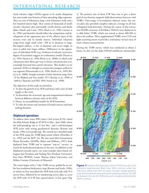
1). The primary aim of these E-W lines was to give a dense<br />
grid of near-bottom magnetic field observations; however, with<br />
TOBI’s 3-km-range, 6-m-<strong>resolution</strong> sidescan sonar, this survey<br />
plan also provided complete sidescan coverage in all four<br />
orthogonal look-directions. During the course of this survey,<br />
two MAPRs (courtesy of Ed Baker, NOAA) were deployed on<br />
a cable below TOBI, which was towed at about 400-500 m<br />
above the seafloor. These supplemented TOBI’s own CTD and<br />
light scattering sensor to provide a continuous vertical array of<br />
water column measurements.<br />
During the TOBI survey, which was conducted at about 2<br />
knots, we also ran the ship’s EM120 multibeam echosounder.<br />
The objectives of this study are therefore:<br />
1. To date the growth of an AVR and hence infer rates of melt<br />
supply to the crust;<br />
2. To determine the structural, age and compositional relations<br />
between different volcanic units of the AVR;<br />
3. Hence, to test published models for AVR formation;<br />
4. To infer the nature and variation of mantle sources and their<br />
melting histories.<br />
Shipboard operations<br />
To address these issues RRS James Cook (cruise JC24) visited<br />
the Mid-Atlantic Ridge at 45°30’N in May - June 2008, where<br />
the half-spreading rate is 11 km Ma -1 , and a well-developed<br />
AVR exists with strong geochemical diversity (Keeton and<br />
Searle, 1996; www.petdb.org). We carried out a detailed study<br />
of the AVR using the TOBI deep-towed vehicle (Flewellen et<br />
al., 1993) and the ROV Isis. We also used Mini-Autonomous<br />
Plume Recorders (MAPRs; Baker and Milburn, 1997), both<br />
deployed from TOBI and in separate “tow-yo” surveys, to<br />
search for hydrothermal plumes in the area. In addition to the<br />
shipboard scientific party, our team includes shore-based colleagues<br />
Jon Davidson and Yaoling Niu (Durham University),<br />
Ken Sims (WHOI), Louise Thomas (Open University), and<br />
Milène Cormier (University of Missouri).<br />
The cruise began with a 7-day TOBI survey, guided by an earlier<br />
low-<strong>resolution</strong> bathymetry map (Keeton and Searle, 1996),<br />
in which we first insonified the AVR from each side with N-S<br />
survey lines, followed by an interleaving survey plan to cover<br />
the AVR with 22 E-W lines spaced about 1.4 km apart (Fig.<br />
Depth (m)<br />
Figure 1: Shaded relief bathymetry of the 45°30’N area with JC24<br />
operations superimposed. Black lines, 500m contours; white line,<br />
TOBI track; yellow lines, ROV Isis tracks; red dots, sample positions<br />
(note that Isis tracks are obscured by the sampling symbols). The AVR<br />
lies between the two N-S TOBI tracks and is roughly outlined by the<br />
3000-m contour.<br />
<strong>InterRidge</strong> News 12 Vol. 17, 2008