Environment Report - Santos
Environment Report - Santos
Environment Report - Santos

You also want an ePaper? Increase the reach of your titles
YUMPU automatically turns print PDFs into web optimized ePapers that Google loves.
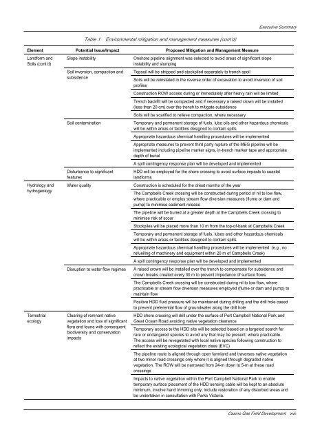
Executive Summary<br />
Table 1<br />
<strong>Environment</strong>al mitigation and management measures (cont’d)<br />
Element Potential Issue/Impact Proposed Mitigation and Management Measure<br />
Landform and<br />
Soils (cont’d)<br />
Hydrology and<br />
hydrogeology<br />
Terrestrial<br />
ecology<br />
Slope instability<br />
Soil inversion, compaction and<br />
subsidence<br />
Soil contamination<br />
Disturbance to significant<br />
features<br />
Water quality<br />
Disruption to water flow regimes<br />
Clearing of remnant native<br />
vegetation and loss of significant<br />
flora and fauna with consequent<br />
biodiversity and conservation<br />
impacts<br />
Onshore pipeline alignment was selected to avoid areas of significant slope<br />
instability and slumping<br />
Topsoil will be stripped and stockpiled separately to trench spoil<br />
Soils will be reinstated in the reverse order of excavation to avoid inversion of soil<br />
profiles<br />
Construction ROW access during or immediately after heavy rain will be limited<br />
Trench backfill will be compacted and if necessary a raised crown will be installed<br />
(less than 20 cm) over the trench to mitigate subsidence<br />
Soils will be scarified to relieve compaction, where necessary<br />
Temporary and permanent storage of fuels, lube oils and other hazardous chemicals<br />
will be within areas or facilities designed to contain spills<br />
Appropriate hazardous chemical handling procedures will be implemented<br />
Appropriate measures to prevent third party rupture of the MEG pipeline will be<br />
implemented including pipeline marker signs, in-trench marker tape and appropriate<br />
depth of burial<br />
A spill contingency response plan will be developed and implemented<br />
HDD will be employed for the shore crossing to avoid surface impacts to coastal<br />
landforms<br />
Construction is scheduled for the driest months of the year<br />
The Campbells Creek crossing will be constructed during period of nil to low flow,<br />
where practicable or employ stream flow diversion measures (flume or dam and<br />
pump) to minimise sediment release<br />
The pipeline will be buried at a greater depth at the Campbells Creek crossing to<br />
minimise risk of scour<br />
Stockpiles will be placed more than 10 m from the top-of-bank at Campbells Creek<br />
Temporary and permanent storage of fuels, lubes and other hazardous chemicals<br />
will be within areas or facilities designed to contain spills<br />
Appropriate hazardous chemical handling procedures will be implemented (e.g., no<br />
refuelling of machinery and equipment within 20 m of Campbells Creek)<br />
A spill contingency response plan will be developed and implemented<br />
A raised crown will be installed over the trench to compensate for subsidence and<br />
crown breaks created every 30 m to prevent impedance of surface flows<br />
The Campbells Creek crossing will be constructed during nil to low flow, where<br />
practicable or stream flow diversion measures employed (flume or dam and pump) to<br />
maintain flow<br />
Positive HDD fluid pressure will be maintained during drilling and the drill hole cased<br />
to prevent preferential flow of groundwater along the drill hole<br />
HDD shore crossing will drill under the surface of Port Campbell National Park and<br />
Great Ocean Road avoiding native vegetation clearance<br />
Temporary access to the HDD site will be selected based on a targeted search for<br />
rare or endangered species to avoid any that may be present, where practicable.<br />
The access will be revegetated with local native species following construction to<br />
reflect the existing ecological vegetation class (EVC)<br />
The pipeline route is aligned through open farmland and traverses native vegetation<br />
at two minor road crossings only where it is aligned through degraded native<br />
vegetation. The ROW will be narrowed from 24-m down to 5-m at these road<br />
crossings<br />
Impacts to native vegetation within the Port Campbell National Park to enable<br />
temporary surface placement of the HDD sensing cable will be kept to an absolute<br />
minimum, involve hand trimming only, include restoration of any disturbed areas and<br />
be undertaken in consultation with Parks Victoria.<br />
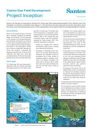
Casino Gas Field Development<br />
xvii