Environment Report - Santos
Environment Report - Santos
Environment Report - Santos

You also want an ePaper? Increase the reach of your titles
YUMPU automatically turns print PDFs into web optimized ePapers that Google loves.
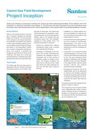
5. Project Description<br />
Table 5.2<br />
Preliminary assessment of shore crossing options<br />
Criteria Option 1<br />
Flaxman’s Hill<br />
Option 2<br />
Lover’s Nook<br />
Option 3<br />
Newfield Bay<br />
Option 4<br />
Two Mile Bay<br />
#1 Horizontal<br />
directional drill<br />
Unknown geotechnical<br />
conditions.<br />
Unknown geotechnical<br />
conditions.<br />
Unknown geotechnical<br />
conditions.<br />
Required drill length (to 15-m<br />
water depth) from outside<br />
Port Campbell National Park<br />
exceeds the current technical<br />
limit for HDD. Therefore, this<br />
option carries significant<br />
technical risk.<br />
Co-located with Minerva and<br />
Otway Gas Project shore<br />
crossings. Known<br />
geotechnical conditions<br />
(Minerva HDD geological<br />
profile has been made<br />
available to <strong>Santos</strong> (<strong>Santos</strong><br />
is a joint venture partner in<br />
the Minerva Project). Key<br />
stakeholders indicated<br />
support for concept of colocation<br />
of shore crossing<br />
site. Required drill length<br />
within technical limits.<br />
#2 Offshore<br />
<strong>Environment</strong><br />
Bathymetry indicates<br />
significant reef outcrops<br />
and rocky seafloor<br />
conditions between gas<br />
field and shore. Confirmed<br />
by commercial fishers<br />
during consultation and<br />
offshore bathymetry<br />
survey.<br />
Bathymetry indicates<br />
significant reef outcrops and<br />
rocky seafloor conditions<br />
between gas field and shore.<br />
Confirmed by commercial<br />
fishers during consultation<br />
and offshore bathymetry<br />
survey.<br />
Bathymetry indicates<br />
significant reef outcrops and<br />
rocky seafloor conditions<br />
between gas field and shore.<br />
Confirmed by commercial<br />
fishers during consultation<br />
and offshore bathymetry<br />
survey.<br />
Bathymetry east of Casino<br />
gas field and near Minerva<br />
indicates significant areas of<br />
sandy seafloor. Confirmed by<br />
commercial fishers during<br />
consultation and offshore<br />
bathymetry survey.<br />
#3<br />
Commercial<br />
Fisheries<br />
Offshore pipeline would<br />
traverse good lobster<br />
fishing grounds.<br />
Creates new pipeline<br />
corridor.<br />
Offshore pipeline would<br />
traverse good lobster fishing<br />
grounds.<br />
Creates new pipeline<br />
corridor.<br />
Offshore pipeline would<br />
traverse good lobster fishing<br />
grounds.<br />
Creates new pipeline<br />
corridor.<br />
Offshore pipeline can avoid<br />
main lobster grounds.<br />
Co-location with Minerva and<br />
Otway Gas Project pipeline<br />
and therefore limits snagging<br />
hazards to one corridor.<br />
Commercial fishers indicated<br />
preference for this option<br />
over others.<br />
#4 Onshore<br />
<strong>Environment</strong><br />
Requires crossing of<br />
Curdies River and<br />
Campbells Creek (both<br />
using existing easements).<br />
Greenfield shore crossing.<br />
Potential for approximately<br />
90% of onshore pipeline<br />
route to follow existing<br />
easements.<br />
Requires crossing of Curdie<br />
River and Campbells Creek<br />
(both using existing<br />
easement). Greenfield shore<br />
crossing. Potential<br />
approximately 90% of<br />
onshore pipeline route to<br />
follow existing easements.<br />
Requires crossing of<br />
Campbells Creek (using<br />
existing easement).<br />
Greenfield shore crossing.<br />
Potential for approximately<br />
80% of onshore pipeline<br />
route to follow existing<br />
easements.<br />
Requires crossing of<br />
Campbells Creek (using<br />
existing easement). Shore<br />
crossing consolidated with<br />
Minerva and Woodside<br />
Otway Gas projects.<br />
Potential to follow existing<br />
easement for 90% of<br />
onshore pipeline route.<br />
or adjacent to existing easements, where<br />
practicable, two options are available<br />
from the HDD site to Smokey Point Road<br />
and three sub-options are then available<br />
from here to the TXU WUGS facility.<br />
Note that the naming protocol for the<br />
various onshore pipeline route options<br />
uses ‘Option 4’ followed by either the<br />
word ‘Minerva’ or ‘Otway’ (depending on<br />
which alignment it follows) and the suboptions<br />
are identified as ‘4A, B or C’.<br />
Between the preferred HDD shore crossing<br />
site at Two Mile Bay (Option 4) and<br />
Smokey Point Road, there are two options<br />
(Figure 5.3):<br />
• Option 4 (Minerva) – follows the existing<br />
Minerva pipeline easement to<br />
the Minerva gas plant and then the<br />
SEAgas pipeline to Smokey Point<br />
Road.<br />
• Option 4 (Otway) – follows the proposed<br />
Woodside Otway Gas Project<br />
alignment to Smokey Point Road.<br />
Between the Smokey Point Road and<br />
the existing TXU WUGS facility, there<br />
are three sub-options (see Figure 5.3):<br />
• 4A – Crosses north over Smokey<br />
Point Road and Cheynes Road South<br />
and follows the existing GasNet Iona<br />
to Portland pipeline into the TXU<br />
WUGS facility.<br />
• 4B – Follows the SEAgas pipeline<br />
from Smokey Point Road into the TXU<br />
WUGS facility.<br />
• 4C – Follows the proposed Woodside<br />
Otway gas pipeline from Smokey<br />
Point Road into the TXU WUGS facility.<br />
Selection of the Preferred Onshore<br />
Pipeline Alignment<br />
The selection and assessment process<br />
for the route alignment was based on:<br />
• <strong>Environment</strong>al impact assessment –<br />
studies of the various alignments<br />
have been conducted by specialist<br />
consultants, based on desktop and<br />
field investigations. The field studies<br />
were undertaken at the end of summer<br />
2004 and included investigations<br />
of:<br />
– Ecology (flora, fauna and stream<br />
ecology).<br />
Casino Gas Field Development 23