VOL 71 No4 - Navy League of Australia
VOL 71 No4 - Navy League of Australia
VOL 71 No4 - Navy League of Australia

Create successful ePaper yourself
Turn your PDF publications into a flip-book with our unique Google optimized e-Paper software.
THE GROUNDING OF HMS NOTTINGHAM (PART 1) . . . continued<br />
BOARD OF INQUIRY INTO THE GROUNDING OF HMS NOTTINGHAM<br />
OFF LORD HOWE ISLAND 7 JULY 2002<br />
INTRODUCTION<br />
1. A Board <strong>of</strong> Inquiry was convened aboard<br />
HMNZS ENDEAVOUR between 13-16 July<br />
2002, to investigate the grounding <strong>of</strong> HMS<br />
NOTTINGHAM <strong>of</strong>f Lord Howe Island. The inquiry<br />
was conducted with the full co-operation <strong>of</strong> the<br />
Commanding Officer and the Ship’s Company<br />
<strong>of</strong> HMS NOTTINGHAM. The aim <strong>of</strong> the Board<br />
<strong>of</strong> Inquiry was to establish the causes and<br />
circumstances surrounding the grounding<br />
<strong>of</strong> HMS NOTTINGHAM on 7 July 2002, and<br />
to report on the matters pertaining to the<br />
subsequent action.<br />
2. Timings in the report refer to ship’s time. A<br />
time zone change was conducted at 0<strong>71</strong>730K<br />
to 0<strong>71</strong>830L July 2002.<br />
3. Not Applicable.<br />
BACKGROUND<br />
4. The Ship’s Programme. The Ship had<br />
emerged from an extensive refit in September<br />
2000 and spent the next six months conducting<br />
sea trials and Safety Readiness Checks, prior<br />
to conducting Basic Operational Sea Training<br />
(BOST) in April-May 2001. Whilst it has not been<br />
confirmed by the Board <strong>of</strong> Inquiry, it is possible<br />
that no external navigation Continuation Training<br />
would have been provided for the ship between<br />
May 01 and Dec 02. It is acknowledged that the<br />
ship had requested support from CMST (Captain<br />
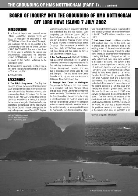
HMS NOTTINGHAM anchored<br />
<strong>of</strong>f Lord Howe Island the day<br />
before her grounding. (RN)<br />
Maritime Sea Training) in September 2002 but,<br />
it is understood, that this was rejected. After<br />
completing Joint Maritime course (JMC) in<br />
June that year, the ship deployed to Oman to<br />
take part in Exercise Argonaut 01/Saif Sarrea<br />
in August, returning to Portsmouth just before<br />
Christmas. After a maintenance period in the<br />
New Year, HMS NOTTINGHAM conducted a<br />
High Seas Firing and then sailed for her Far<br />
East Deployment in March 2002.<br />
5. Far East Deployment. HMS NOTTINGHAM<br />
had sailed from Portsmouth on 18 March to<br />
undertake a nine month deployment to the Far<br />
East including involvement in the Five Powers<br />
Defence Arrangement Exercise, and was<br />
due to undertake high pr<strong>of</strong>ile visits to Tokyo<br />
and Shanghai. The ship sailed from Cairns,<br />
<strong>Australia</strong>, on 4 July and was due to arrive in<br />
Wellington, New Zealand on 9 July.<br />
6. Passage from Cairns to Wellington.<br />
The passage to Wellington had been planned<br />
by a Specialist Fleet Time (Warfare) Officer,<br />
and approved by the Commanding Officer two<br />
weeks previously. The intention was to transit<br />
the Great Barrier Reef, then anchor in the vicinity<br />
<strong>of</strong> Lord Howe Island on 7 July, in order to land<br />
members <strong>of</strong> the Ship’s Company for recreation,<br />
and on an opportunity basis, meet members <strong>of</strong><br />
the local community. At an unspecified time on<br />
the morning <strong>of</strong> 7 July, the Commanding Officer<br />
was informed that there was a requirement to<br />
land a casualty that day for onward move back<br />
to the UK. The ETA at Lord Howe Island was<br />
1600K<br />
7. Lord Howe Island. Lord Howe Island lies<br />
420 nautical miles (nm) to the north east<br />
<strong>of</strong> Sydney and is the southern most <strong>of</strong> the<br />
outlying islands <strong>of</strong>f the east coast <strong>of</strong> <strong>Australia</strong>.<br />
The island is 6nm long and 2nm at the widest<br />
point. There are a number <strong>of</strong> <strong>of</strong>f lying features<br />
including Wolf Rock, a 350 yard by 200 yard<br />
partly submerged rock lying eight cables (1)<br />
to the east <strong>of</strong> the island. The summit <strong>of</strong> this<br />
feature is dome shaped and is reported to be<br />
10 metres in diameter, and has a height <strong>of</strong><br />
1.2m above Mean High Water Springs (MHWS).<br />
MHWS for Lord Howe Island is 1.8 metres.<br />
The chart Aus 610 is a UK Hydrographic Office<br />
copy <strong>of</strong> an <strong>Australia</strong>n chart, and is divided into<br />
four sections. The first section is a 1:150000<br />
scale chart <strong>of</strong> the island and surrounding area,<br />
the second section is a 1:25000 scale chart<br />
showing the island in greater detail, and the<br />
third and fourth sections are 1:12500 scale<br />
showing the lagoon on the western side <strong>of</strong> the<br />
island. The third and fourth sections <strong>of</strong> the<br />
chart do not feature in this inquiry. Although<br />
exact survey details and methods <strong>of</strong> survey are<br />
not known, the chart has a diagram showing<br />
the positional accuracy and depth variation<br />
<strong>of</strong> the survey which gives an indication <strong>of</strong> its<br />
Wolf Rock at high tide. (Chris Sattler)<br />
10 THE NAVY <strong>VOL</strong>. <strong>71</strong> NO. 4<br />
(1) A cable is a tenth <strong>of</strong> a nautical mile or 200 yards.