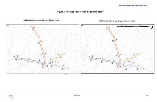
<strong>Annandale</strong> <strong>Transportation</strong> <strong>Study</strong> – Final Report FIGURE 6: Average Peak Period Segment Speeds Figure 6: Average Peak Period Segment Speeds AM Peak Period Average Segment Speeds (mph) PM Peak Period Average Segment Speeds (mph) April 2010 11
<strong>Annandale</strong> <strong>Transportation</strong> <strong>Study</strong> – Final Report TABLE 2: Travel Time Data Collected FIGURE 7: Schematic <strong>of</strong> VISUM/VISSIM Traffic Analysis Methodology Roadway <strong>Annandale</strong> Road McWhorter Pl / John Marr Dr Columbia Pike Backlick Rd Between Distance (miles) Masonville Dr 1.45 0.08 mi East <strong>of</strong> Gallows Rd 0.58 John Marr Dr Ravensworth Rd Columbia Pike 0.74 Little River Turnpike I-495 NB Ramp High Pl (0.15 mi E <strong>of</strong> Evergreen Lane) 1.8 Dir AM Peak Period No. <strong>of</strong> Runs Avg Speed (mi/hr) PM Peak Period No. <strong>of</strong> Avg Speed Runs (mi/hr) NB 2 13.6 2 19.9 SB 3 14.1 3 15.9 EB 3 13.3 3 15.0 WB 3 25.3 3 20.0 NB 3 14.3 2 14.3 SB 3 10.7 2 11.0 EB 4 21.4 4 17.5 WB 4 19.0 4 14.0 Traffic Data O-D Data VISUM Network O-D Trip Table Estimator VISSIM Land Use Scenarios AM/PM O-D Trip tables 2.8. VISUM / VISSIM Modeling To evaluate existing and future transportation alternative networks operations and service <strong>of</strong> land uses in the study area, PTV’s VISUM and VISSIM s<strong>of</strong>tware were utilized. The VISUM s<strong>of</strong>tware allows input <strong>of</strong> traffic volumes, origindestination information, transit systems and operations, and pedestrian and bicycle networks to be modeled at the mesoscopic (local roadway system) level, while the VISSIM model allows detailed operations testing and evaluation <strong>of</strong> networks and alternatives at the microscopic (roadway intersection) level. The VISSIM model allows for creation and input <strong>of</strong> origin-destination (O-D) matrices and performing dynamic trip assignment to adequately evaluate alternative networks where vehicle paths may be altered according to the changes to the transportation network. Further, VISSIM provides system-wide operational performance measures that better capture system-level measured delay and intersection capacities, and provides 3-D visualizations <strong>of</strong> corridor operations that can be used to better identify operational bottlenecks or deficiencies and make appropriate improvement recommendations. Network Improvement Concepts Traffic Micro- Simulation Model MOE’s Animation 2.8.1. Model Development The transportation network inside the <strong>Annandale</strong> CBC study area was coded in detail using VISUM and then exported to VISSIM for detailed operations evaluation. VISUM is a macroscopic traffic network input editor that allows input <strong>of</strong> the transportation network including streets, intersections, signals or other intersection priority, transit routes, and other network details. The VISUM model was also used to estimate origin-destination (O-D) trip tables based on the existing intersection turning movement and roadway link volumes. Coding a detailed network in VISUM makes the VISSIM network development more efficient and enables VISUM to incorporate traffic conditions when estimating the O-D trip table. Once the street network was completed in VISUM and exported to VISSIM, the VISSIM model was constructed and given greater detail, including traffic signal operations, vehicle characteristics, driving behavior, and pedestrian and transit operations. Existing roadway and intersection geometry data such as number <strong>of</strong> lanes by turn movement, length <strong>of</strong> turn bay, lane alignments, stop bar placement, taper lengths, length <strong>of</strong> acceleration/deceleration lanes, and the location and type <strong>of</strong> traffic control devices were obtained through reviewing aerial photos (provided using Google Maps and Micros<strong>of</strong>t Virtual Earth) and verified by field reconnaissance. The VISSIM network also contains the setup for performing dynamic traffic assignment. The VISSIM network was developed to include “nodes” that represented each <strong>of</strong> the traffic analysis zones (TAZ) consistent with <strong>County</strong> subzones. The boundaries <strong>of</strong> the <strong>County</strong> subzones were refined to the VISSIM parking lots. The flowchart in Figure 7 presents a general overview <strong>of</strong> how the proposed VISUM and VISSIM modeling and analysis process was implemented. VISSIM’s capability to provide detailed 3D simulation models - depicting actual operating conditions, providing any audience with the ability to “see” the impacts and operations <strong>of</strong> various transportation systems - is an important tool in evaluating traffic operations. The simulation model will be run for two time periods (AM and PM peak) to determine peak-period operations including intersection delays, queues, signal failures, spillbacks and corridor travel times as well as overall network delays, travel times and vehicles served. The latter will be particularly helpful to determine the overall network efficiency in comparison to several other alternative networks. 2.8.2. Development <strong>of</strong> Existing Origin-Destination Trip Patterns The use <strong>of</strong> dynamic traffic assignment in VISSIM requires input <strong>of</strong> the traffic demand in a trip table. An O-D trip table was estimated using the “TFlow Fuzzy” process in VISUM. Through this process, an O-D trip table is estimated using traffic count data and existing O-D information. <strong>Fairfax</strong> <strong>County</strong> provided O-D information derived from the <strong>Fairfax</strong> <strong>County</strong> <strong>Transportation</strong> Model, and land use information at the subzone level. The TAZs from the <strong>County</strong> model were refined into subzones based upon GIS employment and population data. A by-product <strong>of</strong> this O-D trip table estimator process is the ability to address any potential trip diversion that may take place outside the VISSIM network due to congestion and/or improvements inside the VISSIM network. This capability is important when evaluating multiple networks that alter the trip path by network roadway and/or intersection changes. Once the VISSIM trip assignments were made, a check was done to determine the accuracy <strong>of</strong> the OD derived link volume forecasts with the existing volume data. Appendix B includes a summary <strong>of</strong> the Base Year link and turn movement volume calibration data, showing on the x-axis the link model volume per hour and the y-axis the link volumes as determined by the field data. Overall the R-squared value for the linear regression analysis is 0.99 for both linear regression analyses, which indicates a very good fit to the existing data. April 2010 12