Annandale Transportation Study - Fairfax County Office of ...
Annandale Transportation Study - Fairfax County Office of ...
Annandale Transportation Study - Fairfax County Office of ...

You also want an ePaper? Increase the reach of your titles
YUMPU automatically turns print PDFs into web optimized ePapers that Google loves.
<strong>Annandale</strong> <strong>Transportation</strong> <strong>Study</strong> – Final Report<br />
Poplar Street<br />
Poplar Street is a two-lane undivided collector road. The Poplar Street is a parallel road to Maple Place and serves as<br />
alternative route to residential subdivisions.<br />
Markham Street<br />
Markham Street is a two-lane undivided collector road with a center lane to make turns to local businesses. It provides<br />
alternative access to Little River Turnpike from <strong>Annandale</strong> Road.<br />
McWhorter Place<br />
McWhorter Place is a two-lane undivided local street and serves as a collector road to residential subdivisions. East<br />
and West parts <strong>of</strong> McWhorter Place are not connected.<br />
Tom Davis Drive<br />
Tom Davis Drive (formerly <strong>Annandale</strong> Center Drive) is a short 2-lane local collector between Columbia Pike and John<br />
Marr Drive and serves several municipal buildings in the <strong>Annandale</strong> CBC area.<br />
Medford Drive<br />
Medford Drive north <strong>of</strong> Little River Turnpike is a four-lane collector that serves as a northern by-pass <strong>of</strong> the CBC area<br />
over to <strong>Annandale</strong> Road. South <strong>of</strong> Little River Turnpike, Medford is a two lane local collector that service local<br />
residential homes.<br />
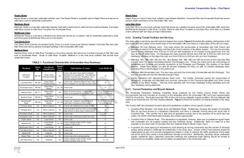
Roadway<br />
Little River<br />
Turnpike<br />
TABLE 1: Functional Characteristic <strong>of</strong> <strong>Annandale</strong> Area Roadways<br />
Route<br />
No.<br />
SR 236<br />
Columbia Pike SR 244<br />
<strong>Annandale</strong> Road SR 650<br />
Gallows Road SR 711<br />
Backlick Road SR 650<br />
Ravensworth<br />
Road<br />
SR 649<br />
Functional<br />
Classification<br />
Urban Other<br />
Principal Arterial<br />
Urban Other<br />
Principal Arterial<br />
Urban Minor<br />
Arterial<br />
Urban Minor<br />
Arterial<br />
Urban Minor<br />
Arterial<br />
Urban Minor<br />
Arterial<br />
Speed<br />
Limit<br />
(mph)<br />
35<br />
25<br />
Total Number <strong>of</strong> Lanes<br />
4-lane road with 5-lane section between<br />
Markham & <strong>Annandale</strong> Rd; Third EB lane<br />
between Hummer and Woodland; Third<br />
WB lane between Medford & Hummer<br />
4-lane road. Between Maple Pl and Little<br />
River Turnpike is a one-way two-lane road<br />
Lane Width (ft)<br />
25 / 35 4-lane road 11’<br />
35<br />
North <strong>of</strong> Hummer Rd is a 4-lane road.<br />
South <strong>of</strong> <strong>Annandale</strong> Rd is a 2-lane road<br />
12’<br />
12’<br />
14-22’ S <strong>of</strong> Hummer;<br />
12 ft N <strong>of</strong> Hummer<br />
30 / 40 4-lane road 11’<br />
30 / 35<br />
2-lane road. Between Jayhawk St and<br />
Little River Turnpike is 4-lane road.<br />
12-14’ S <strong>of</strong> Jayhawk;<br />
12’ N <strong>of</strong> Jayhawk<br />
Hummer Road n/a Minor Collector 35 2-lanes with additional turn lanes at LRT 12’<br />
Heritage Drive n/a Minor Collector 35<br />
4-lane divided road from LRT to <strong>Annandale</strong><br />
High School; 2-lanes east to Ravensworth<br />
Woodlawn Road n/a Minor Collector 35 2-lane road 11’<br />
Evergreen Lane n/a Minor Collector 35 3-lane road (continuous center turn lane) 11’<br />
Poplar Street n/a Local Street 35 2-lane road 11’<br />
Markham St<br />
n/a<br />
Local Street /<br />
Collector<br />
30 / 35<br />
2-lane roadway south <strong>of</strong> LRT; 4-lane<br />
roadway north <strong>of</strong> LRT<br />
McWhorter Place n/a Local Street 30 2-lane road 11’<br />
Tom Davis Drive n/a Minor Collector 35 2-lane road 11’<br />
Medford Dr n/a Collector 35 2-lane road 12’<br />
Maple Place n/a Local Street 25 2-lane road with on-street parking 20’<br />
John Marr Drive n/a Collector 35<br />
4-lane roadway south <strong>of</strong> LRT; 4-lane<br />
divided roadway north <strong>of</strong> LRT<br />
12’<br />
12’<br />
11’ / 12’<br />
Maple Place<br />
Maple Place is a short 2-lane local collector road between Backlick / Columbia Pike and <strong>Annandale</strong> Road that serves<br />
several small businesses in the <strong>Annandale</strong> CBC area.<br />
John Marr Drive<br />
John Marr Drive is a four-lane collector road that serves as a western by-pass around the <strong>Annandale</strong> CBC area from<br />
McWhorter/<strong>Annandale</strong> to Little River Turnpike. North <strong>of</strong> Little River Turnpike to Columbia Pike, John Marr is a divided<br />
4-lane collector with turn bays at major intersections.<br />
2.4.2. Existing Transit Facilities and Services<br />
The study area is served by several local and regional bus routes. Figure 2 illustrates the existing configuration <strong>of</strong> the<br />
bus routes and the location <strong>of</strong> the transit stops in the <strong>Annandale</strong> CBC and below is a description <strong>of</strong> the service routes:<br />
<br />
<br />
<br />
<br />
Metrobus 3A (Lee Highway Line): This route serves the communities <strong>of</strong> <strong>Annandale</strong> and Falls Church and<br />
provides connection to the Rosslyn and East Falls Church stations <strong>of</strong> the Metro System. This bus line provides<br />
service during weekdays from 5:30 am to 9:00 pm with headways <strong>of</strong> 30 minutes during peak-hours and one<br />
hour during <strong>of</strong>f-peak hours. On Saturdays the route provides service from 8:00 am to 8:00 pm with one hour<br />
headways, whereas on Sundays the route runs from 9:00 am to 8:00 pm with one hour headways.<br />
Metrobus 16A, 16B, 16D, 16E and 16L: Bus Routes 16A, 16B, 16D and 16E are known as the Columbia Pike<br />
line and route 16L as the <strong>Annandale</strong>-Skyline City-Pentagon Line. These bus routes serve the communities <strong>of</strong><br />
<strong>Annandale</strong> and Culmore and provide connection to the Pentagon and Pentagon City stations <strong>of</strong> the Metro<br />
System. These lines usually run with 30 minutes headways but they run with 10 minutes headways down<br />
Columbia Pike to the Pentagon in the peak hours.<br />
Metrobus 29H (<strong>Annandale</strong> Line): This bus route connects the community <strong>of</strong> <strong>Annandale</strong> with the Pentagon. This<br />
line only provides service from Monday through Friday.<br />
<strong>Fairfax</strong> Connector 401 (Backlick-Gallows Road Line): The <strong>Fairfax</strong> Connector serves the communities <strong>of</strong><br />
Springfield, <strong>Annandale</strong> and Merrifield and provides connection to the Franconia-Springfield and Dunn Loring<br />
stations <strong>of</strong> the Metro System. This bus route operates with 30-minute headways during weekdays and one<br />
hour headways during weekends.<br />
2.4.3. Current Pedestrian and Bicycle Network<br />
The <strong>Annandale</strong> Pedestrian Walkway Feasibility <strong>Study</strong> prepared for the <strong>Fairfax</strong> <strong>County</strong> Public Works and<br />
Environmental Services included an inventory <strong>of</strong> the sidewalks within the <strong>Annandale</strong> CBC and found approximately<br />
35,630 ft <strong>of</strong> curb line. The study found that 76% <strong>of</strong> the curb line has sidewalk in good condition, 9% has sidewalk that<br />
needs to be improved and 15% has missing sidewalk. Figure 3 shows the locations <strong>of</strong> missing sidewalk in the study<br />
area.<br />
The <strong>County</strong> staff has expressed concerns about the pedestrian conditions at two specific locations:<br />
<br />
<br />
<br />
Columbia Pike between Tom Davis Drive and Backlick Road: Pedestrians crossing this section <strong>of</strong> Columbia<br />
Pike do not have access to a signalized intersection and there is sidewalk missing along the south side <strong>of</strong><br />
Columbia Pike. This corridor has a high level <strong>of</strong> pedestrian activity due to the presence <strong>of</strong> an adult day care<br />
center, the ACCA Child Development facility and a Giant supermarket.<br />
Columbia Pike at Gallows Road: This intersection is signalized, however, there are no pedestrian signal heads<br />
and crosswalks are not properly located and lack handicap ramps. Additionally, there is a need for a new<br />
sidewalk on the south side <strong>of</strong> Columbia Pike from Gallows Road to Martin Taylor Court.<br />
In general, the close spacing <strong>of</strong> intersections, each allowing all turning movements and the number <strong>of</strong> driveway<br />
access points present a challenge for pedestrians in the study area. Access control improvements should be<br />
implemented as part <strong>of</strong> an access management initiative in order to improve the traffic operations <strong>of</strong> the roads<br />
and at the same time create a more pedestrian friendly environment. Additionally, handicap ramps, pedestrian<br />
signals, pedestrian signs, pedestrian pavement markings and pedestrian-scale lighting should be revised to<br />
enhance the accessibility, safety and circulation <strong>of</strong> pedestrians in the <strong>Annandale</strong> area.<br />
April 2010<br />
5