Annandale Transportation Study - Fairfax County Office of ...
Annandale Transportation Study - Fairfax County Office of ...
Annandale Transportation Study - Fairfax County Office of ...

Create successful ePaper yourself
Turn your PDF publications into a flip-book with our unique Google optimized e-Paper software.
<strong>Annandale</strong> <strong>Transportation</strong> <strong>Study</strong> – Final Report<br />
1. INTRODUCTION<br />
<strong>Fairfax</strong> <strong>County</strong>’s Comprehensive Plan for the <strong>Annandale</strong> Community Business Center (CBC) within the <strong>Annandale</strong><br />
Planning District outlines several objectives related to future development. These objectives support a vision for the<br />
<strong>Annandale</strong> CBC area that encourages and guides appropriate <strong>Annandale</strong> revitalization and redevelopment. The<br />
Comprehensive Plan recommends several significant transportation improvements, including the potential widening <strong>of</strong><br />
Little River Turnpike from four to six lanes through the CBC (or an alternate one-way pair configuration), and grade<br />
separating Ravensworth / <strong>Annandale</strong> Roads over Little River Turnpike (or alternative at-grade intersection<br />
improvements). These significant transportation improvements will have a positive impact on the revitalization efforts<br />
in the <strong>Annandale</strong> CBC through the creation <strong>of</strong> additional capacity to support future growth and improved traffic<br />
operations in and around the CBC area. Due to the scope and significance <strong>of</strong> these future projects, this <strong>Annandale</strong><br />
<strong>Transportation</strong> <strong>Study</strong> was conducted to provide a detailed study <strong>of</strong> the transportation network, taking into<br />
consideration that future land use alternatives have the potential to impact capacity and traffic operation<br />
improvements.<br />
The objective <strong>of</strong> the <strong>Annandale</strong> <strong>Transportation</strong> <strong>Study</strong> is to analyze transportation system network alternatives and<br />
develop associated recommendations for a definitive transportation system plan. The desired transportation system<br />
plan for the area should meet the transportation needs for both local and through traffic in an efficient manner, while<br />
facilitating community redevelopment and revitalization needs to enhance the quality <strong>of</strong> life for the community and<br />
neighboring residents, and enable businesses to prosper and actively contribute to the economic and social vitality <strong>of</strong><br />
<strong>Annandale</strong>.<br />
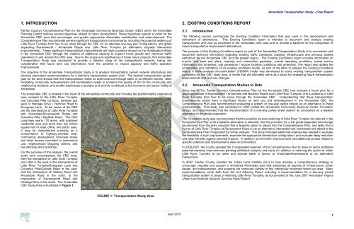
The <strong>Annandale</strong> CBC is located in the heart <strong>of</strong> the <strong>Annandale</strong> community and includes the predominantly commercial<br />
area oriented to the Little River Turnpike<br />
and Columbia Pike corridors, between just<br />
west <strong>of</strong> Heritage Drive / Hummer Road to<br />
Evergreen Lane. At the center <strong>of</strong> the CBC<br />
are the intersections <strong>of</strong> Little River Turnpike<br />
with <strong>Annandale</strong>/Ravensworth Roads and<br />
Columbia Pike / Backlick Road. The CBC<br />
comprises nearly 170 acres, with scattered<br />
residential uses and more than two million<br />
square feet <strong>of</strong> retail, <strong>of</strong>fice, and public uses.<br />
It may be characterized primarily as a<br />
concentration <strong>of</strong> highway-oriented stripcommercial<br />
development, individual stores<br />
and older houses converted to commercial<br />
use, neighborhood shopping centers, and<br />
low-intensity <strong>of</strong>fice buildings.<br />
For the purposes <strong>of</strong> this analysis, the overall<br />
study area encompasses the CBC area,<br />
from the intersection <strong>of</strong> Little River Turnpike<br />
and I-495 in the west, to the intersections <strong>of</strong><br />
Little River Turnpike/Evergreen Lane and<br />
Columbia Pike/Gallows Road in the east;<br />
and the intersection <strong>of</strong> Gallows Road and<br />
<strong>Annandale</strong> Road in the north, to the<br />
intersection <strong>of</strong> Ravensworth Road and<br />
Heritage Drive in the south. The <strong>Annandale</strong><br />
CBC <strong>Study</strong> Area is illustrated in Figure 1.<br />
2. EXISTING CONDITIONS REPORT<br />
2.1. Introduction<br />
The following section summarizes the Existing Condition information that was used in the development and<br />
refinement <strong>of</strong> alternatives. This Existing Conditions report is intended to document and analyze existing<br />
transportation and land us conditions in the <strong>Annandale</strong> CBC area and to provide a baseline for the comparison <strong>of</strong><br />
future transportation improvement alternatives.<br />
The purpose <strong>of</strong> this Existing Conditions report as part <strong>of</strong> the <strong>Annandale</strong> <strong>Transportation</strong> <strong>Study</strong> is to summarize and<br />
document technical information regarding existing traffic conditions, roadway infrastructure and previous studies<br />
performed for the <strong>Annandale</strong> CBC and the greater region. The Existing Conditions report includes information on<br />
current land uses and plans, roadway and intersection geometry, current operating conditions, transit service<br />
information and amenities, and pedestrian / bicycle facilities conditions and amenities. The report also details the<br />
construction and calibration <strong>of</strong> an existing conditions model. As part <strong>of</strong> the effort to prepare the Existing Conditions<br />
report, a traffic-analysis microsimulation (VISSIM) model was developed to study existing transportation system<br />
operations for the CBC study area, a model that will ultimately serve as a basis for evaluating future transportation<br />
improvements and land use changes.<br />
2.2. <strong>Annandale</strong> <strong>Transportation</strong> Studies to Date<br />
Since the 1970’s, <strong>Fairfax</strong> <strong>County</strong>’s Comprehensive Plan for the <strong>Annandale</strong> CBC had included a future plan for a<br />
grade-separation <strong>of</strong> Ravensworth / <strong>Annandale</strong> and Backlick Roads over Little River Turnpike, and a widening <strong>of</strong> Little<br />
River Turnpike from four to six lanes through the <strong>Annandale</strong> CBC. Understanding that these transportation<br />
improvements would have a significant impact on land use and redevelopment in the <strong>Annandale</strong> CBC, the<br />
Comprehensive Plan also recommended evaluating a system <strong>of</strong> one-way paired streets as an alternative to these<br />
improvements. That study was conducted in 2005 (called the <strong>Annandale</strong> Community Business Center Circulation<br />
<strong>Study</strong>), and recommended that the implementation <strong>of</strong> a one-way paired street system be considered as a feasible<br />
alternative to the grade-separation.<br />
The Circulation study also recommended that the possible six-lane widening <strong>of</strong> Little River Turnpike be retained in the<br />
Comprehensive Plan until a feasible alternative is selected, that the provision for a full grade-separated interchange<br />
be removed from the plan; provided that a feasible option is placed into the Comprehensive Plan, and lastly that a<br />
flyover <strong>of</strong> Little River Turnpike at Ravensworth Road (or at an alternative intersection) be considered and added to the<br />
Comprehensive Plan if supported by further analysis. The study indicated additional analysis was needed to evaluate<br />
the feasibility <strong>of</strong> such improvements, examine the appropriate intersection configuration, and evaluate delay reduction<br />
and other benefits against potential impacts. In addition, some interim improvements and additional studies related to<br />
specific potential road improvements were recommended.<br />
In 2006-2007, the <strong>County</strong> updated the <strong>Transportation</strong> element <strong>of</strong> the Comprehensive Plan to allow for some additional<br />
potential roadway improvements pending additional analysis and study (in addition to retaining the option to widen<br />
Little River Turnpike to six lanes and provide either a flyover at <strong>Annandale</strong>/Ravensworth or an alternative<br />
intersection).<br />
In 2007, <strong>Fairfax</strong> <strong>County</strong> solicited the Urban Land Institute (ULI) to help develop a comprehensive strategy to<br />
encourage, regulate and support a revitalized <strong>Annandale</strong> area that addresses all aspects <strong>of</strong> infrastructure, urban<br />
design, and transportation, and supports the continued viability <strong>of</strong> this intrinsically important mixed use area. Many<br />
recommendations came forth from the ULI Advisory Panel, including a recommendation for a two-way paired<br />
transportation system in place <strong>of</strong> widening Little River Turnpike, as documented in the June 2007 <strong>Annandale</strong> Virginia<br />
Urban Land Institute Advisory Services Panel Report.<br />
FIGURE 1: <strong>Transportation</strong> <strong>Study</strong> Area<br />
April 2010<br />
1