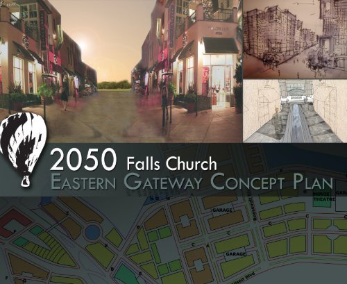
2050 Eastern Gateway Concept Plan - City of Falls Church
2050 Eastern Gateway Concept Plan - City of Falls Church
2050 Eastern Gateway Concept Plan - City of Falls Church

You also want an ePaper? Increase the reach of your titles
YUMPU automatically turns print PDFs into web optimized ePapers that Google loves.
Acknowledgements<br />
<strong>Plan</strong>ning studio work was performed for:<br />
Mr. Rick G<strong>of</strong>f, Economic Development Director,<br />
<strong>City</strong> <strong>of</strong> <strong>Falls</strong> <strong>Church</strong><br />
Suzanne Cotellessa, Development Services Director,<br />
<strong>City</strong> <strong>of</strong> <strong>Falls</strong> <strong>Church</strong><br />
Virginia Tech UAP 5124 <strong>Plan</strong>ning Studio Instructors:<br />
Dr. Shelley Mastran<br />
Mr. Jim Snyder<br />
Virginia Tech UAP 5124 <strong>Plan</strong>ning Studio Students:<br />
Monica Andrews<br />
Inga Beermann<br />
Rudi Byron<br />
Jill Chen<br />
William Cook<br />
Kate Dykgraaf<br />
Ximena Gonzalez Milano<br />
Katrina Kramer<br />
Lara Malak<strong>of</strong>f<br />
Millie O’Neal<br />
Carmelina Perez<br />
Marco Rivero<br />
Julia Rodgers<br />
Mari Russ<br />
Jeremy Sewall<br />
Sian Seys-Evans<br />
Cara Smith<br />
Julie Still<br />
Patt Talvanna<br />
Jessica Turrin<br />
Juan Carlos Vazquez<br />
James Velesz<br />
Maria Villacreces<br />
Raymond Vuong<br />
Chris Winnike<br />
Joshua Yetter<br />
Kate Youngbluth
Table <strong>of</strong> Contents<br />
1. Introduction and Vision<br />
2. Existing Conditions<br />
3. <strong>2050</strong> <strong>Eastern</strong> <strong>Gateway</strong> <strong>Plan</strong><br />
• Roosevelt and Wilson<br />
• Eden Center<br />
• Koons and Syms<br />
4. Transportation Network<br />
5. Office and Retail Analysis<br />
6. Implementation and Impacts
I.<br />
Introduction<br />
and Vision
Introduction and Vision<br />
The Project<br />
A group <strong>of</strong> architecture, landscape architecture, and urban<br />
planning graduate students from Virginia Tech’s Alexandria<br />
Center worked for the <strong>City</strong> <strong>of</strong> <strong>Falls</strong> <strong>Church</strong> Economic<br />
Development Authority to create a vision and plan for the<br />
<strong>Eastern</strong> <strong>Gateway</strong> area in the <strong>City</strong> <strong>of</strong> <strong>Falls</strong> <strong>Church</strong>. UAP 5124, a<br />
planning studio class, <strong>of</strong>fered the students the opportunity to<br />
apply their academic pursuits to a real-world client and<br />
community in transition. The <strong>City</strong> <strong>of</strong> <strong>Falls</strong> <strong>Church</strong> was enthusiastic<br />
to have a fresh set <strong>of</strong> eyes study an aging commercial area<br />
that <strong>of</strong>fers a great opportunity for redevelopment during the<br />
next 40 years.<br />
The UAP 5124 students assumed a build-out date <strong>of</strong> <strong>2050</strong> for<br />
the proposed <strong>Eastern</strong> <strong>Falls</strong> <strong>Church</strong> <strong>Gateway</strong> plan. The class<br />
broke the proposed development plan <strong>of</strong> the approximately<br />
65-acre site into three plan areas to be redeveloped through<br />
the rezoning application process. The studio assumed that<br />
transportation improvements would occur creating a new road<br />
network and enhanced transit, walking, and bicycling facilities.<br />
The students also assumed that a mixed-use zoning district<br />
would be created for the area that permitted increased<br />
densities, building heights and urban design.<br />
The planning studio spent several weeks studying appropriate<br />
urban design densities, speaking with the members <strong>of</strong> the <strong>Falls</strong><br />
<strong>Church</strong> planning and economic development departments and<br />
local developers and regional experts on planning. The studio<br />
conducted a site visit to the <strong>Eastern</strong> <strong>Gateway</strong> site prior to the<br />
development <strong>of</strong> the overall concept plan. Once the limits <strong>of</strong> the<br />
overall concept plan area were defined, three plan areas were<br />
identified for study. The plan areas were defined as the Koons-<br />
Syms area, the Eden Center area, and the Roosevelt-Wilson<br />
area.<br />
The 27 members <strong>of</strong> the studio organized in groups that<br />
developed plans, models, and analysis for the densities, heights<br />
and uses within the three area plans, architecture concepts for<br />
the buildings, streetscape designs, a multimodal transportation<br />
network, and an overall economic development analysis. On<br />
December 10, 2009, the studio class developed a presentation<br />
for the <strong>Falls</strong> <strong>Church</strong> Economic Development Authority to discuss<br />
the concepts and analysis for the <strong>Eastern</strong> <strong>Gateway</strong>. Finally, the<br />
studio drafted text that provided a detailed analysis and a<br />
description for each plan area and included a narrative on the<br />
streetscape design, transportation network and economic<br />
analysis. <strong>Plan</strong>s and architectural drawings were developed for<br />
each <strong>of</strong> the area plans to provide an illustrative example <strong>of</strong> the<br />
proposed development described by the text. The analysis and<br />
plans were compiled into this report and provided to members<br />
<strong>of</strong> the <strong>Falls</strong> <strong>Church</strong> Economic Development Authority.
The Vision<br />
In <strong>2050</strong> the <strong>Falls</strong> <strong>Church</strong> <strong>Eastern</strong> <strong>Gateway</strong> will be<br />
a vibrant, mixed-use, multimodal<br />
economic asset to the city. Its tree-lined<br />
streets will welcome pedestrians and<br />
bicyclists and create a 24-hour-a-day<br />
community.
The <strong>Plan</strong><br />
The proposed plan for the <strong>Falls</strong> <strong>Church</strong> <strong>Eastern</strong> <strong>Gateway</strong><br />
consists <strong>of</strong> a comprehensive set <strong>of</strong> area-specific plan<br />
recommendations that will promote a vibrant mixed-use<br />
community for the area’s future development. The<br />
recommendations are based on a vision for the area that<br />
promotes increased densities, urban design standards and an<br />
enhanced transportation network. The plan will significantly<br />
increase the commercial tax base and improve the economic<br />
viability <strong>of</strong> the area; at the same time, it will preserve the<br />
unique existing historic and cultural features located in the<br />
eastern boundary <strong>of</strong> the <strong>City</strong> <strong>of</strong> <strong>Falls</strong> <strong>Church</strong>.<br />
Route 7 (Leesburg Pike) slices through the <strong>Eastern</strong> <strong>Gateway</strong><br />
and is a major road in the region. Source: Marco Rivero.<br />
The <strong>Eastern</strong> <strong>Gateway</strong><br />
is the front door <strong>of</strong><br />
<strong>Falls</strong> <strong>Church</strong> from<br />
Arlington and Fairfax<br />
Counties. The existing<br />
conditions <strong>of</strong> the area<br />
have no distinct<br />
features that clearly<br />
identify the entrance<br />
into the <strong>City</strong>. Bounded<br />
by major arterials<br />
that serve the region<br />
(Route 7, Route 50,<br />
Wilson Boulevard,<br />
and Roosevelt<br />
Boulevard), the existing developments are a combination <strong>of</strong><br />
aging auto-oriented uses and strip commercial developments.<br />
For purposes <strong>of</strong> the vision, the plan has established three major<br />
areas for redevelopment.<br />
• The Koons-Syms plan area includes the two Koons auto<br />
dealerships, the vacant Syms retail store and two<br />
parcels in Fairfax County: the existing Grand Market<br />
grocery store parcel and adjacent Italian Inn restaurant.<br />
• The Eden Center plan area includes the Edens Center<br />
and vacant Wholesale Liquidators store, the BP Gas<br />
Station and the two parcels in Fairfax County that<br />
contain the veterinary clinic and parking lot.<br />
• The Roosevelt-Wilson Boulevard plan area includes<br />
Oakwood Apartments, Madison Condominium, Roosevelt<br />
Towers Apartments, Koons Body Shop, Public Storage,<br />
the Shell Gas Station, the Wilson Boulevard Strip retail<br />
development and the future BJ’s Wholesale store site.<br />
Because the site is bounded by four-lane major arterials,<br />
including Leesburg Pike (Route 7), Arlington Boulevard (Route<br />
50), Wilson Boulevard, Roosevelt Boulevard and Hillwood<br />
Avenue, the plan calls for an enhanced streetscape design for<br />
the plan areas that addresses the elements needed to calm<br />
automobile traffic and create an active street life. Proposed
streetscape improvements address the need to activate the<br />
street by including wider sidewalks, bicycle lanes, café seating,<br />
and enhanced lighting and landscaping. The improved<br />
streetscape design will provide an attractive location to<br />
facilitate a 24-hour-a-day community.<br />
Open spaces were strategically located<br />
throughout the site to encourage<br />
residents, visitors and employees <strong>of</strong> the<br />
area to gather, recreate outdoors and<br />
provide a central place for public events.<br />
Public and private underground garages<br />
are located throughout the site to<br />
encourage individuals to leave behind<br />
their cars and walk throughout the blocks<br />
created by the enhanced street network<br />
for the area. A transit center has been<br />
added to the center <strong>of</strong> the site to<br />
encourage individuals to visit the site via<br />
alternative modes <strong>of</strong> transportation such<br />
as by bus and eventually by streetcar.<br />
Pedestrian-bicycle paths are located<br />
along the perimeter <strong>of</strong> the site to provide pedestrians and<br />
bicyclists with a protected pathway for circulation.<br />
Thriving businesses at Eden Center. Source: Marco Rivero.<br />
Center is <strong>of</strong> international importance to the region’s<br />
Vietnamese-American citizens, because <strong>of</strong> the agglomeration <strong>of</strong><br />
Vietnamese and other Asian-owned retailers within its limits.<br />
Consideration for the two cultural sites and preservation <strong>of</strong> the<br />
existing Oakwood Cemetery were key factors in the design <strong>of</strong><br />
the plan for the <strong>Eastern</strong> <strong>Gateway</strong>.<br />
The plan envisions that the <strong>Eastern</strong> <strong>Gateway</strong><br />
retain the culturally significant and thriving<br />
businesses in the Eden Center while<br />
increasing the overall commercial tax-base<br />
<strong>of</strong> the <strong>City</strong> <strong>of</strong> <strong>Falls</strong> <strong>Church</strong> through creation<br />
<strong>of</strong> a significant increase in <strong>of</strong>fice density. To<br />
promote the <strong>Eastern</strong> <strong>Gateway</strong> as a 24-houra-day<br />
community, the plan envisions dense<br />
residential developments, public gathering<br />
spaces, and recreational and park areas<br />
throughout the site. New development should<br />
adhere to the established city design<br />
guidelines and ensure multimodal access to<br />
and from the site. Consistent with its<br />
comprehensive plan, the city should dedicate<br />
recreational areas and open spaces to enhance quality <strong>of</strong> life<br />
for future residents and employees in the <strong>Eastern</strong> <strong>Gateway</strong>.<br />
The <strong>Eastern</strong> <strong>Gateway</strong> contains several culturally significant sites,<br />
which the plan intends to preserve and enhance through design.<br />
Fort Taylor Park, as a Civil War Union Army base, is a<br />
historically significant area <strong>of</strong> the region and is located along<br />
the western portion <strong>of</strong> the Koons auto dealership site. The Eden<br />
The plan has carefully considered transitions between the<br />
<strong>Eastern</strong> <strong>Gateway</strong> and the surrounding, stable neighborhoods.<br />
The edges <strong>of</strong> the <strong>Eastern</strong> <strong>Gateway</strong> provide a buffered, heavily<br />
landscaped area for recreational open space to preserve and<br />
emphasize the transition between the dense developments
contemplated along the Roosevelt-Wilson Boulevard and the<br />
Koons-Syms plan areas. A building height restriction and<br />
residential uses are planned for the westernmost portion <strong>of</strong> the<br />
Syms site, which contemplates a significant height reduction from<br />
the eastern portion <strong>of</strong> the site to the neighborhood adjacent to<br />
the westernmost portion <strong>of</strong> the site. The proposed developments<br />
along the border <strong>of</strong> the site should be low density and provide<br />
a village-like feel to the pedestrians. The large existing parcels<br />
within the <strong>Eastern</strong> <strong>Gateway</strong> have been broken up by an<br />
extensive street and pedestrian network; appropriate block<br />
lengths should be incorporated into the design and should<br />
accommodate on-street parking, bicycle lanes and trafficcalming<br />
measures. To mitigate existing visual clutter within the<br />
corridor, all utilities should be undergrounded as part <strong>of</strong><br />
redevelopment projects.<br />
<strong>Plan</strong>ning Objectives<br />
Objective 1: To achieve a cohesive and orderly planned<br />
development, the <strong>City</strong> <strong>of</strong> <strong>Falls</strong> <strong>Church</strong> must coordinate future<br />
land use developments with the clear urban design guidance for<br />
the <strong>Eastern</strong> <strong>Gateway</strong>. Unified signage, streetscape<br />
improvements, building design and orientation, street furniture,<br />
lighting, and landscaping should be <strong>of</strong> an established style<br />
throughout the area.<br />
Objective 2: Retain the culturally significant businesses in the<br />
area to continue to serve the niche international market.<br />
Promote commercial revitalization and investment through<br />
marketing and permit significantly increased <strong>of</strong>fice and<br />
residential mixed-use densities.<br />
Objective 3: Create buffers and height restrictions at the<br />
<strong>Eastern</strong> <strong>Gateway</strong>’s edges to provide a transition between highdensity<br />
mixed-use developments and the existing residential<br />
neighborhoods.<br />
Objective 4: Foster carefully phased development plans by<br />
crafting parcel-specific comprehensive plan language for each<br />
plan area and encourage lot consolidation where necessary.<br />
Adopt a mixed-use zoning district that encourages a denser<br />
urban form to be developed through carefully timed phased<br />
development plans.<br />
Objective 5: Ensure that transportation improvements are<br />
pr<strong>of</strong>fered through redevelopment and revitalization activities.
2.<br />
Existing<br />
Conditions
Existing Conditions<br />
Geography, History, and Development<br />
The <strong>Falls</strong> <strong>Church</strong> <strong>Eastern</strong> <strong>Gateway</strong> site lies at the convergence<br />
<strong>of</strong> Route 50, Route 7, and Wilson Boulevard on the eastern<br />
edge <strong>of</strong> the <strong>City</strong> <strong>of</strong> <strong>Falls</strong> <strong>Church</strong> and just seven miles outside <strong>of</strong><br />
Washington, D.C. The site is at the nexus <strong>of</strong> <strong>Falls</strong> <strong>Church</strong> and<br />
Arlington and Fairfax Counties, and serves as a gateway for<br />
nearly one million commuters daily. The Seven Corners area<br />
gets its name from the identifiable intersection <strong>of</strong> many <strong>of</strong> the<br />
area’s major arteries.<br />
The three major roads in and around the <strong>Falls</strong> <strong>Church</strong> <strong>Eastern</strong><br />
<strong>Gateway</strong> Corners <strong>Gateway</strong> site are Wilson Boulevard, Broad<br />
Street/Route 7, and Roosevelt Boulevard, but the site is also<br />
bordered to the south by Route 50/Arlington Boulevard, a<br />
major east-west artery between Washington, D.C. and points<br />
west. Wilson Boulevard begins east <strong>of</strong> the Seven Corners<br />
<strong>Gateway</strong> site in Arlington County. It runs the length <strong>of</strong><br />
Arlington’s Rosslyn-Ballston transit corridor, enters the<br />
boundaries <strong>of</strong> <strong>Falls</strong> <strong>Church</strong>, and ends when it hits Broad<br />
Street/Route 7 inside the <strong>Falls</strong> <strong>Church</strong> <strong>Eastern</strong> <strong>Gateway</strong> site.<br />
Roosevelt Boulevard connects the <strong>Falls</strong> <strong>Church</strong> segment <strong>of</strong><br />
Wilson Boulevard and Route I-66 and the East <strong>Falls</strong> <strong>Church</strong><br />
Metro station, approximately one mile to the north. Broad<br />
Street/Route 7 runs north from Alexandria and Annandale,<br />
through <strong>Falls</strong> <strong>Church</strong> <strong>City</strong> and the gateway site, and is the<br />
primary street serving downtown <strong>Falls</strong> <strong>Church</strong>, which is located<br />
about 1.5 miles to the northwest <strong>of</strong> the <strong>Falls</strong> <strong>Church</strong> <strong>Eastern</strong><br />
<strong>Gateway</strong>.<br />
Figure 2.1 shows links to and from the <strong>Falls</strong> <strong>Church</strong> <strong>Eastern</strong><br />
<strong>Gateway</strong> to major Northern Virginia and Metropolitan<br />
Washington, D.C. areas. In part because <strong>of</strong> its proximity to<br />
several Northern Virginia transportation arteries, the <strong>Falls</strong><br />
Figure 2.1: Greater Geographical Context for <strong>Falls</strong><br />
<strong>Church</strong> <strong>Eastern</strong> <strong>Gateway</strong><br />
To Downtown <strong>Falls</strong><br />
<strong>Church</strong><br />
To I-495 Capital<br />
Beltway, Fairfax<br />
To East <strong>Falls</strong><br />
<strong>Church</strong> Metro,<br />
Route I-66<br />
To Alexandria<br />
Annandale<br />
To Arlington,<br />
Rosslyn-Ballston<br />
Corridor<br />
To Washington, DC
<strong>Church</strong> <strong>Eastern</strong> <strong>Gateway</strong> suffers from severe traffic congestion.<br />
However this proximity to these major arteries, along with<br />
proximity to alternative forms <strong>of</strong> transportation such as Metro,<br />
bus, and bicycle routes, makes the site a likely candidate for<br />
urban-style redevelopment.<br />
Site Features<br />
The area <strong>of</strong> study encompasses several identifiable <strong>Falls</strong> <strong>Church</strong><br />
locations, including:<br />
A. The Eden Center (6763 Wilson Boulevard), a<br />
Vietnamese-American shopping center located near the<br />
center <strong>of</strong> the site, bordered by Roosevelt Boulevard to<br />
the east, Wilson Boulevard to the south, East Broad<br />
Street/Arlington Boulevard to the west, and the<br />
Oakwood Cemetery to the north;<br />
B. The Koons <strong>Falls</strong> <strong>Church</strong> Ford dealership and body shop<br />
(1051 East Broad Street);<br />
C. The former Syms department store site (1000 East<br />
Broad Street), which currently sits empty;<br />
D. The 12-acre Oakwood Cemetery, along the north edge<br />
<strong>of</strong> the site, bordered by Roosevelt Street, divides the<br />
sprawling, auto-oriented commercial development from<br />
nearby single-family residential neighborhoods to the<br />
north and west;<br />
E. The future site <strong>of</strong> an 87,000-square-foot BJ’s Wholesale<br />
Warehouse on the north side <strong>of</strong> Wilson Boulevard and<br />
on the east side <strong>of</strong> Roosevelt Boulevard; and<br />
F. Fort Taylor Park and Civil War historical site.<br />
Adjacent sites include:<br />
G. The landmark 12-story twin BB&T towers located just<br />
over the <strong>Falls</strong> <strong>Church</strong> <strong>City</strong> border on the southwestern<br />
edge <strong>of</strong> the site in Fairfax County; and<br />
H. The Seven Corners Shopping Center, located to the<br />
southwest <strong>of</strong> the site, and bordered by Route 7 and<br />
Route 50/Arlington Boulevard;<br />
Figure 2.2: Features <strong>of</strong> the <strong>Eastern</strong> <strong>Gateway</strong><br />
G<br />
C<br />
F<br />
B<br />
D<br />
A<br />
H<br />
E
Size<br />
The approximately 65-acre <strong>Eastern</strong> <strong>Gateway</strong> site includes the<br />
12 acre Oakwood Cemetery and 58 acres, or 2.5 million<br />
square feet, <strong>of</strong> developable land. Table 3.1 on the following<br />
page provides detailed acreage and square footage<br />
information for each parcel within the three areas <strong>of</strong> interest<br />
within the Seven Corners <strong>Gateway</strong> Site and for Oakwood<br />
Cemetery.<br />
History <strong>of</strong> Development<br />
A Sprawling Commercial Center<br />
Though the <strong>City</strong> <strong>of</strong> <strong>Falls</strong> <strong>Church</strong> was established in 1875, it was<br />
around 1948, when <strong>Falls</strong> <strong>Church</strong> became an independent city,<br />
that the <strong>Eastern</strong><br />
<strong>Gateway</strong> began to<br />
develop into what it<br />
is today. As the<br />
Washington, D.C.<br />
metropolitan area<br />
began to expand in<br />
the mid 20th<br />
century, the <strong>City</strong> <strong>of</strong><br />
<strong>Falls</strong> <strong>Church</strong> was<br />
well-positioned to<br />
accommodate the<br />
impending suburban development. Due to its location at the<br />
intersection <strong>of</strong> several major arteries connecting it to<br />
Washington, D.C. to the east and expanding Northern Virginia<br />
development to the west, <strong>Falls</strong> <strong>Church</strong> welcomed its first<br />
suburban-style shopping center in 1953. While the 1953 Seven<br />
Corners Shopping Center is not located within <strong>Falls</strong> <strong>Church</strong>, its<br />
early success encouraged similar suburban development, with<br />
single-use buildings, vast surface parking areas, and limited<br />
access to public transportation, to spring up and spread.<br />
The site and the surrounding areas in Arlington and Fairfax<br />
Counties grew to become the typically auto-oriented mid-20th<br />
century suburban commercial development, where patrons could<br />
conveniently drive their cars directly to strip shopping centers,<br />
car dealerships, and large grocery stores. But in the last<br />
decade, there has been a shift away from suburban autooriented<br />
commercial development in favor <strong>of</strong> more traditional<br />
main street-type development. This has led to the demise <strong>of</strong> the<br />
development typical <strong>of</strong> the <strong>Falls</strong> <strong>Church</strong> <strong>Eastern</strong> <strong>Gateway</strong> site.<br />
For example, shortly after the Seven Corners Shopping Center<br />
was built, a Jelleff’s Department Store at 1000 E. Broad Street<br />
was built in 1956. Typical <strong>of</strong> suburban retail development, the<br />
store was surrounded by a sea <strong>of</strong> surface parking. Eventually,<br />
Jelleff’s closed its <strong>Falls</strong> <strong>Church</strong> store in favor <strong>of</strong> more popular<br />
locations such as the developing Tysons Corner. In 1978, the<br />
store building was taken over by the Syms Corporation, which<br />
was successful until it too closed the 1000 East Broad Street
Table 3.1: Seven Corners/<strong>Falls</strong> <strong>Church</strong> <strong>Gateway</strong> Parcel Acreage and Square Footage<br />
Site 1: Koons/Syms<br />
Site Name Parcel Number Site Address Acreage Square Footage<br />
Koons Main Site 53-218-145 1101 E. Broad Street 6.70 292,043<br />
Water Tower 53-218-016 <strong>Falls</strong> <strong>Church</strong>, VA 22205 0.21 9,000<br />
Vet Shelter 53-218-008 6801 Wilson Boulevard 0.34 14,670<br />
North Edge <strong>of</strong> Koons Site 53-218-042 1051 E. Broad Street 0.22 9,502<br />
Fort Taylor Park 53-218-041 N. Roosevelt Street 0.43 18,686<br />
Hillwood Avenue Parcel 53-217-001 Hillwood Ave/Roosevelt Blvd 0.35 15,333<br />
Hillwood East 53-217-002 Hillwood Avenue 0.36 15,600<br />
Koons/Syms Site Total 8.61 374,834<br />
Site 2: Eden Center<br />
Site Name Parcel Number Site Address Acreage Square Footage<br />
Eden Center 53-218-006 6795 Wilson Boulevard 15.32 667,383<br />
Eden Center Gas Station 53-218-005 6701 Wilson Boulevard 0.40 17,320<br />
Wilson Blvd Retail Parcel 53-218-007 6799 Wilson Boulevard 0.43 18,921<br />
Eden Center Total 16.15 703,624<br />
Site 3: Roosevelt Boulevard/Wilson Boulevard<br />
Site Name Parcel Number Site Address Acreage Square Footage<br />
Oakwood Apartments 53-218-014 501 Roosevelt Boulevard 12.14 528,821<br />
Madison Condo 53-218-144 600 Roosevelt Boulevard 2.26 98,407<br />
Roosevelt Towers Apts. 53-218-019 500 Roosevelt Boulevard 5.15 224,334<br />
Public Storage 53-218-021 400 Roosevelt Boulevard 1.48 64,603<br />
Koons Body Shop 53-218-020 410 Roosevelt Boulevard 2.71 118,042<br />
Shell Gas Station 53-218-004 6623 Wilson Boulevard 0.49 21,425<br />
Wilson Blvd Commercial 53-218-003 6609 Wilson Boulevard 0.65 28,385<br />
BJ's Wholesale Warehouse 53-218-002 6607 Wilson Boulevard 8.30 361,575<br />
Roosevelt/Wilson Total 33.19 1,445,592<br />
Other<br />
Site Name Parcel Number Site Address Acreage Square Footage<br />
Oakwood Cemetery 53-218-013 N. Roosevelt Street 11.48 500,000<br />
Oakwood Cemetery Total 11.48 500,000<br />
Acreage Square Footage<br />
<strong>Falls</strong> <strong>Church</strong>/Seven Corners <strong>Gateway</strong> Site Total 69.42 3,024,050
location and moved into a potentially more lucrative location in<br />
2009. Since Syms vacated the site, the building remains empty<br />
until it is made available for redevelopment.<br />
The Eden Center<br />
Unlike most <strong>of</strong> the rest <strong>of</strong> the <strong>Eastern</strong> <strong>Gateway</strong> site, the Eden<br />
Center, which makes up almost a quarter <strong>of</strong> the <strong>Falls</strong> <strong>Church</strong><br />
Seven Corners <strong>Gateway</strong> site, successfully transformed itself<br />
from another suburban strip mall to one <strong>of</strong> <strong>Falls</strong> <strong>Church</strong>’s largest<br />
and most successful commercial developments. In addition to<br />
bringing successful commerce to <strong>Falls</strong> <strong>Church</strong>, the development<br />
had a dual role as an east coast tourist attraction. Vietnamese-<br />
Americans travel from around Northern Virginia, the D.C.<br />
metropolitan area, and beyond to visit the almost 150<br />
Vietnamese-owned food, retail, and service establishments. 1<br />
Entering the United States en masse in the mid- to late-1970’s<br />
and early-1980’s after the fall <strong>of</strong> Saigon, Vietnamese<br />
immigrants <strong>of</strong> all pr<strong>of</strong>essions, levels <strong>of</strong> education, and economic<br />
status settled in Northern Virginia. Today, Vietnamese<br />
immigrants number 50,000 in the Washington, D.C.<br />
metropolitan area, with the majority living in the Northern<br />
Virginia suburbs. Many, in search <strong>of</strong> storefront space at cheap<br />
rents, established restaurants and retail stores in declining areas<br />
like Clarendon in Arlington. Their presence helped Clarendon<br />
develop into a bustling downtown area with a strong<br />
Vietnamese-American community presence.<br />
In search <strong>of</strong> more affordable space to relocate their businesses,<br />
many Vietnamese shop owners moved to a strip shopping<br />
center just outside <strong>of</strong> Arlington in <strong>Falls</strong> <strong>Church</strong>. Now <strong>of</strong>ficially<br />
named the Eden Center, but <strong>of</strong>ten referred to as “Little Saigon,”<br />
the shopping center houses almost 150 Vietnamese-owned<br />
establishments. The suburban shopping center has evolved into<br />
a hub <strong>of</strong> activity and commerce for both <strong>Falls</strong> <strong>Church</strong> and the<br />
Vietnamese community. By 1984, nearly 60 percent <strong>of</strong> the<br />
area’s Vietnamese immigrants had settled within three miles <strong>of</strong><br />
the <strong>Eastern</strong> <strong>Gateway</strong> site, and they were utilizing the Eden<br />
Center for shopping and services, as well as social and cultural<br />
center. 2 But, with its popularity, Eden Center developed the<br />
problems typical <strong>of</strong> suburban shopping centers across the<br />
country, including congestion, high rents, and limited parking.
These are issues that the <strong>City</strong> <strong>of</strong> <strong>Falls</strong> <strong>Church</strong> hopes to deal with<br />
in future redevelopment <strong>of</strong> Eden Center, while retaining as<br />
many <strong>of</strong> the Vietnamese-American tenants as possible in the<br />
process.<br />
Constraints and Opportunities<br />
The <strong>Eastern</strong> <strong>Gateway</strong> site presents several constraints and<br />
opportunities for redevelopment.<br />
Constraints:<br />
• Oakwood Cemetery. The cemetery is a constraint in<br />
that it takes up a large, centrally located portion <strong>of</strong> the<br />
site. This limits the ability to create internal pathways to<br />
facilitate movement and creates some odd-shaped<br />
parcels. In addition, it limits the ability to make<br />
connections between the site and the neighborhoods <strong>of</strong><br />
<strong>Falls</strong> <strong>Church</strong> immediately to the west.<br />
• Proximity to Fairfax County Line. The ability to create<br />
a node <strong>of</strong> activity is limited to what <strong>Falls</strong> <strong>Church</strong> has<br />
direct influence on, but which is directly affected by<br />
development immediately adjacent in the Fairfax<br />
County portion <strong>of</strong> Seven Corners. This includes the odd<br />
parcel <strong>of</strong> the animal hospital that appears to be in <strong>Falls</strong><br />
<strong>Church</strong> but is actually located in Fairfax County.<br />
• Unfriendly Pedestrian Environment. Vehicles driving<br />
through Seven Corners are not alerted to the presence<br />
<strong>of</strong> pedestrians, sidewalks are minimal where they exist<br />
at all, and pedestrian crossings are hazardous.<br />
Attracting street life will be difficult as long as Seven<br />
Corners is primarily seen as a vehicular intersection.<br />
• No Major Transit Stop on Site. Attracting pedestrians<br />
and thus a more lively street life will be challenging<br />
because Seven Corners does not have a major transit<br />
station to bring people who will walk. There is an extralarge<br />
bus stop at the Seven Corners shopping mall in<br />
Fairfax County, but the <strong>Falls</strong> <strong>Church</strong> portion <strong>of</strong> Seven<br />
Corners does not include even a bus shelter; pedestrian<br />
connections between this Seven Corners bus stop and the<br />
<strong>Eastern</strong> <strong>Gateway</strong> are hazardous and unfriendly.<br />
• Negative Perception <strong>of</strong> Seven Corners. In general,<br />
Seven Corners is not regarded as a pleasant place to<br />
be by local residents, who instead view it as a<br />
frustrating, confusing, and congested intersection.<br />
• Successful But Congested Eden Center. Eden Center is<br />
a thriving retail shopping center that could benefit from<br />
redevelopment and density intensification. A challenge<br />
for redevelopment will be keeping the smaller,<br />
Vietnamese-American tenants operational and successful<br />
during the construction <strong>of</strong> a redeveloped Eden Center.<br />
Opportunities:<br />
• Elevation. The <strong>Falls</strong> <strong>Church</strong> portion <strong>of</strong> Seven Corners<br />
includes some <strong>of</strong> the highest terrain in the area.
Enhancing these views by building tall structures would<br />
increase desirability for <strong>of</strong>fices and residents to locate<br />
here.<br />
• Eden Center. The Eden Center is one <strong>of</strong> the most<br />
successful commercial areas in the <strong>City</strong> <strong>of</strong> <strong>Falls</strong> <strong>Church</strong>,<br />
and has an established reputation, especially among the<br />
Vietnamese community, that draws visitors from around<br />
the world.<br />
• Oakwood Cemetery. While this cemetery presents a<br />
constraint in terms <strong>of</strong> connectivity between the <strong>Falls</strong><br />
<strong>Church</strong> neighborhood immediately to its west and the<br />
Seven Corners site, the cemetery also provides an<br />
existing green space that could serve the function <strong>of</strong> a<br />
park and create desirable views for neighboring <strong>of</strong>fices<br />
and residents.<br />
market interest <strong>of</strong> the majority <strong>of</strong> this traffic.<br />
• Existing Tall Buildings. The BB&T towers and the<br />
residential units along Roosevelt Avenue provide an<br />
existing precedent for high-density development in this<br />
area, such that creating a larger cluster <strong>of</strong> increased<br />
density would be more palatable to residents and<br />
business owners in this area.<br />
• Historic Site. <strong>Falls</strong> <strong>Church</strong> should capitalize on this<br />
location for its historical significance <strong>of</strong> being the first<br />
place that a military balloon was launched to perform<br />
aerial reconnaissance at Fort Taylor Park. This historic<br />
event could fuel a thematic development <strong>of</strong> the site that<br />
could attract those with interests in military history,<br />
balloons, the Civil War, and others.<br />
• Proximity to East <strong>Falls</strong> <strong>Church</strong> Metro Station. This site<br />
is very close to an existing heavy rail transit stop, such<br />
that it could be easily connected to it via shuttle buses or<br />
more frequent bus service, at a minimum, thus drawing<br />
pedestrian traffic to the site.<br />
• Location at a Major Intersection. The fact that Route 7<br />
and Route 50, two <strong>of</strong> Northern Virginia’s main<br />
thoroughfares, intersect at Seven Corners provides an<br />
excellent market space due to the high volume <strong>of</strong> traffic<br />
passing through. By redeveloping its portion <strong>of</strong> Seven<br />
Corners, <strong>Falls</strong> <strong>Church</strong> would be poised to capture the
Demographics<br />
All demographic information was gathered from the U.S. Census<br />
available at www.census.gov. Overall demographic information<br />
from 2008 is listed below for the three jurisdictions.<br />
<strong>Falls</strong> <strong>Church</strong>, VA<br />
• 10,600 residents in 2005; anticipated 2010 population<br />
(MCOG) is 12,300<br />
• 85% white; 8.4% Hispanic; 6.5% Asian; 3.3% African<br />
American<br />
• Median age <strong>of</strong> 39.7 (highest in region)<br />
• Median household income is $74,924<br />
• 39.4% housing is renter occupied<br />
Fairfax County, VA<br />
• 1,015,302 residents in 2008<br />
• 67% white; 13.5% Hispanic; 15.8% Asian; 9.4 African<br />
American<br />
• Median age is 39.1<br />
• Median household income is $106,785<br />
• 26% <strong>of</strong> housing is renter occupied<br />
Arlington County, VA<br />
• 209,969 was the population in 2008<br />
• 70.5% white; 15.9% Hispanic; 8.9% Asian; 8.1%<br />
African American<br />
• Median age is 37.6<br />
• Median household income is $96,390<br />
• 48% housing is renter occupied<br />
This information provides a very broad look at the surrounding<br />
areas. Census data from the block group level was gathered to<br />
provide a closer look at the areas within a half-mile from the<br />
gateway site. The drawback <strong>of</strong> this data is that it is from the<br />
2000 census and not current. On the following pages are maps,<br />
graphs, and charts that show the population density and<br />
average household income <strong>of</strong> each block group, the age<br />
distribution, travel time to work information, housing stock<br />
information, and racial break down for the entire site.
Figure 2.3: Population Density in <strong>Eastern</strong> <strong>Gateway</strong><br />
Figure 2.4: Average Income in <strong>Eastern</strong> <strong>Gateway</strong>
Figure 2.5: Residents by Race near <strong>Eastern</strong> <strong>Gateway</strong><br />
Figure 2.6: Residents by Age near <strong>Eastern</strong> <strong>Gateway</strong><br />
Racial Break Down Within 1/2 Mile <strong>of</strong> Site<br />
Age Distribution Around Site<br />
1800<br />
White<br />
African American<br />
American Indian<br />
Asian<br />
Other Race Alone<br />
Tw o or More Races<br />
11.59%<br />
0.47%<br />
4.18%<br />
9.72%<br />
3.93%<br />
70.11%<br />
These data indicate that the population <strong>of</strong> the <strong>Eastern</strong> <strong>Gateway</strong><br />
and adjacent areas is affluent, with average income levels well<br />
over $62,000 per capita, and with many homes at more than<br />
$100,000. The population is 70 percent white, with about 10<br />
percent African American and 10 percent Asian. The age<br />
distribution chart indicates that the population is mostly made<br />
up <strong>of</strong> people aged 30-60, older than average for the United<br />
States as a whole. This population is presently organized in lowto<br />
medium-density settlements.<br />
Number <strong>of</strong> People<br />
1600<br />
1400<br />
1200<br />
1000<br />
800<br />
600<br />
400<br />
200<br />
0<br />
0-5<br />
6-12<br />
13-17<br />
18-21<br />
22-24<br />
25-29<br />
30-34<br />
35-39<br />
40-44<br />
45-49<br />
Age Range<br />
50-54<br />
55-59<br />
60-64<br />
65-69<br />
70-74<br />
75-79<br />
80-84<br />
85+
Existing Land Use, Future Land Use, Zoning, and<br />
<strong>Plan</strong>s for Redevelopment<br />
Our three study subareas, Roosevelt Blvd/Wilson Blvd, The<br />
Eden Center and Koons/Syms sites, currently consist <strong>of</strong> similar<br />
land uses, densities, and general characteristics. While the site is<br />
located in the <strong>City</strong> <strong>of</strong> <strong>Falls</strong> <strong>Church</strong>, Arlington and Fairfax<br />
Counties are immediately adjacent, which provides both great<br />
challenges and opportunities for redevelopment. Increased<br />
coordination and joint planning efforts need to be augmented<br />
for current and future development.<br />
Existing Land Use Classifications<br />
Roosevelt Boulevard/Wilson Boulevard<br />
A mix <strong>of</strong> uses occupies independent sites along Roosevelt and<br />
Wilson Boulevards. The <strong>Falls</strong> <strong>Church</strong><br />
Existing Land Use Map shows Light<br />
Industrial/Auto and Shopping<br />
Center uses at the intersection <strong>of</strong><br />
Wilson and Roosevelt. North on<br />
Roosevelt Blvd, the multifamily<br />
apartment designation is in use. 3<br />
The Eden Center<br />
The Eden Center is its own<br />
independent shopping center area<br />
which is located directly in front <strong>of</strong><br />
multi-family apartment dwellings<br />
and a cemetery. This site is strictly<br />
commercial; there is no mixed-use activity.<br />
Koons/Syms<br />
The Koons/Syms site is split between <strong>City</strong> <strong>of</strong> <strong>Falls</strong> <strong>Church</strong> and<br />
Fairfax County jurisdictions. On the <strong>Falls</strong> <strong>Church</strong> side, there are<br />
two distinct uses, Light Industry/Auto (Koons Ford Dealership)<br />
and also Individual Retail/Service (the former Syms building).<br />
The Fairfax County portion <strong>of</strong> the site across the street from<br />
Hillwood Ave contains a now vacant Grand Mart (former Giant<br />
Food Grocery Store), which used to be a commercial/retail<br />
use. 4<br />
<strong>Falls</strong> <strong>Church</strong> and Fairfax County's Comprehensive <strong>Plan</strong>s<br />
<strong>Falls</strong> <strong>Church</strong> and Fairfax County’s respective comprehensive<br />
plans address future land use considerations. Exploring these<br />
intended land uses and how they relate to the study sites is<br />
important when creating an overall development plan.<br />
Roosevelt Boulevard/Wilson Boulevard<br />
According to <strong>Falls</strong> <strong>Church</strong>'s 2005 Comprehensive <strong>Plan</strong>, the<br />
Roosevelt Boulevard/Wilson Boulevard area is intended to be<br />
a major business and mixed-use development area. Higher<br />
densities are expected for this site, and the existing multi-family<br />
residential use is preserved within the plan. The comprehensive<br />
plan provides greater opportunities for integrated development<br />
and greater business/<strong>of</strong>fice/residential development potential.
The Eden Center<br />
The Eden Center will remain a business/commercial center, as is<br />
explicitly identified within the comprehensive plan. The site’s<br />
retail commercial uses will remain. There would be potential for<br />
greater redevelopment and density if mixed-use development<br />
were also allowed on that site.<br />
Koons/Syms<br />
This site, which was primarily a single use commercial and light<br />
industry/auto use area, would generate larger densities and<br />
diverse, commercial uses. The 2005 Comprehensive <strong>Plan</strong><br />
identifies these areas to be specifically business sites with a<br />
transitional area included near the western part <strong>of</strong> Syms for<br />
possibly residential and commercial redevelopment. 5<br />
Fairfax County also expresses interest on this particular site<br />
through their 2007 Comprehensive <strong>Plan</strong>. The 2007 Fairfax<br />
County Comprehensive plan states:<br />
"As an option, Parcels 51-3((1))2 and 3, located directly at<br />
the intersection <strong>of</strong> Arlington Boulevard and Hillwood Avenue<br />
may be considered for retail and/or <strong>of</strong>fice use up to .50 FAR<br />
if the two parcels are consolidated and access coordinated<br />
with Virginia Plaza or provided as far west <strong>of</strong> the intersection<br />
as possible.<br />
As a further option, the entire sub-unit may be considered for<br />
retail/<strong>of</strong>fice mixed use up to .70 FAR provided that full<br />
consolidation is achieved and higher structures are located to<br />
the east, away from adjacent residential areas. At this higher<br />
intensity, a traffic study at the time <strong>of</strong> redevelopment should<br />
be performed." 6<br />
Regarding the intersection at Arlington Boulevard and Hillwood<br />
Avenue, the current densities and projected land use densities<br />
for that site are not high. Achieving a mixed-use retail/<strong>of</strong>fice<br />
build-out for this area would require greater densities and<br />
greater connectivity with the Syms site. This can be achieved<br />
through enhanced pedestrian connectivity and enhanced<br />
congestion management strategies.<br />
Existing Zoning Requirements: <strong>Falls</strong> <strong>Church</strong> and Fairfax<br />
Zoning classifications and details usually concur with the existing<br />
land use and may also correlate with future land use strategies.<br />
Both <strong>Falls</strong> <strong>Church</strong> <strong>City</strong> and Fairfax County clearly identify the<br />
zoning classifications for these three sites and the permitted uses<br />
within them.<br />
Roosevelt Boulevard/Wilson Boulevard<br />
Currently, this section <strong>of</strong> our study area has three predominant<br />
zoning classifications. The first is the M-1 zoning district, Light<br />
Industry. M-1 allows for all commercial uses described in the B-<br />
1 Limited Business, B-2 Central Business, and B-3 General<br />
Business districts. Within the B-3 General Business district, there<br />
is a 75-feet building height maximum or seven stories (building<br />
height maximum for B-1 is 55 feet). Nurseries, greenhouses,<br />
carpentry, building supplies, and automotive sales are allowed<br />
but at a maximum height <strong>of</strong> 55 feet. 7 Within applicable<br />
commercial and industrial sites, a special exception provision
and mixed-use redevelopment zoning overlay allow<br />
developers/businesses to obtain height and density bonuses.<br />
M-1 specifically allows for all commercial uses in B-1, B-2, and<br />
B-3 commercial districts with the exception <strong>of</strong> dwellings, schools,<br />
and hospitals. 8 M-1 also allows for industrial research and<br />
development facilities, manufacturing businesses, automotive<br />
body repair facilities, kennels, animal hospitals, building<br />
material storage yards, and other listed uses. 9 The land use<br />
range within this zoning district allows for much flexibility, and<br />
also creates greater opportunities for more expansive and<br />
vertical development through a mixed-use overlay zone.<br />
This site also contains the R-M or Multi-Family Residential<br />
district. This district allows for high-density residential<br />
multifamily, attached dwellings which can be apartments or<br />
condominiums. The density is 16 to 31 dwelling units per acre.<br />
The sizes and densities for these sites may differ significantly<br />
but must not exceed this standard. 10 This district was created<br />
primarily to instill development that would be near major<br />
transportation nodes, stores, <strong>of</strong>fices, and community facilities.<br />
This district also allows the uses specified in the B-1, Limited<br />
Business zoning district. 11<br />
Finally, this area also contains the C-D or Creative Development<br />
district. This district was intended to be a special development<br />
district area that would accommodate various use types and<br />
configurations. This district idea was used to develop projects<br />
such as Whittier Park, a 62-townhouse and hotel development<br />
project located at the 300 and 400 blocks <strong>of</strong> Hillwood<br />
Avenue. 12 It also was used to build the Oakwood Apartments<br />
development, located at 501 Roosevelt Blvd which includes 576<br />
units (roughly 47 units per acre). 13 The C-D district was<br />
repealed in 2003 and now the option for mixed-use<br />
redevelopment sites (MURs) is allowed as a by-right zoning<br />
tool.<br />
The Eden Center<br />
The Eden Center area contains only one zoning district, the M-1<br />
zoning district, Light Industry. All uses and classifications for M-1<br />
(mentioned in the previous subsection) apply to this site.<br />
Koons/Syms<br />
Koons/Syms has the B-3, General Business district (discussed in<br />
more detail above) specifically encompassing the Koons car<br />
dealership and the Syms department store site. Located<br />
northwest <strong>of</strong> the same parcel, there is a transitional zoning<br />
district, T-1 or Transitional 1. This zoning classification allows for<br />
pr<strong>of</strong>essional <strong>of</strong>fices and parking facilities. T-1 also allows for<br />
residential uses, such as detached single family dwellings,<br />
duplexes, and townhouses on properties larger than three<br />
acres. 14<br />
The southern parcel <strong>of</strong> the site within Fairfax County is zoned C-<br />
7, a Regional Retail Commercial District. This zone district allows<br />
for commercial uses such as community clubs, restaurants,<br />
bowling alleys, colleges/universities, churches, hotels, and<br />
<strong>of</strong>fices subject to all conditions within the Fairfax County Zoning<br />
Ordinance (FCZO). 15 The minimum lot area is 40,000 square<br />
feet with a minimum width <strong>of</strong> 200 feet; these measurements
may be waived by the Fairfax County Board <strong>of</strong> Supervisors<br />
subject to conditions listed in Section 9-610 <strong>of</strong> the FCZO.<br />
Maximum building height is 90 feet and may be increased<br />
under approval by the Board <strong>of</strong> Supervisors under Section 9-<br />
607. Minimum floor area ratio (FAR) is 0.80, but an increase <strong>of</strong><br />
1.0 may be permitted by the Board <strong>of</strong> Supervisors under<br />
Section 9-618. 16 All regulations listed pertain to existing land<br />
use classifications and zoning requirements, which will be subject<br />
to change in this study.<br />
Transportation and Parking<br />
Average Daily Traffic<br />
The <strong>Eastern</strong> <strong>Gateway</strong> and adjacent communities in <strong>Falls</strong> <strong>Church</strong><br />
and Arlington experience relatively high traffic volumes from<br />
commuters and residents working, shopping, and doing business<br />
in the area. Table 3.2 highlights the principal and minor<br />
arterials serving the <strong>Eastern</strong> <strong>Gateway</strong>, and the related traffic<br />
counts obtained from the Virginia Department <strong>of</strong><br />
Transportation. 17<br />
Existing Transit Services<br />
The <strong>Falls</strong> <strong>Church</strong> <strong>Eastern</strong> <strong>Gateway</strong> and East <strong>Falls</strong> <strong>Church</strong> Metro<br />
Station are generally well served by a range <strong>of</strong> local and<br />
regional public transportation services, including GEORGE, the<br />
Washington Metropolitan Area Transportation Authority<br />
(WMATA) and Arlington Transit (ART). A brief description <strong>of</strong> the<br />
providers’ services to <strong>Falls</strong> <strong>Church</strong> and the study area are<br />
described below, with Table 3.3 including further details such as<br />
fares and service hours for the routes that serve <strong>Falls</strong> <strong>Church</strong><br />
from each system. Note that bus services to the East and West<br />
<strong>Falls</strong> <strong>Church</strong> Metro Stations are highlighted because these two<br />
stations represent the major transit hubs that provide access to<br />
<strong>Falls</strong> <strong>Church</strong>, though the stations physically lie just outside the<br />
city boundaries. See Appendix A for route maps and schedules,<br />
where available.<br />
Table 3.2: VDOT Traffic Counts at Major Road Segments in the <strong>Falls</strong><br />
<strong>Church</strong>’s <strong>Eastern</strong> <strong>Gateway</strong> (2008)<br />
Virginia<br />
State<br />
Route 7<br />
U.S.<br />
Route<br />
338<br />
Roosevelt<br />
Street<br />
Roosevelt<br />
Boulevard<br />
Street Name Type Traffic Counts AADT/AA<br />
WDT<br />
Leesburg Pike, Principal From Cherry 22,000/2<br />
Broad Street Arterial St to East 4,000<br />
Corporate<br />
Hillwood<br />
Avenue<br />
N/A<br />
N/A<br />
Minor Arterial<br />
Urban<br />
Collector<br />
Urban Minor<br />
Arterial<br />
Limit<br />
From Cherry<br />
St to South St<br />
From Route 7<br />
to Tuckahoe St<br />
From the<br />
South<br />
Corporate<br />
Limit <strong>Falls</strong><br />
<strong>Church</strong> to<br />
Roosevelt St<br />
8,500/9,<br />
300<br />
2,400/2,<br />
600<br />
18,000/2<br />
0,000
GEORGE Bus 18<br />
The <strong>City</strong> <strong>of</strong> <strong>Falls</strong> <strong>Church</strong> has its own local bus service, called<br />
GEORGE, which consists <strong>of</strong> two loops that connect to the East<br />
and West <strong>Falls</strong> <strong>Church</strong> Metro stations. The 26E route consists <strong>of</strong><br />
a loop on the eastern side <strong>of</strong> the city, which serves the East <strong>Falls</strong><br />
<strong>Church</strong> Metro station and provides a connection to the northern<br />
portion <strong>of</strong> the study area, along Roosevelt Street. The 26W<br />
route serves the western side <strong>of</strong> the city with a connection to the<br />
West <strong>Falls</strong> <strong>Church</strong> Metro station. Both routes meet at Broad<br />
Street and Virginia Avenue, where passengers can transfer<br />
between the services. GEORGE operates on weekdays during<br />
the peak periods, mainly serving commuters who need to reach<br />
the Metro stations.<br />
GEORGE service uses 24-passenger, 30-feet-long, low-floor<br />
transit buses that are wheelchair accessible and contain Clever<br />
Devices, which announce and display stops along the routes.<br />
These buses are clean diesel buses with Exhaust Gas<br />
Recirculation systems, which filter particulate matter and lower<br />
noise levels. The <strong>City</strong> <strong>of</strong> <strong>Falls</strong> <strong>Church</strong> has fully funded GEORGE<br />
service since December 2004, and the buses are maintained<br />
and operated by Arlington County.<br />
The <strong>City</strong> <strong>of</strong> <strong>Falls</strong> <strong>Church</strong> is considering eliminating the GEORGE<br />
bus service due to its current budgetary shortfall. 19 Eliminating<br />
the GEORGE bus would severely inhibit efforts to make the<br />
<strong>Falls</strong> <strong>Church</strong> <strong>Eastern</strong> <strong>Gateway</strong> a pedestrian-oriented<br />
development, because the 26E route is the only public transit<br />
link between the East <strong>Falls</strong> <strong>Church</strong> Metro station and the study<br />
area. This will negatively impact transit-dependent populations,<br />
including those without cars and those unable to drive, in<br />
particular. It will also hurt efforts to encourage choice or<br />
discretionary riders to get out <strong>of</strong> their cars and use transit. In<br />
order to support a thriving commercial development in the <strong>Falls</strong><br />
<strong>Church</strong> <strong>Eastern</strong> <strong>Gateway</strong>, a direct and frequent link to the East<br />
<strong>Falls</strong> <strong>Church</strong> Metro station will be indispensable unless and until<br />
an alternate public transit option became available, such as a<br />
bus depot or light rail station.<br />
WMATA Metrorail and Metrobus<br />
Two stations provide access to <strong>Falls</strong> <strong>Church</strong> via the Orange Line<br />
<strong>of</strong> the Metrorail system, though neither is physically located<br />
within <strong>City</strong> boundaries. The East <strong>Falls</strong> <strong>Church</strong> station, the major<br />
Metro station in proximity to the study area, is located at 2001<br />
North Sycamore Street. This station includes 33 short-term<br />
metered parking spots, 422 all day parking spaces, 86 bike<br />
racks, and 36 bike lockers. 20 The West <strong>Falls</strong> <strong>Church</strong> station is<br />
located at 7040 Haycock Road, and includes 45 short-term<br />
metered parking spots, 2,009 all day parking spaces, 40 bike<br />
racks, and 22 bike lockers. 21 Both stations have reserved<br />
parking among the all day spaces, where customers pay $55<br />
for a reserved monthly parking permit, in addition to the daily<br />
parking fee <strong>of</strong> $4.50. Reserved spaces are available until 10<br />
a.m., after which any unused spaces are open to all customers. 22<br />
All the reserved spaces at the East <strong>Falls</strong> <strong>Church</strong> Station are<br />
currently filled, while some are still available at the West <strong>Falls</strong><br />
<strong>Church</strong> station. 23 Carsharing is also available at both stations<br />
and is described in further detail below.
Several Metrobus routes serve the East <strong>Falls</strong> <strong>Church</strong> station: 2A,<br />
2B, 2C, 2G, 3A, 3B, 3E, and 24T. The Route 2 series operates<br />
along Washington Boulevard to Vienna and Oakton. The<br />
number 3 routes A, B, and E comprise the Lee Highway Line,<br />
which provide connections between the Rosslyn, East <strong>Falls</strong><br />
<strong>Church</strong>, and West <strong>Falls</strong> <strong>Church</strong> Metro Stations, as well as<br />
Annandale. Route 24T connects McLean to East <strong>Falls</strong> <strong>Church</strong>.<br />
Routes 28 A and B run between Alexandria and Tyson’s Corner,<br />
serving Bailey’s Crossroads, Seven Corners, and <strong>Falls</strong> <strong>Church</strong> via<br />
Route 7. In addition, Metrobus routes 1A, 1B, 1Z, and 1E serve<br />
Figure 2.7: Study Area Circled in Red. Source: WMATA<br />
the study area, with the first three serving the Eden Center and<br />
Route 1E stopping at Wilson Boulevard and McKinley Road.<br />
These routes provide connections to Vienna, INOVA Fairfax<br />
Hospital, Dunn-Loring, Merrifield, Fairview Park, Dominion Hills,<br />
and Ballston.<br />
ART 24<br />
ART Routes 52 and 53 serve the East <strong>Falls</strong> <strong>Church</strong> station and<br />
provide <strong>Falls</strong> <strong>Church</strong> residents with access to destinations in<br />
Arlington. ART 52 provides service from the East <strong>Falls</strong> <strong>Church</strong><br />
station through North Arlington to Virginia Hospital Center and<br />
the Ballston-MU Metro Station. ART 53 also connects the East<br />
<strong>Falls</strong> <strong>Church</strong> and Ballston-MU Stations, but travels through<br />
several neighborhoods in North Arlington.
Table 3.2: Summary <strong>of</strong> Transit Services in Vicinity <strong>of</strong> <strong>Falls</strong> <strong>Church</strong> <strong>Eastern</strong> <strong>Gateway</strong><br />
Transit Routes that Service Days and Hours Service Frequency Fares<br />
System Serve <strong>Eastern</strong><br />
<strong>Gateway</strong> or<br />
<strong>Falls</strong> <strong>Church</strong><br />
GEORGE 26E, 26W Mon-Fri, 6:00-9:40 a.m. and 25-30 minutes Regular and senior fares: $1.00<br />
WMATA<br />
Metrorail<br />
WMATA<br />
Metrobus<br />
Orange Line<br />
(East <strong>Falls</strong> <strong>Church</strong><br />
and West <strong>Falls</strong><br />
<strong>Church</strong> Stations)<br />
1A, 1B, 1E, 1Z,<br />
2A, 2B, 2C, 2G,<br />
3A, 3B, 3E, 24T,<br />
4:00-7:40 p.m.<br />
Mon-Thurs, 5:00 a.m.-12:00 a.m.;<br />
Fri, 5:00 a.m.-3:00 a.m.; Sat,<br />
7:00 a.m.-3:00 a.m.; Sun, 7:00<br />
a.m.-12:00 a.m.<br />
Mon-Fri, 4:50 a.m.-12:50 a.m.;<br />
Sat/Sun, 5:40 a.m.-12:40 a.m.<br />
2-6 minutes during peak<br />
periods, 7-20 minutes during<br />
non-peak periods<br />
About 30 minutes during peak<br />
periods, hourly otherwise<br />
28A, 28B<br />
ART 52, 53 Mon-Fri, 6:00 a.m.-9:25 p.m. 30 minutes during peak<br />
periods, hourly otherwise<br />
Regular fare: $1.65-$4.50,<br />
Reduced fare: $1.35-$2.35<br />
(fares vary by distance), S/D<br />
fare: half the regular fare<br />
Regular fare: $1.35, S/D fare:<br />
$0.60<br />
Regular cash fare: $1.35,<br />
Regular fare with SmarTrip card:<br />
$1.25, S/D fare: $0.60<br />
Notes: S/D represents senior/disabled fare. For WMATA and Fairfax Connector services, up to two children, ages 4 and younger, may ride for free with each<br />
paying customer. For ART services, children under age five ride for free.
Bicycle Network<br />
The well-travelled Washington and Old Dominion (W&OD)<br />
bike trail runs from Purcellville to Alexandria and traverses <strong>Falls</strong><br />
<strong>Church</strong>, entering the city near the West <strong>Falls</strong> <strong>Church</strong> station,<br />
approximately two miles from the redevelopment area. The<br />
W&OD trail crosses over Route 7, which provides bicycle<br />
commuters coming from the west with an easy 2-mile trip from<br />
the trail to the site. Bicycle commuters coming from the east can<br />
exit the trail at North Sycamore Street less than one mile from<br />
the site. Shown in Figure 2.8, <strong>Falls</strong> <strong>Church</strong> also has a local<br />
bicycle route, which connects to regional trails, though the<br />
existing route does not travel to the study area.<br />
Several transit providers encourage connections between<br />
bicycling and riding transit by providing bicycle storage and<br />
transporting bicycles. Both Metrorail and Metrobus<br />
accommodate bicycles. Bikes may be taken onto Metrorail cars<br />
except for weekdays during peak hours and during special<br />
events or holidays with large crowds. All Metrobuses are<br />
equipped with two bike racks each, and bikes are permitted on<br />
buses during peak periods as well. The East <strong>Falls</strong> <strong>Church</strong> Metro<br />
station has bike racks, which are free and available on a firstcome,<br />
first-served basis, and lockers that may be rented for<br />
$70 annually. ART buses are also equipped with bike racks,<br />
which are free <strong>of</strong> charge for transit riders to use when bringing<br />
bikes on the buses. 25
Fig 2.8: Bicycle Facilities in <strong>City</strong> <strong>of</strong> <strong>Falls</strong> <strong>Church</strong> Source: <strong>City</strong> <strong>of</strong> <strong>Falls</strong> <strong>Church</strong> Transportation Website,
Parking Facilities<br />
Drivers have only one parking option in the <strong>City</strong> <strong>of</strong> <strong>Falls</strong><br />
<strong>Church</strong>’s <strong>Eastern</strong> <strong>Gateway</strong>: private parking lots. city-owned<br />
parking lots are located in downtown <strong>Falls</strong> <strong>Church</strong> (on or<br />
adjacent to West Broad Street). <strong>Plan</strong>s to build additional<br />
parking facilties are slated for the <strong>City</strong> Center redevelopment<br />
area. 26 Transit riders can park at the East <strong>Falls</strong> <strong>Church</strong> Metro<br />
Station, which has 422 all-day spaces and 33 short-term<br />
metered spaces. 27<br />
Some commercial centers, such as the Eden Center, lack<br />
sufficient parking. The Eden Center is <strong>Falls</strong> <strong>Church</strong>’s largest<br />
retail center, as well as the cultural and social center <strong>of</strong> the<br />
Vietnamese-American community. 28 With approximately 1,000<br />
parking spaces, insufficient parking remains a problem due to<br />
high demand maintained during weekends and major holidays<br />
such as the New Moon Festival. Some Eden Center patrons<br />
report on Yelp.com, a popular restaurant review site, that they<br />
feel parking at the Eden Center “takes forever,” is “a<br />
headache” and a “terrible pain.” 29 Other than spot<br />
reconfiguration, there are no immediate solutions available due<br />
to the scarcity <strong>of</strong> surrounding land. 30<br />
(Left) Congested parking at Eden Center during a Christmas holiday. (Right) While parking is in high<br />
demand at Eden Center, this photo shows a significant amount <strong>of</strong> unused surface parking. Source: Capital<br />
<strong>City</strong> Partners’ Presentation to the <strong>City</strong> <strong>of</strong> <strong>Falls</strong> <strong>Church</strong>, www.fallschurchva.gov.<br />
Parking requirements in <strong>Falls</strong> <strong>Church</strong> reflect traditional suburban<br />
sensibilities regarding <strong>of</strong>f-street parking and land use. Table<br />
2.3, on the following page, indicates the <strong>of</strong>f-street parking<br />
requirements for typical developments in the <strong>City</strong> <strong>of</strong> <strong>Falls</strong><br />
<strong>Church</strong>.
Table 2.3: <strong>Falls</strong> <strong>Church</strong> Parking Requirements<br />
Business,<br />
general, and<br />
government<br />
buildings<br />
Pr<strong>of</strong>essional<br />
<strong>of</strong>fice buildings,<br />
mixed<br />
pr<strong>of</strong>essional<br />
uses<br />
Single family<br />
dwellings<br />
Multifamily<br />
Townhouse<br />
1/300<br />
square<br />
feet<br />
1/250<br />
square<br />
feet<br />
One per<br />
dwelling<br />
unit<br />
Two per<br />
unit<br />
2.5 per<br />
dwelling<br />
unit<br />
Hotel and<br />
motel<br />
Banks<br />
Apparel and<br />
accessories<br />
Convenience<br />
food store<br />
Restaurant<br />
Shopping<br />
Center<br />
One per<br />
guestroom<br />
and one<br />
employee<br />
space per 10<br />
guestrooms<br />
One per 300<br />
square feet <strong>of</strong><br />
floor area<br />
One per 200<br />
square feet <strong>of</strong><br />
floor area<br />
One per 100<br />
square feet <strong>of</strong><br />
floor area<br />
One per 100<br />
square feet <strong>of</strong><br />
floor area<br />
One per 250<br />
square feet <strong>of</strong><br />
floor area<br />
Carsharing<br />
In order to improve accessibility to destinations not easily<br />
served by transit, the Washington Metropolitan Transportation<br />
Authority (WMATA) partnered with Zipcar, a car sharing<br />
company that <strong>of</strong>fers car rentals at select Metro stations and<br />
other urban locations. Residents <strong>of</strong> the <strong>City</strong> <strong>of</strong> <strong>Falls</strong> <strong>Church</strong> and<br />
area visitors can take advantage <strong>of</strong> this service at the East <strong>Falls</strong><br />
<strong>Church</strong> Metro station, which has at this time two cars available<br />
for rental; rates start at $9.25/hour, with daily charges totaling<br />
$69. Carsharing patrons also enjoy dedicated parking spots in<br />
selected areas throughout Arlington County. 31<br />
Transportation Demand Management<br />
Transportation demand management (TDM) involves a set <strong>of</strong><br />
services that addresses the demand for transportation as well<br />
as providing information about the supply <strong>of</strong> services available.<br />
The regional TDM program, Commuter Connections, is operated<br />
through the Washington, D.C., area’s metropolitan planning<br />
organization, the Metropolitan Washington Council <strong>of</strong><br />
Governments (MWCOG). MWCOG provides several TDM<br />
services for employees within the D.C., Metropolitan Statistical<br />
Area through its Commuter Connections program. Commuters<br />
who live or work in <strong>Falls</strong> <strong>Church</strong> and the study area can sign up<br />
to utilize Commuter Connections’ services, which include the<br />
Ridesharing Program, the Guaranteed Ride Home (GRH)<br />
Program, and the Commuter Connections Bulletin Board.
The ridesharing program is a free service that provides<br />
information for commuters who are interested in joining a<br />
carpool or vanpool to reach their workplace. Commuter<br />
Connections operates ridesharing technology that allows<br />
commuters to view potential ridesharing partners in their area.<br />
The ridesharing program also provides information on the<br />
closest transit stops to a commuter’s home and work, the closest<br />
park and ride lot (to meet up for ridesharing or access<br />
commuter bus service), and the closest telework center. The<br />
Guaranteed Ride Home Program is a free service for<br />
commuters that rideshare, use public transportation, bicycle, or<br />
walk to work at least two days a week. For commuters<br />
registered in the program, GRH provides rides up to four times<br />
a year in case <strong>of</strong> emergencies or unscheduled overtime. Another<br />
service is the Commuter Connections Bulletin Board, which<br />
provides information on short-term ridesharing options for<br />
commuters who do not want to formally sign up for the<br />
Ridesharing Program. 32<br />
only 16 percent who reported working and living in <strong>Falls</strong><br />
<strong>Church</strong>. Only five percent <strong>of</strong> city residents commuted to<br />
Maryland for employment.<br />
Figure 2.9: <strong>Falls</strong> <strong>Church</strong> Residents Places <strong>of</strong> Work,<br />
Source: U.S. Census Bureau, 2000 Decennial Census.<br />
Travel-to-Work Patterns<br />
Commuting patterns to and from the <strong>City</strong> <strong>of</strong> <strong>Falls</strong> <strong>Church</strong> are<br />
highest between the <strong>City</strong>, Washington, D.C., and Fairfax<br />
County, VA, with modest commuting to and from jurisdictions in<br />
Maryland. As <strong>of</strong> the 2000 Census, the <strong>City</strong> <strong>of</strong> <strong>Falls</strong> <strong>Church</strong> had<br />
8,870 persons who worked in the city, and 5,520 residents who<br />
worked in the city or elsewhere in the Washington, D.C., region.<br />
Fifty-seven percent <strong>of</strong> working city residents commuted to<br />
Washington, D.C. and Fairfax, Virginia, for employment, with
Of the 8,870 persons working in the city, most workers<br />
commuted from Fairfax County (46 percent) and Arlington<br />
County (12 percent ). The remaining workers commuted from<br />
area jurisdictions including Alexandria (5 percent), Montgomery<br />
County, MD (4 percent), the District <strong>of</strong> Columbia (4 percent),<br />
Prince William County (4 percent) and Loudoun County (4<br />
percent).<br />
Transit Demand<br />
Given its relatively small population, the <strong>City</strong> <strong>of</strong> <strong>Falls</strong> <strong>Church</strong> is<br />
well-served by bus and rail transit. Transit users in the <strong>City</strong><br />
include a mix <strong>of</strong> discretionary users (those owning cars but<br />
choosing to use transit) and non-discretionary users (transitdependent<br />
users). The 2000 Census reported that only 336<br />
households in the city did not own cars; thus, the ridership<br />
statistics reported below generally reflects discretionary<br />
demand for transit. In fact, according to a 2007 WMATA<br />
ridership survey, only two percent <strong>of</strong> Metrorail riders reported<br />
being carless; the typical rail rider reported having two vehicles<br />
per household. 33 Additionally, according to a 2001 survey<br />
completed by the Northern Virginia Transportation Commission<br />
(NVTC), 49 percent <strong>of</strong> GEORGE riders owned a vehicle. 34<br />
Ridership statistics for both the GEORGE bus service and the<br />
East <strong>Falls</strong> <strong>Church</strong> Metro station are as follows: on an average<br />
weekday,<br />
• (2008) 300 riders use the GEORGE bus service; 35<br />
• (2007) 4,246 riders use the East <strong>Falls</strong> <strong>Church</strong> metro<br />
station. 36<br />
Another way to examine transit demand in the city is by<br />
calculating the gap between the aggregate number <strong>of</strong> vehicles<br />
owned, and the transit population (number <strong>of</strong> persons 16 and<br />
older) in the city who are not living in group quarters. 37 Using<br />
Census 2000 data and this metric, there are 1,227 people <strong>of</strong><br />
driving age in the city without cars. This population may indeed<br />
share or access a car in their respective households, but on a<br />
basic level are transit-dependent.<br />
Table 2.4: Transit-Dependent Populations <strong>of</strong> the <strong>City</strong> <strong>of</strong><br />
<strong>Falls</strong> <strong>Church</strong>. Source: U.S. Census Bureau, 2000 Decennial<br />
C<br />
Transit-Dependent Population Total Percent <strong>of</strong><br />
Population<br />
Youth (12-17 years old) 902 8.7%<br />
Elderly (60 and above) 462 4.5%<br />
Persons living below the 432 4.2%<br />
poverty level/low income<br />
Persons with Disabilities (Age<br />
16 and above) - includes<br />
sensory, physical, mental, selfcare,<br />
employment, and gooutside<br />
home disabilities.<br />
1,771 17%
1 Wood, Joseph. “Vietnamese American Placemaking in Northern Virginia.” Geographical Reviewm<br />
1997: 58-72.<br />
2 Ibid.<br />
3 <strong>City</strong> <strong>of</strong> <strong>Falls</strong> <strong>Church</strong>, Existing Land Use Map, Figure 4-2 (February 2007).<br />
4 Ibid.<br />
5 2005 <strong>Falls</strong> <strong>Church</strong> Comprehensive <strong>Plan</strong>, Chapter 4, Land Use and Economic Development, page 41.<br />
6 Fairfax County Comprehensive <strong>Plan</strong>, 2007 Edition, Baileys <strong>Plan</strong>ning District, Area I, page 61.<br />
7 2005 <strong>Falls</strong> <strong>Church</strong> Comprehensive <strong>Plan</strong>, Chapter 4, Land Use and Economic Development, page 41.<br />
8 Ibid, 42.<br />
9 Ibid, 42.<br />
10 Ibid, 47.<br />
11 Ibid, 41.<br />
12 Ibid, 38<br />
13 Ibid, 37.<br />
14 Ibid, 42.<br />
15 Fairfax County Zoning Ordinance, Article 4, Commercial District Regulations, 4-700, page 4-43.<br />
16 Ibid, page 4-51.<br />
17 Virginia Department <strong>of</strong> Transportation, Daily Traffic Volume Estimates Including Vehicle Classification<br />
Estimates – Special Locality Report, <strong>City</strong> <strong>of</strong> <strong>Falls</strong> <strong>Church</strong>, 2008,<br />
http://www.virginiadot.org/info/resources/AADT_110_<strong>Falls</strong><strong>Church</strong>_2008.pdf.<br />
18 Information collected from <strong>City</strong> <strong>of</strong> <strong>Falls</strong> <strong>Church</strong> GEORGE Bus website,<br />
http://www.fallschurchva.gov/Content/CultureRecreation/GEORGEmain.aspx (accessed November<br />
14, 2009).<br />
19 <strong>City</strong> <strong>of</strong> <strong>Falls</strong> <strong>Church</strong>, FY2010 Budget and Capital Improvements Program, Presentation.<br />
http://www.fallschurchva.gov.<br />
20 WMATA East <strong>Falls</strong> <strong>Church</strong> website, http://www.wmata.com/rail/station_detail.cfm?station_id=100<br />
(accessed November 15, 2009).<br />
21 WMATA West <strong>Falls</strong> <strong>Church</strong> website,<br />
http://www.wmata.com/rail/station_detail.cfm?station_id=101 (accessed November 15, 2009).<br />
22 WMATA Reserved Parking website, http://www.wmata.com/rail/parking/reserved_parking.cfm<br />
(accessed November 15, 2009).<br />
23 According to WMATA station websites, as <strong>of</strong> November 15, 2009.<br />
24 Arlington Transit website, http://www.commuterpage.com/art/ (accessed November 15, 2009).<br />
25 Washington Area Bicyclist Association Bikes on Transit Website,<br />
http://www.waba.org/areabiking/transit.php (accessed December 2, 2009).<br />
26 26 <strong>City</strong> <strong>of</strong> <strong>Falls</strong> <strong>Church</strong>, Comprehensive <strong>Plan</strong> Adopted October 24, 2005, pg. 141,<br />
http://www.fallschurchva.gov/Content/Government/Departments/DevelopmentServices/Comp<strong>Plan</strong>.as<br />
px?&cnlid=767.<br />
27 Washington Metropolitan Transit Authority,<br />
http://www.wmata.com/rail/station_detail.cfm?station_id=100.<br />
28 Alan Frank, Eden Center: The #1 Tourist Attraction in <strong>Falls</strong> <strong>Church</strong>. Presentation to the <strong>City</strong> <strong>of</strong> <strong>Falls</strong><br />
<strong>Church</strong> Economic Development Authority, January 6, 2009,<br />
http://www.fallschurchva.gov/Content/Government/Departments/EconomicDevelopment/EdenCtrPres<br />
entation010609.pdf<br />
29 Yelp.com reviewers for the Huong Que/Four Sisters Restaurant in Eden Center,<br />
http://www.yelp.com/biz/four-sisters---huong-que-falls-church.<br />
30 Frank, Eden Center: The #1 Tourist Attraction, pg. 37.<br />
31 For additional details on carsharing, see http://www.commuterpage.com/carshare.htm.<br />
32 Commuter Connections Commuter Programs Website,<br />
http://www.mwcog.org/commuter2/commuter/index.html (accessed December 2, 2009).<br />
33 Kytja Weir, “Survey: Metrorail users more affluent, better educated,” The Examiner, May 17, 2009,<br />
http://www.washingtonexaminer.com/local/45265152.html.<br />
34 Northern Virginia Transportation Commission, “Considerations in Evaluating the Future <strong>of</strong> GEORGE<br />
Bus Service in <strong>Falls</strong> <strong>Church</strong>, Virginia,” March 2009,<br />
http://www.fallschurchva.gov/Content/Docs/GEORGENVTCEval.pdf.<br />
35 Ibid, pg. 4.<br />
36 Washington Metropolitan Transit Authority, 2007 Ridership Survey. Station statistics compiled by<br />
Rob Godspeed at http://www.swivel.com/data_sets/show/1010688.<br />
37 Todd Steiss, Calculating Transit Dependent Populations Using 2000 Census Data and GIS,<br />
http://www.fhwa.dot.gov/ctpp/sr0406.htm
3.<br />
<strong>2050</strong> <strong>Eastern</strong><br />
<strong>Gateway</strong> <strong>Plan</strong>
<strong>2050</strong> <strong>Falls</strong> <strong>Church</strong> <strong>Eastern</strong><br />
<strong>Gateway</strong> <strong>Concept</strong> <strong>Plan</strong><br />
UAP 5124 students created a land use concept for the Koons-<br />
Syms, Edens Center and Roosevelt-Wilson plan areas to suggest<br />
development scenarios that implement the area’s vision. The<br />
plan areas identify the general type and character <strong>of</strong> the<br />
proposed architecture, open space, densities, and land uses that<br />
are appropriate for each site. Because plan implementation will<br />
undoubtedly be a long-term process, the <strong>City</strong> <strong>of</strong> <strong>Falls</strong> <strong>Church</strong><br />
would be wise to develop short- and long-term solutions to<br />
facilitate the organized development <strong>of</strong> land uses in the area<br />
through deliberate land use application actions and facilitation<br />
<strong>of</strong> appropriate public infrastructure investments.<br />
Graphics, renderings, and language describing each <strong>of</strong> the<br />
three plan areas begin on the following page. Additionally, <strong>of</strong><br />
particular interest to the city is the economic analysis section in<br />
Chapter 6, which describes the fiscal benefits that the density <strong>of</strong><br />
the plan will provide to the city’s financial health and the <strong>of</strong>fset<br />
that the potential for increased development in the <strong>Eastern</strong><br />
<strong>Gateway</strong> will provide to existing and future budget shortfalls.<br />
The political will <strong>of</strong> the elected <strong>of</strong>ficials and citizen investment in<br />
the development <strong>of</strong> the plan will be crucial elements for the<br />
city to implement specific comprehensive plan language and<br />
develop an enforceable mixed-use zoning district that will<br />
create the area as an economic asset. Without community buyin<br />
and staff enforcement <strong>of</strong> the plan, there will be little interest<br />
by elected <strong>of</strong>ficials, city staff or citizens to enforce any<br />
comprehensive plan language or ordinance that is developed.<br />
The areawide vision for the recommendations below will<br />
present overall guidance for the development <strong>of</strong> the land use,<br />
urban design, and transportation for each plan area.<br />
Implementing the vision for the <strong>Eastern</strong> <strong>Gateway</strong> will depend on<br />
city staff review <strong>of</strong> development proposals within the area;<br />
recommendations suggested below may not adequately<br />
address land consolidation, infill development, acquisition <strong>of</strong><br />
affordable housing or public infrastructure facilities and other<br />
site-specific issues that may arise during the development<br />
review process. The city should create goals and planning<br />
strategies to address adequate administrative processes for<br />
such regulations.<br />
Taken together, the area plan recommendations will provide a<br />
denser urban environment, increase the city’s commercial taxbase,<br />
promote a sense <strong>of</strong> place and create a distinct gateway<br />
for the <strong>City</strong> <strong>of</strong> <strong>Falls</strong> <strong>Church</strong>.
Roosevelt and Wilson <strong>Plan</strong><br />
The Vision<br />
The vision for the Roosevelt-Wilson Boulevard areas in the<br />
<strong>Eastern</strong> <strong>Gateway</strong> is built on a commitment to encouraging<br />
alternative transportation to and from the East <strong>Falls</strong> <strong>Church</strong><br />
Metro station and I-66. Residential activity will be focused on<br />
the north end <strong>of</strong> the area, with an increase in density and<br />
commercial uses towards Wilson Boulevard.<br />
Boulevard will attract activity during the day, and will be<br />
complemented by commercial, retail, and residential activity in<br />
the evening. This synergy provides support for a vibrant<br />
corridor at all times <strong>of</strong> the day.<br />
Figure 3.1 Roosevelt Boulevard/Wilson Boulevard Site <strong>Plan</strong><br />
Roosevelt Boulevard will serve as a principal arterial with a<br />
concentration <strong>of</strong> residential activity for the <strong>Falls</strong> <strong>Church</strong> <strong>Eastern</strong><br />
<strong>Gateway</strong> area. Along this corridor, there will be mixed-use<br />
development that includes ground-level commercial activity,<br />
upper-level unique <strong>of</strong>fice space for small business, upper-level<br />
residential activity, and townhouses. A retail, restaurant, and<br />
entertainment area, anchored by a movie theater, will be<br />
located at the corner <strong>of</strong> Wilson and Roosevelt. Encouraging<br />
community interaction and pedestrian activity, and acting as a<br />
buffer between the single family residential area to the east<br />
and more intense uses along Roosevelt and Wilson Boulevard is<br />
a large open space that will be designed for a variety <strong>of</strong><br />
recreational activities.<br />
Wilson Boulevard will serve as a principal arterial with<br />
concentrated <strong>of</strong>fice activity. Mid- to high-density <strong>of</strong>fice<br />
buildings with ground-level commercial use along Wilson
Existing Site Conditions<br />
The Roosevelt Boulevard/Wilson Boulevard area consists <strong>of</strong><br />
approximately 33 acres, or just over 1.4 million square feet <strong>of</strong><br />
area. Current site uses include three high-rise apartment<br />
complexes (approximately 14 acres), a public storage facility<br />
(approximately. 1.5 acres), an auto body shop (approximately<br />
three acres) a gas station (approximately 0.5 acres), a small<br />
commercial strip (approximately 0.7 acres), and the former<br />
Noland Plumbing warehouse—future site <strong>of</strong> a BJ’s Wholesale<br />
Warehouse (approximately eight acres). Buildings on each <strong>of</strong><br />
the sites are surrounded by surface parking and open space.<br />
The resulting development character is very low-density, with an<br />
average floor-area ratio (FAR) <strong>of</strong> 0.62; this low FAR is not<br />
conducive to a walkable urban environment or public<br />
transportation and does not support underground parking. The<br />
current floor area ratio <strong>of</strong> each parcel is listed in Table 3.1<br />
below:<br />
Table 3.1: Existing Floor Area Ratios for Roosevelt<br />
Boulevard/Wilson Boulevard Sites<br />
Site Name<br />
Floor Area Ratio<br />
Oakwood Apartments 0.3152<br />
Madison Condo 0.9448<br />
Roosevelt Towers Apts. 1.0060<br />
Koons Ford Body Shop 0.2551<br />
Public Storage 1.8784<br />
Shell Gas Station 0.1018<br />
Wilson Blvd Commercial 0.3114<br />
BJ's Wholesale Warehouse 0.2175<br />
Current subsite FAR 0.6228<br />
The Wilson Boulevard corridor brings traffic into the <strong>Eastern</strong><br />
<strong>Gateway</strong> from Arlington’s Rosslyn-Ballston corridor. Roosevelt<br />
Boulevard serves as a major north-south artery through the site,<br />
leading traffic to and from the East <strong>Falls</strong> <strong>Church</strong> Metro station<br />
and Route I-66, located approximately 1.5 miles to the north <strong>of</strong><br />
the site. Because <strong>of</strong> these major arterial connections, this<br />
approximately one mile section <strong>of</strong> Roosevelt Boulevard has the<br />
potential to serve as a major thoroughfare into the <strong>Eastern</strong><br />
<strong>Gateway</strong> site, in addition to successfully hosting concentrated,<br />
main street-type commercial and residential development.
Table 3.2 Floor-Area Ratios for Roosevelt Boulevard/Wilson<br />
Boulevard Site<br />
Site Name<br />
Parcel<br />
Number<br />
Site Address<br />
Acreage<br />
Site Square<br />
Footage<br />
Proposed<br />
Square<br />
Footage<br />
Site<br />
FAR<br />
Oakwood Apartments 53-218-014 501 Roosevelt 12.14 528,821 768,045 1.45<br />
Madison Condo 53-218-144 600 Roosevelt 2.26 98,407 81,600 0.83<br />
Roosevelt Towers Apts. 53-218-019 500 Roosevelt 5.15 224,334 350,317 1.56<br />
Koons Ford Body Shop 53-218-020 410 Roosevelt 2.71 118,042 208,192 1.76<br />
Public Storage 53-218-021 400 Roosevelt 1.48 64,603 88,842 1.38<br />
Shell Gas Station 53-218-004 6623 Wilson 0.49 21,425 117,510 5.48<br />
Wilson Comm. Strip 53-218-003 6609 Wilson 0.65 28,385 62,604 2.21<br />
BJ's Wholesale Site 53-218-002 6607 Wilson 8.30 361,575 398,014 1.10<br />
Roosevelt/Wilson Total 33.19 1,445,592 2,075,124 1.97<br />
Floor-Area Ratios<br />
The ultimate goal <strong>of</strong> the proposed development is to<br />
significantly increase the floor-area ratios <strong>of</strong> the existing<br />
parcels in the Roosevelt Boulevard/Wilson Boulevard site with<br />
low-scale, dense development that promotes street level activity<br />
and walkability. Table 3.2 below shows that the proposed<br />
development will more than triple the overall floor-area ratio<br />
<strong>of</strong> the site.<br />
The FAR <strong>of</strong> the Wilson Boulevard commercial strip parcel will<br />
increase more than seven-fold. Shell Gas Station parcel, whose<br />
current FAR is nearly negligible at 0.10, will become the<br />
densest parcel on the Roosevelt Boulevard/Wilson Boulevard<br />
site, with an FAR <strong>of</strong> 5.48. The FAR <strong>of</strong> the Madison Condo parcel<br />
will actually decrease slightly with the development; however<br />
the new development proposes buildings that are set at the<br />
front <strong>of</strong> the site along Roosevelt Boulevard, which is far more<br />
conducive to creating a walkable urban environment and better<br />
reflects the overall objectives <strong>of</strong> the redevelopment.
Proposed Development Objectives<br />
The area is currently zoned for light industry, creative<br />
development, and multifamily residential. Figure 3.1 below is<br />
an image <strong>of</strong> current zoning map for this part <strong>of</strong> the <strong>Eastern</strong><br />
<strong>Gateway</strong> site. In an effort to create a more attractive<br />
jurisdiction edge and a more memorable entrance into <strong>Falls</strong><br />
<strong>Church</strong>, the zoning should change from light industry to a<br />
creative development zone that can then be designed as<br />
mixed-use, injecting more pedestrian activity and life into the<br />
area. We further suggest that the multifamily residential zoning<br />
along Roosevelt be changed to a zoning designation that will<br />
allow residential mixed used development with commercial<br />
development at the ground level. Finally, we suggest requiring<br />
the preservation <strong>of</strong> the open space between the multifamily and<br />
single family home residential areas. These zoning changes will<br />
allow higher intensity development <strong>of</strong> Roosevelt<br />
Boulevard/Wilson Boulevard and more creativity in the<br />
development that will occur, which will serve to encourage<br />
clustering development while preserving open space for<br />
recreational use.<br />
Figure 3.1. Current Zoning<br />
Because it is situated along a major transportation route,<br />
Roosevelt Boulevard can serve as a principal artery through the<br />
<strong>Falls</strong> <strong>Church</strong> Seven Corners <strong>Gateway</strong> site. Proposed<br />
development for the Roosevelt Boulevard/Wilson Boulevard<br />
site will consist <strong>of</strong> a mix <strong>of</strong> retail/commercial, <strong>of</strong>fice, and<br />
residential uses. The goal <strong>of</strong> the development is to transform<br />
Roosevelt Boulevard into an urban main street, with many<br />
buildings <strong>of</strong>fering a variety <strong>of</strong> first-floor commercial and retail<br />
establishments, along with restaurants and cafes with sidewalk
seating to promote an active outdoor presence at all times <strong>of</strong><br />
the day. Commercial, <strong>of</strong>fice, and residential uses will make up<br />
the upper floors <strong>of</strong> the buildings. Development in this area will<br />
also include some standalone residential in the form <strong>of</strong><br />
townhouses and commercial buildings, including a movie theatre.<br />
With the significant increase in density proposed across the<br />
<strong>Eastern</strong> <strong>Gateway</strong> site as a whole, development must<br />
accommodate an increase in residents who will be inclined to<br />
move to this new transit-oriented urban center. The proposed<br />
residential units will replace the existing high-rise apartment<br />
buildings, in addition to accommodating a growing demand for<br />
residential land use as a result <strong>of</strong> higher density development<br />
across the site. These apartments will be predominately studios,<br />
one-bedroom, and two-bedroom apartments to attract a young<br />
pr<strong>of</strong>essional residential base. Unlike the existing high-rise<br />
apartment buildings, which are set back on the site, the<br />
proposed residential development along Roosevelt Boulevard<br />
will border the street and feature first-floor commercial and<br />
retail establishments. Figure 3.2 provides an overview <strong>of</strong> the<br />
Roosevelt Wilson site plan.<br />
path around the perimeter <strong>of</strong> the open space, a field in the<br />
center for outdoor sports, a large playground on one side, and<br />
a basketball court or tennis court on the other. A courtyard with<br />
a central feature <strong>of</strong> interest will be included at the center <strong>of</strong> the<br />
designated <strong>of</strong>fice section along Wilson Boulevard and the large<br />
pedestrian boulevard between the retail/<strong>of</strong>fice mixed-use<br />
buildings will lead to the movie theater from Roosevelt<br />
Boulevard and include a skating rink and possibly a central<br />
outdoor pavilion for small local concerts.<br />
Figure 3.2. Roosevelt Boulevard/Wilson Boulevard Site <strong>Plan</strong><br />
Although the development density will be increasing on the site,<br />
the increase will be upward instead <strong>of</strong> outward. The proposed<br />
plan will create more open space than currently exists. A large<br />
recreation area between the single family residential area east<br />
<strong>of</strong> the site and the higher intensity development along Roosevelt<br />
Boulevard and Wilson Boulevard will act as a buffer and a<br />
shared recreation area for residents. It will include a pedestrian
The Roosevelt Boulevard/Wilson Boulevard site will contain a<br />
walkable entertainment area on the eastern side <strong>of</strong> Roosevelt<br />
Boulevard, which will feature additional retail establishments,<br />
restaurants, a movie theater, and an outdoor plaza. Office uses<br />
will be mixed throughout the site, but will be concentrated<br />
closer to Wilson Boulevard, which serves as a secondary<br />
gateway into the <strong>Eastern</strong> <strong>Gateway</strong> site. Aside from a parking<br />
structure on the east side <strong>of</strong> the entertainment center and some<br />
street parking, all other retail, <strong>of</strong>fice, and residential parking<br />
will be underground.<br />
Figure 3.3. Roosevelt Boulevard/Wilson Boulevard Massing<br />
General Architectural Character<br />
The architectural character <strong>of</strong> <strong>Falls</strong> <strong>Church</strong> has been established<br />
in the city’s design guidelines. These sites we have developed<br />
shall portray a high quality <strong>of</strong> design and intent specific to the<br />
needs <strong>of</strong> <strong>Falls</strong> <strong>Church</strong>.<br />
The students were encouraged to develop ideas that were<br />
fiscally efficient as well as aesthetically pleasing. Thus, all sites<br />
will incorporate a mixed-use scheme sharing retail, residential,<br />
or commercial <strong>of</strong>fice space. Compared to the existing<br />
conditions, (multiple store fronts as a single façade with<br />
overwhelming, and unnecessarily large, parking lots in front) the<br />
new design will include underground parking and broken fronts<br />
to enhance visual interest and break building mass into smaller<br />
scale components. This will be accomplished by creating<br />
stepping portions <strong>of</strong> the façade, resulting in<br />
shadow lines and different volumetric<br />
spacing. Within this spacing, different<br />
ornamental, non-structural, columns will<br />
engage the spaces and force different<br />
circulation. Different materials and textures<br />
<strong>of</strong> the façade will augment divisions to break<br />
up the face. Within each site development,<br />
there will be variation in ro<strong>of</strong>lines with the<br />
use <strong>of</strong> stepped ro<strong>of</strong>s, overhangs, and simple<br />
windows.
Varied projections from the buildings such as balconies, covered<br />
entrances, awnings, and arcades will be utilized to articulate<br />
increased interest within each storefront. Massing will be<br />
articulated through variations <strong>of</strong> slope, to decrease the image<br />
<strong>of</strong> the “big box.” If mechanical equipment is to be placed on<br />
the ro<strong>of</strong>top, a parapet wall must be tall enough to cover from<br />
all angles. The parapet walls shall be ornamented featuring a<br />
cornice treatment. These components must be seamlessly<br />
incorporated into building design, not simply an afterthought.<br />
The commercial elements <strong>of</strong> the buildings will be oriented to the<br />
street and match the setbacks required (in this case, the<br />
sidewalks, ranging from street to street, will serve as the<br />
setbacks). The majority <strong>of</strong> parking will be located underground,<br />
or in the back <strong>of</strong> the developed site, to decrease automobile<br />
activity and welcome more pedestrian-friendly activity.<br />
Land Use Details<br />
Table 3.3 below provides square footage information for<br />
various land uses within the Roosevelt Boulevard/Wilson<br />
Boulevard site.<br />
The site plan consists <strong>of</strong> four sections, as follows in Table 3.4<br />
and described in further detail on the following pages:<br />
Table 3.3 Proposed Square Feet <strong>of</strong> Residential, Commercial,<br />
and Office Development<br />
Use Type Building Area (sq. ft) Percent<br />
Residential 820,541 39.54%<br />
Retail 371,873 17.92%<br />
Office 882,710 42.54%
Table 3.4 Site Section Descriptions<br />
Section<br />
Section 1<br />
Section 2<br />
Section 3<br />
Section 4<br />
Current Use<br />
Oakwood<br />
Apartments<br />
Roosevelt<br />
Towers,<br />
Madison<br />
Condos<br />
Public Storage,<br />
Koons Ford<br />
Body Shop,<br />
BJ’s Wholesale<br />
Warehouse<br />
North<br />
Shell Gas<br />
Station, Wilson<br />
Boulevard<br />
Commercial,<br />
BJ’s Wholesale<br />
Warehouse<br />
South<br />
Geographic<br />
Description<br />
West <strong>of</strong><br />
Roosevelt<br />
East <strong>of</strong><br />
Roosevelt,<br />
North<br />
East <strong>of</strong><br />
Roosevelt,<br />
Central<br />
East <strong>of</strong><br />
Roosevelt,<br />
South<br />
Proposed Use<br />
Concentrated<br />
residential, mixeduse<br />
residential with<br />
ground floor<br />
commercial<br />
Concentrated<br />
residential, Mixeduse<br />
residential with<br />
ground floor<br />
commercial<br />
Entertainment,<br />
mixed-use <strong>of</strong>fice<br />
with ground floor<br />
commercial,<br />
Residential<br />
Mixed-use <strong>of</strong>fice,<br />
ground-floor<br />
commercial<br />
Heights<br />
3-6 stories<br />
5-8 stories<br />
6-8 stories<br />
4-6 stories
Section 1: West <strong>of</strong> Roosevelt<br />
The current Oakwood Apartments site on the western side <strong>of</strong><br />
Roosevelt Boulevard will consist <strong>of</strong> 15 buildings. Four will be<br />
three-story residential townhomes on the far northern and<br />
western portions <strong>of</strong> this section. Six will be three- to five-story<br />
apartment-style residential on the northern portion <strong>of</strong> this<br />
section, and five will be five- to six-story mixed-use<br />
with commercial on the first floor and apartmentstyle<br />
residential on the upper floors on the southern<br />
portion <strong>of</strong> this section. The first-floor square footage<br />
<strong>of</strong> these five mixed-use residential/ commercial<br />
buildings lends itself to larger commercial uses, for<br />
example a grocery store or other large retailer.<br />
Figure 3.4, to the right, depicts townhouse and<br />
apartment-style residential development on an<br />
internal street west <strong>of</strong> Roosevelt Boulevard. The<br />
proposed development here will promote a feeling<br />
<strong>of</strong> vibrancy and safety for residents, with narrow<br />
streets to reduce auto speed, wide sidewalks, street<br />
trees, and apartment balconies overlooking the<br />
street.<br />
Figure 3.4: Proposed Residential Development<br />
West <strong>of</strong> Roosevelt Boulevard
Section 2: East <strong>of</strong> Roosevelt, North<br />
The current Roosevelt Towers and<br />
Madison Condos site on the eastern<br />
side <strong>of</strong> Roosevelt Boulevard will<br />
consist <strong>of</strong> six buildings fronting to<br />
Roosevelt Boulevard. Two larger<br />
buildings will be 8-story one- and<br />
two-bedroom apartment-style<br />
residential with ground floor<br />
commercial. Three smaller buildings<br />
will be six-story apartment-style<br />
residential with ground floor<br />
commercial. Another smaller 5-story<br />
building, which will not front the<br />
street, will consist <strong>of</strong> all apartmentstyle<br />
residential. To the east <strong>of</strong> this<br />
development, serving as a buffer to<br />
the existing single-family houses, will<br />
be the recreation area and green<br />
space with ball fields, tennis courts,<br />
and a public gathering area.<br />
Figure 3.5: Proposed Residential Development East <strong>of</strong><br />
Roosevelt Boulevard, North Section
Section 3: East <strong>of</strong> Roosevelt, Central<br />
The central portion <strong>of</strong> the development east<br />
<strong>of</strong> Roosevelt Boulevard will be the<br />
entertainment sector, anchored by a movie<br />
theater. Attached to the movie theater will<br />
be the site’s only surface parking structure. In<br />
addition, four 6-story buildings will consist <strong>of</strong><br />
a mix <strong>of</strong> commercial and <strong>of</strong>fice use, and<br />
there will be two 8-story residential<br />
buildings. This section <strong>of</strong> the site contains<br />
more open space than the other sections, in<br />
order to encourage outdoor activity and<br />
promote commercial and residential uses<br />
that utilize the open space, such as<br />
restaurants with outdoor seating and<br />
pleasant areas with central features <strong>of</strong><br />
interest and creative landscaping.<br />
Figure 3.6: Proposed Residential<br />
Development East <strong>of</strong> Roosevelt Boulevard,<br />
Central
Section 4: East <strong>of</strong> Roosevelt, South<br />
The southern portion <strong>of</strong> the development east <strong>of</strong> Roosevelt<br />
Boulevard and along Wilson Boulevard will consist <strong>of</strong> mid- to<br />
high-density mixed-use <strong>of</strong>fice with ground floor commercial. The<br />
eight 4-6 story buildings front Roosevelt and Wilson<br />
Boulevards, but also face inward toward an outdoor plaza. Like<br />
the mixed-use buildings west <strong>of</strong> Roosevelt, the first-floor square<br />
footage <strong>of</strong> these buildings can accommodate grocery stores or<br />
other large retailers.
Conclusion<br />
The development <strong>of</strong> the Roosevelt-Wilson subarea is orientated<br />
towards traffic flow along Roosevelt from the Metro station and<br />
I-66, as well as along Wilson Boulevard traveling from<br />
Arlington and Fairfax. The intensity <strong>of</strong> use is concentrated<br />
around the intersection <strong>of</strong> Roosevelt and Wilson Boulevard. The<br />
Roosevelt-Wilson sub-area supports a majority <strong>of</strong> the<br />
residential demand that is required to absorb new residents for<br />
the overall project site.<br />
A creative development zone intends to encourage mixed-use<br />
development. The general functionality is ground floor retail,<br />
and upper floor residential or <strong>of</strong>fice use. The proposed<br />
residential type is intended to attract young pr<strong>of</strong>essional<br />
families. The suggested <strong>of</strong>fice type is Class A Office that is<br />
attractive for large, high-end corporations.<br />
The site places an emphasis on the live-work-play concept. This<br />
is achieved through streetscapes that encourage active walking,<br />
and use <strong>of</strong> open space that enhances a sense <strong>of</strong> community. The<br />
orientation <strong>of</strong> buildings toward the streets is intended to create<br />
a lively street life. Additionally, inner areas between buildings<br />
are complemented with open spaces that encouraging a lively<br />
civic space. A movie theatre and surrounding restaurants and<br />
cafes will provide opportunities for entertainment. The<br />
development also seeks to respect existing uses bordering the<br />
site by using a transition <strong>of</strong> open space and the cemetery as a<br />
buffer.
Eden Center <strong>Plan</strong><br />
The Vision<br />
Eden Center is redesigned as a vibrant retail center that <strong>of</strong>fers<br />
active street life due to a mix and balance <strong>of</strong> uses that allows<br />
for round-the-clock activity. The new Eden Center will be easy<br />
to access via an adjacent transit center. Surrounding<br />
neighborhoods will be able to access the Eden Center from<br />
safe, attractive, and intuitive pedestrian linkages and bike<br />
routes. Visitors arriving by car will be able to access Eden<br />
Center from multiple points, due to a new street network. After<br />
exiting hidden structured and underground parking, residents<br />
and guests will find it attractive and practical to explore Eden<br />
Center and the surrounding attractions on foot.<br />
Eden Center will remain an important center <strong>of</strong> Vietnamese<br />
commercial activity. Added uses and an enhanced street scene<br />
with new outdoor spaces will provide places for resting and<br />
people-watching, as well as spaces or areas for festivals and<br />
public events. Improved transit marketing and connectivity will<br />
bring additional visitors from throughout the metropolitan<br />
region, and make visits easier and more memorable for tourists<br />
traveling from further distances. The vitality <strong>of</strong> Eden Center will<br />
be enhanced by new and interesting uses. Office buildings with<br />
ground-level commercial use will attract activity during the day,<br />
and will be complemented by commercial, retail, and<br />
residential activity in the evening. This synergy <strong>of</strong> mixed uses<br />
provides support for a vibrant corridor at all times <strong>of</strong> the day.<br />
Existing Site Conditions<br />
The current Eden Center site consists <strong>of</strong> approximately 16 acres,<br />
or 703,624 square feet <strong>of</strong> area. The current site uses include a<br />
shopping center (15.3 acres), a gas station (0.39 acres), and a<br />
stand-alone retail site (0.43 acres). The buildings on each <strong>of</strong> the<br />
sites are surrounded predominantly by surface parking, which<br />
results in a very low density. The average floor area ratio (FAR)<br />
is 0.29 for the three properties combined. The area is currently<br />
zoned for light industry (M-1), with future plans calling for the<br />
area to be designated for “Business” uses, according to the<br />
2005 <strong>City</strong> <strong>of</strong> <strong>Falls</strong> <strong>Church</strong> Comprehensive <strong>Plan</strong>.<br />
The existing retail structures were all built in the early 1960’s,<br />
and the gas station was built in 1988. Since then, the retail<br />
buildings have been upgraded and well maintained, but the<br />
value <strong>of</strong> the structures themselves is low when compared to the<br />
land value. Clearly, the site is not performing to its best<br />
economic potential. The sidewalks in front <strong>of</strong> the stores are<br />
narrow and do not allow sufficient space for retail activity,<br />
outdoor dining, or public space. The parking lot <strong>of</strong> the large site<br />
is primarily accessible from Wilson Boulevard. Other points <strong>of</strong><br />
access are limited. From Roosevelt Boulevard, there are no left<br />
turns for automobiles to access the site. Other access points from<br />
Wilson and Roosevelt are limited, and there is no connectivity<br />
with surrounding properties. The traffic backups in the parking
lot are widely acknowledged as the single most negative<br />
experience that one can have at the Eden Center.<br />
Proposed Development Objectives<br />
The general goals for proposed development include increasing<br />
the density to allow better economic usage <strong>of</strong> the site,<br />
increasing the mix <strong>of</strong> uses, and improving the connectivity to<br />
neighborhoods and the regional transit network. A final goal is<br />
to improve the overall character and aesthetics to make it a<br />
vibrant and active place where people want to spend time.<br />
Architecture should contribute to the sense <strong>of</strong> place, culture and<br />
general convenience <strong>of</strong> the new Eden Center.<br />
Increased Development Density<br />
The current FAR <strong>of</strong> the site ranges from .05 at the gas station to<br />
.40 at the Capital Properties sub-site. The proposed<br />
development will increase the FAR to 1.62, by increasing the<br />
number, floor plate size and heights <strong>of</strong> the buildings. While the<br />
FAR will increase the height <strong>of</strong> the site overall, we took care to<br />
make sure that the proposed heights will be compatible with the<br />
other proposed buildings in the area. Increased FAR will further<br />
maximize the economic vitality and use <strong>of</strong> the space. Although<br />
the proposed FAR will be more than three times the current FAR,<br />
the site will gain a new green public space and green ro<strong>of</strong>s,<br />
and will be more pedestrian-friendly and aesthetically<br />
pleasing.<br />
Table 3.4: Floor-Area Ratios for Eden Center Site<br />
Site Name<br />
6701, LLC<br />
(gas<br />
station)<br />
Eden<br />
Center<br />
Capital<br />
Properties<br />
TOTAL,<br />
Eden<br />
Center<br />
Land Area<br />
(sq. ft.)<br />
17,320<br />
667,383<br />
18,921<br />
703,624<br />
Existing<br />
Building<br />
(sq. ft.)<br />
Existing<br />
FAR<br />
880 0.05<br />
197,061 0.30<br />
7,633 0.40<br />
Proposed<br />
Building<br />
(sq.ft.)<br />
Greater Mix <strong>of</strong> Uses<br />
In addition to ground-floor retail throughout the entire site, Eden<br />
Center will feature <strong>of</strong>fice and residential uses on the upper<br />
floors <strong>of</strong> designated buildings. Table 3.5, below, entitled<br />
Square Footage <strong>of</strong> Proposed Buildings by Land Use, lists the<br />
square footage and proportion information for various uses<br />
within the Eden Center site. Retail space will consist <strong>of</strong> 200,232<br />
square feet, or 17 percent <strong>of</strong> the total space for the site. The<br />
majority <strong>of</strong> retail space will be on the first levels <strong>of</strong> all buildings<br />
in the new Eden Center. Lower buildings surrounding the new<br />
public courtyard/park will be retail only, and can be two<br />
stories or higher. Retail space above the first floor would be<br />
Proposed<br />
FAR<br />
205,571 0.29 1,171,252 1.77
well-suited for large restaurants, or banquet facilities suitable<br />
for weddings and special events.<br />
Figure 3.7: Eden Center Land Use Map<br />
Table 3.5: Square Footage <strong>of</strong> Proposed Buildings by Land<br />
Use<br />
Land Use<br />
Square<br />
Footage<br />
Percent <strong>of</strong><br />
Total<br />
Residential 200,232 17%<br />
Retail 243,776 21%<br />
Office 727,244 62%<br />
Aboveground floor retail space, <strong>of</strong>fice space will take up<br />
727,244 square feet, or 62 percent <strong>of</strong> the total usable building<br />
space, as proposed. Residential uses will take up 200,232<br />
square feet, or 17 percent <strong>of</strong> the Eden Center site as a whole.<br />
Figure 1 depicts the general layout <strong>of</strong> uses, the square footages<br />
<strong>of</strong> individual floor plates, and the heights <strong>of</strong> the concept plan.<br />
The uses and building heights were intended to be flexible to<br />
allow adjustments to the mix <strong>of</strong> uses and density depending on<br />
market demand.
Improved Connectivity<br />
Additions and improvements to the street network will enhance<br />
the accessibility to and within the Eden Center. New street<br />
connections will allow access from Roosevelt Blvd in both<br />
directions, and will also allow vehicular and pedestrian access<br />
to new development on the other side <strong>of</strong> Roosevelt. A new<br />
principal street will separate from Roosevelt Blvd north <strong>of</strong> Eden<br />
Center, and allow southbound access directly to the core <strong>of</strong> the<br />
Eden Center site. A new transit center will be north <strong>of</strong> the Eden<br />
Center site, with frequent and reliable service to and from the<br />
East <strong>Falls</strong> <strong>Church</strong> Metro station.<br />
new public courtyard. Figure 3.8 below, Eden Center Viewed<br />
From East, gives a general idea <strong>of</strong> the building massing and<br />
proportions on the site.<br />
<strong>Falls</strong> <strong>Church</strong> citizens in surrounding neighborhoods will have<br />
easier access via wider sidewalks, safe and prominently<br />
marked crosswalks, and designated bike routes. The Roosevelt<br />
Boulevard corridor will become a new “Main Street” with shops<br />
and entertainment options, including a movie theatre. Welldesigned<br />
sidewalks and a landscaped street environment will<br />
make the entire area easier to get around for <strong>of</strong>fice workers<br />
running errands during lunch time, or for visitors out for dinner<br />
and a movie in the evening.<br />
Improved Atmosphere and Aesthetics<br />
The Eden Center will undergo a massive transformation from an<br />
auto-dominated shopping center surrounded by surface<br />
parking, to a pedestrian-oriented retail, <strong>of</strong>fice, and residential<br />
environment. Residential and <strong>of</strong>fice buildings will be taller on<br />
the periphery, six to eight floors or higher, and lower, up to<br />
three floors, in the retail core <strong>of</strong> Eden Center surrounding the<br />
Figure 3.8: Eden Center Viewed From East
Western Side <strong>of</strong> Eden Center<br />
On the western edge <strong>of</strong> the consolidated Eden Center site, the<br />
current strip-mall style <strong>of</strong> Eden Center will become a walkable<br />
urban village surrounding a public gathering space. Above all,<br />
the new Eden Center aims to retain the unique Vietnamese<br />
shops and owners that exist in the current Eden Center. Since the<br />
cultural aspect is so important to the <strong>City</strong> and the region, the<br />
new Eden Center will need to be recreated in close consultation<br />
with the Vietnamese community that currently exists. An architect<br />
who specializes in Vietnamese architecture will be hired<br />
specifically to take on the task <strong>of</strong> creating a new Eden Center<br />
that is both reminiscent <strong>of</strong> the history and looks towards the<br />
future <strong>of</strong> the Vietnamese culture and way <strong>of</strong> life.<br />
A main feature <strong>of</strong> the Eden Center, and the site as a whole, is<br />
the new public courtyard. The courtyard will feature<br />
landscaping that represents the Vietnamese flag, street<br />
furniture, and possible performance space. We envision the<br />
courtyard at the new Eden Center to be full <strong>of</strong> people at all<br />
times <strong>of</strong> the day, as people gather for meals or sit to listen to a<br />
musical performance. Currently, when the Eden Center has a<br />
cultural festival, the parking lot is shut down for space. With the<br />
new Eden Center, festivals and gatherings will have ample, safe<br />
space to stage events.<br />
The distinctly urban village setting is achieved through small<br />
passageways between buildings and “market-like” awnings<br />
and open doorways, not unlike Chinatown in San Francisco<br />
(Figure 3.9, to the right). Creating a human scale to the new<br />
development is also important, as this section <strong>of</strong> Eden Center<br />
will be completely car-free. The space will welcome<br />
pedestrians, <strong>of</strong>fice workers from nearby buildings, residents,<br />
visitors, pets, and children. Eden Center will be active during all<br />
times <strong>of</strong> the day, as restaurants and other vendors will cater to<br />
residents and visitors alike.<br />
Figure 3.9: Chinatown, San Francisco. (Source:<br />
http://opentopsightseeing.files.wordpress.com/2008/04/cina-town.jpg)
Central and <strong>Eastern</strong> Eden Center Blocks<br />
East <strong>of</strong> the pedestrian village, both the Capital Properties and<br />
the gas station sites will be consolidated with the rest <strong>of</strong> the<br />
Eden Center site to become high-rise <strong>of</strong>fice buildings with retail<br />
on the first floor. The Capital Properties site lies adjacent to the<br />
new Roosevelt retail corridor.<br />
Figure 3.10: Streetscape with Tree Median<br />
Buildings on the Eden Center site that face Roosevelt Blvd will<br />
complement the size and scale <strong>of</strong> buildings on the other side <strong>of</strong><br />
Roosevelt in order to give the street a harmonious and dignified<br />
Main Street presence.<br />
The retail mix along Roosevelt Blvd will be composed <strong>of</strong><br />
upscale vendors and national chains. This location would be<br />
ideal for c<strong>of</strong>fee shops, bookstores, beauty shops, bakeries, and<br />
specialty clothing stores. Both functional and hidden, a<br />
structured parking garage will be built between the two <strong>of</strong>fice<br />
buildings.<br />
Figure 3.11: Streetscape with Median<br />
A new divided street with median will pass east/west from<br />
Roosevelt Blvd, between the <strong>of</strong>fice buildings, and leading<br />
towards the pedestrian village. Figures 3.10 and 3.11 show<br />
general concept views <strong>of</strong> what the street could look like.
Eden Center will now have a residential component to<br />
complement the other uses, and help create a truly unique and<br />
attractive new part <strong>of</strong> <strong>Falls</strong> <strong>Church</strong>. Apartments and<br />
condominiums will be located on the three blocks along the<br />
northern edge <strong>of</strong> Eden Center, near the transit center, and<br />
along another new east/west street that connects with Roosevelt<br />
Boulevard. Residential units can also be located along Wilson<br />
Boulevard, one block west <strong>of</strong> Roosevelt Boulevard. Because so<br />
much <strong>of</strong> the area is on high elevation, all units should feature<br />
balconies to take advantage <strong>of</strong> views, and balconies facing the<br />
pedestrian village will be excellent for entertaining and<br />
people-watching (See Figure 3.12: Residential Buildings with<br />
Balconies, below). We think Eden Center would be a very<br />
attractive place to live for young pr<strong>of</strong>essionals who would<br />
enjoy having so many diverse and attractive amenities just a<br />
few steps from home.<br />
Figure 3.12: Residential Block with Balconies
Landscaping and Streetscapes<br />
Landscaping and streetscapes ensure that the pedestrian<br />
experience in Eden Center is pleasant, convenient and safe. Like<br />
the rest <strong>of</strong> the proposed development, the Eden Center will use<br />
low-impact development (LID) practices in all landscaping and<br />
streetscapes. The Eden Center will comply with the design<br />
guidelines developed by the <strong>City</strong> <strong>of</strong> <strong>Falls</strong> <strong>Church</strong>.<br />
The new street that bisects the Eden Center site serves as a<br />
pedestrian vista and main entrance into the courtyard public<br />
space. As people walk into the main street from Roosevelt<br />
Boulevard, they will be able to see the Vietnamese gate and<br />
plaza, welcoming from afar. The sidewalks will be wide enough<br />
to accommodate outdoor dining. Trees, bollards, and other<br />
street furniture will <strong>of</strong>fer a pedestrians a buffer from any cars<br />
on the bisecting road.<br />
Design Guidelines<br />
While the Eden Center will comply with guidelines set by the<br />
city, this proposal suggests that the Eden Center be included in<br />
the new established Arts and Cultural District. The Arts and<br />
Cultural District will give the Eden Center tax incentives to<br />
encourage growth in the new center.<br />
This proposal encourages the Eden Center to retain its own<br />
cultural identity that sets itself apart from the rest <strong>of</strong> the city.<br />
Architectural details, unique to Vietnamese culture, should be<br />
represented in signage, architecture, street furniture or<br />
landscaping.<br />
The new Eden Center plaza features native plants and plants<br />
that are significant to Vietnamese culture. If desired, a<br />
community garden placed on the site can grow herbs, edible<br />
flowers, and small vegetables. Green ro<strong>of</strong>s will cover all<br />
buildings so that the site is as environmentally sound as possible.
Koons and Syms <strong>Plan</strong><br />
Introduction<br />
The planned changes to the configuration and development <strong>of</strong><br />
the Koons/Syms site will provide great opportunities and<br />
challenges for the <strong>City</strong> <strong>of</strong> <strong>Falls</strong> <strong>Church</strong>, its citizens, and its<br />
commercial tenants. Land use for this area should be in<br />
character with existing neighborhoods and their interests, but it<br />
should also be a prospect for diverse, dense, and pedestrian<br />
friendly development.<br />
The proposed subarea plans for the Koons/Syms site: Grand<br />
Mart, Syms, and Koons respectively will attempt to address<br />
these challenges but also provide various options for effective<br />
and complementary land use development. Throughout the<br />
Koons/Syms section, please refer to the land use map, Figure<br />
3.14, for explanations on land area configurations, land use<br />
classifications, and land area square footages.<br />
Figure 3.14: Land Use Map for Proposed Development<br />
Figure 3.13: Massing Model <strong>of</strong> Proposed Development to<br />
Koons and Syms Sites
Existing Site Conditions<br />
Grand Mart<br />
While evaluating the <strong>Eastern</strong> <strong>Gateway</strong> sites, we decided that it<br />
made sense to include the Grand Mart site, which is technically<br />
in Fairfax County, in the plan. The Grand Mart site sits in<br />
between the Syms site and the existing BB&T towers and any<br />
attempt to create clustered <strong>of</strong>fice space would need to include<br />
the Grand Mart parcel. Also, the Grand Mart and Syms sites<br />
are owned by the same person; if the owner is interested in<br />
investing in the Syms site in <strong>Falls</strong> <strong>Church</strong>, he may be persuaded<br />
to redevelop the Grand concurrently.<br />
Existing land use activity falls far below the recommendation in<br />
the zoning ordinance; to support the recommended<br />
development level, the site should be covered entirely by an<br />
eight-story building. Fairfax County should rezone this site for<br />
its PRM, “<strong>Plan</strong>ned Residential Mixed-Use” district.<br />
Figure 3.15: Existing Conditions in Grand Mart Site<br />
Source: Marco Rivero and Josephine Villacreces<br />
The Grand Mart site is comprised <strong>of</strong> two commercial parcels.<br />
The Grand Mart grocery store sits on one parcel with a land<br />
area <strong>of</strong> 97,879 square feet. The other parcel has a land area<br />
<strong>of</strong> 39,339 square feet and currently houses an Italian<br />
restaurant. Both sites have vast amounts <strong>of</strong> surface parking,<br />
which <strong>of</strong>ten goes unused.<br />
Fairfax County has zoned both these sites for C-7, “Regional<br />
Retail Commercial District.” C-7 zoning classification allows for<br />
“a full range <strong>of</strong> retail commercial and service uses which are<br />
oriented to serve a regional market area containing 100,000<br />
or more persons.” In addition, the zoning ordinance states that a<br />
given C-7 location should contain an aggregate gross floor<br />
area <strong>of</strong> more than one million square feet.
Syms<br />
In <strong>Falls</strong> <strong>Church</strong>, there are few sites viable for redevelopment<br />
and unique enough to serve as a gateway to the city. The Syms<br />
site parcel is an interesting case because it is the converging<br />
point <strong>of</strong> several streets within the Seven Corners area. It marks<br />
the point where Fairfax County, Arlington County, and <strong>Falls</strong><br />
<strong>Church</strong> meet. Leesburg Pike (Route 7), Arlington Boulevard<br />
(Route 50), Wilson Boulevard, and Hillwood Avenue all<br />
converge at this point. This parcel is adjacent to a parcel in<br />
Fairfax County containing two <strong>of</strong>fice towers for BB&T.<br />
Figure 3.16: Existing Conditions at Syms Site<br />
Source: Marco Rivero<br />
The Syms site is currently a 134,487-square-foot, single-use,<br />
commercial parcel. The site contains a vacant department store<br />
and a parking lot. The 2005 <strong>Falls</strong> <strong>Church</strong> Comprehensive <strong>Plan</strong><br />
identifies the Syms site as a transitional area, focusing on<br />
business sites with a transition to the western part <strong>of</strong> Syms for<br />
possible residential and commercial redevelopment.<br />
The zoning classifications for this parcel are B-3, “General<br />
Business” district, a transitional zoning district, and T-1 or<br />
“Transitional 1”. T-1 zoning classification allows for pr<strong>of</strong>essional<br />
<strong>of</strong>fices and parking facilities. T-1 also allows for residential<br />
uses, such as detached single family dwellings, duplexes, and<br />
townhouses on properties larger than three acres. Existing land<br />
use activity and zoning are inadequate for the potential<br />
redevelopment measures proposed at this site.
Koons<br />
The Koons site, across Route 7 from the potential landmark<br />
building Syms site, is marked by distinctive topography that<br />
challenges and influences development within the parcel. Similar<br />
to the Syms site, the Koons area also marks the point where<br />
Fairfax County and <strong>Falls</strong> <strong>Church</strong> meet, with the southeast end <strong>of</strong><br />
the Koons site as the farthest point <strong>of</strong> <strong>Falls</strong> <strong>Church</strong> into Seven<br />
Corners. Leesburg Pike (Route 7), Arlington Boulevard (Route<br />
50), Wilson Boulevard, and Hillwood Avenue all converge at<br />
this point.<br />
Just like the Syms parcel, the 2005 Comprehensive <strong>Plan</strong><br />
identifies the Koons site to be a transitional area, focusing on<br />
business sites with a transition to possible residential and<br />
commercial redevelopment.<br />
Figure 3.17: Existing Conditions at Koons Site<br />
Source: Josephine Villacreces<br />
The Koons site is currently a 301,545-square-foot parcel. For<br />
the purposes <strong>of</strong> this analysis, it is split into Koons and Koons<br />
East. The main Koons parcel is 292,043 square feet and<br />
currently zoned as light industry/auto—the site currently<br />
contains the Koons Ford Dealership and adjacent auto body<br />
shop.<br />
The Koons East parcel has an area <strong>of</strong> 9,502 square feet. No<br />
development is proposed for this site and is not addressed<br />
further. The Koons parcel is also adjacent to two open space<br />
areas: the Oakwood Cemetery to the east and the<br />
underutilized Fort Taylor Park at the northern edge <strong>of</strong> the<br />
parcel.
Proposed Development Objectives<br />
Grand Mart<br />
The Grand Mart site will contain residential space with groundfloor<br />
retail and <strong>of</strong>fice space at approximately the same height<br />
as the neighboring BB&T towers.<br />
Figure 3.18: Architectural Rendering <strong>of</strong> Proposed<br />
Development on Grand Mart Site<br />
Three buildings have been proposed, their configurations based<br />
on the shape <strong>of</strong> the parcels. The first, in the northwest corner <strong>of</strong><br />
the site, is a building with a floor plate <strong>of</strong> 19,872 square feet<br />
that will be eight stories <strong>of</strong> condominiums/apartments, with the<br />
ground floor being made up <strong>of</strong> retail uses. The gross floor area<br />
will be 178,848 square feet. Of that, 158,976 square feet will<br />
be residential.<br />
The second building, in the southwest corner <strong>of</strong> the map, will<br />
have a floor plate <strong>of</strong> 13,959 square feet. This also will be a<br />
nine-story building, with the ground floor designated for retail<br />
uses and the upper floors for condominiums/apartments. The<br />
gross floor area will be 125,631 square feet, with 111,672<br />
square feet for residential.<br />
The third building, on the east side <strong>of</strong> the map and immediately<br />
adjacent to the Seven Corners intersection, will be a 10-story<br />
structure with nine stories <strong>of</strong> <strong>of</strong>fice and ground floor<br />
commercial/retail. The gross floor area will be 197,900 square<br />
feet, with 178,110 square feet <strong>of</strong> <strong>of</strong>fice space.
Overall, the total land area developed is 53,621 square feet<br />
out <strong>of</strong> 137,218 square feet or approximately 39 percent <strong>of</strong><br />
the Grand Mart site area. Total <strong>of</strong>fice gross floor area is<br />
178,110 square feet, total commercial gross floor area is<br />
53,621 square feet, and total residential gross floor area is<br />
270,648 square feet. By adding all gross floor areas together,<br />
the overall gross floor area is 502,379 square feet for the site<br />
with an overall floor area ratio <strong>of</strong> 3.7.<br />
The Grand Mart site will contain two major open space areas.<br />
The first includes a 3,451-square-foot parcel between the two<br />
residential buildings on the west side <strong>of</strong> the site. This area is<br />
projected to be a converging court area for the families who<br />
live in these residential units. A variety <strong>of</strong> landscaping options<br />
and play areas can be created to invigorate the space.<br />
Opposite a newly created pedestrian walkway bisecting the<br />
Grand Mart parcel will be a 5,384-square-foot space, serving<br />
as a courtyard area for the <strong>of</strong>fice building on the east side <strong>of</strong><br />
the site.<br />
There will be a new bisecting street on the west side <strong>of</strong> the<br />
residential buildings that will follow the path <strong>of</strong> the new street<br />
cut through the Syms site. This street will provide greater<br />
connectivity between Hillwood Avenue and the service road for<br />
Arlington Boulevard (Route 50). As future development enters<br />
the site, this street or other surrounding streets can become<br />
nodal points for future public transit expansion. The transit<br />
center located at the Eden Center enhancing the connectivity<br />
with East <strong>Falls</strong> <strong>Church</strong> Metro station will be integrated with the<br />
Grand Mart site through these potential transit nodes. The<br />
pedestrian walkway separating the residences and <strong>of</strong>fice<br />
building will provide connectivity to the Syms site, with new<br />
pedestrian crossings on Hillwood Avenue. The site will contain<br />
greater sidewalk connectivity and pedestrian mobility will be<br />
enhanced. Surface parking lots will be discouraged as<br />
structured parking will be provided underneath the site. These<br />
elements encourage efficient, pedestrian-scale planning and<br />
minimize automobile dependence.
Syms<br />
The Syms site will contain <strong>of</strong>fice and commercial development in<br />
a high-density, mixed-use form. It also will include a low-density<br />
residential component to serve as a buffer to the residential<br />
neighborhoods west <strong>of</strong> the site. A gateway building is proposed<br />
for the eastern edge <strong>of</strong> the site, facing a mixed-use building on<br />
the Koons West site.<br />
The Syms site was planned in three component areas. The first is<br />
a 17,329-square-foot land area that will be residential,<br />
primarily three- story condominium apartments/l<strong>of</strong>ts. Gross<br />
floor area will be 51,987 square feet, all residential use.<br />
The second configuration consists <strong>of</strong> two commercial building<br />
areas, Commercial Building 1 (North) at 2,450 square feet and<br />
Commercial Building 2 (South) at 4,251 square feet<br />
respectively. Each <strong>of</strong> those buildings will be three stories tall<br />
with a total gross floor area <strong>of</strong> 7,350 square feet for<br />
Commercial Building 1 (North) and 12,753 square feet for<br />
Commercial Building 2 (South). Even though these buildings are<br />
intended to be commercial in character, the developer will have<br />
the option <strong>of</strong> using the upper floors for work studios, living<br />
spaces, or <strong>of</strong>fices, depending on their interests.<br />
building (Mixed Use Office, North) will contain a land area <strong>of</strong><br />
3,332 square feet at six and nine stories respectively, with a<br />
gross floor area <strong>of</strong> 16,660 square feet <strong>of</strong> <strong>of</strong>fice and 3,332<br />
square feet <strong>of</strong> commercial for the six-story portion, as well as<br />
26,656 square feet <strong>of</strong> <strong>of</strong>fice and 3,332 square feet <strong>of</strong><br />
commercial for the nine-story portion. The section <strong>of</strong> the building<br />
labeled “Mixed Use Office, South” will also contain the same<br />
numbers. The final portion <strong>of</strong> this building will be triangular in<br />
shape and 15,000 square feet in land area. It will be twelve<br />
(12) stories tall and contain 165,000 square feet <strong>of</strong> <strong>of</strong>fice<br />
space and 15,000 square feet <strong>of</strong> commercial. This building will<br />
serve as the central gateway into and out <strong>of</strong> <strong>Falls</strong> <strong>Church</strong>. It will<br />
be a staple <strong>of</strong> integrated neighborhood design with innovative<br />
urban design and architecture.<br />
Figure 3.19: Massing Model for Proposed Syms Site<br />
The final land configuration is the most extensive, with a land<br />
area <strong>of</strong> 28,327 square feet, primarily mixed-use<br />
<strong>of</strong>fice/commercial (mainly restaurants on the first floor). The<br />
mixed-use building will be a tapering building with heights<br />
increasing eastward. The first two northern sections <strong>of</strong> the
Overall, the total land area to be developed is 52,358 square<br />
feet out <strong>of</strong> 134,487 square feet or approximately 39 percent<br />
<strong>of</strong> the Koons site area. Total <strong>of</strong>fice gross floor area is 251,632<br />
square feet, total commercial gross floor area is 48,431 square<br />
feet, and total residential gross floor area is 51,987 square<br />
feet. By adding all gross floor areas together, the overall gross<br />
floor area is 352,050 square feet for the site with an overall<br />
floor area ratio <strong>of</strong> 2.6. This proposal produces both continuity<br />
and opportunities for expanded land use development, through<br />
a variety <strong>of</strong> options. The city will be able to generate greater<br />
interest and investment by private citizens, developers, and<br />
other commercial companies. Existing neighborhood character is<br />
preserved and enhanced dramatically, and this is evident with<br />
the changes in open space and infrastructure development as<br />
well.<br />
Figure 3.20: Architectural Renderings for Proposed Syms Site Buildings<br />
The Syms site will contain two major open space areas. The first<br />
includes a 3,928-square-foot parcel that is contained within the<br />
residential condominium apartments/l<strong>of</strong>ts. Opposite the newly<br />
created street bisecting the Syms parcel will be a 7,671-<br />
square-foot space that will contain a fountain as its main<br />
attraction. Water can dramatically enhance the character <strong>of</strong><br />
any site, and is fitting for a gateway concept. There will be a<br />
pedestrian bridge uniting the future mixed-use<br />
<strong>of</strong>fice/commercial building to the Koons site across Leesburg<br />
Pike (Route 7). Parking lots will be discouraged as structured<br />
parking will be provided underneath the site to encourage<br />
pedestrian-scale planning.
Koons<br />
The Koons sites will contain a variety <strong>of</strong> land configurations and<br />
land uses. It will be developed to accommodate the <strong>City</strong>’s<br />
requests for more commercial and <strong>of</strong>fice development, while<br />
incorporating functional public space and buildings that would<br />
bring both day and evening activity to the area. The area<br />
ranges in density and heights, accommodating the topography<br />
<strong>of</strong> the site and the adjacent residential neighborhood at the<br />
northern end. The site is planned for mixed use with an<br />
emphasis on <strong>of</strong>fice/commercial development. Fort Taylor Park<br />
would be expanded by 10,774 square feet and the site would<br />
be anchored at the opposite end by a hotel designed to be<br />
architecturally distinct to help delineate an entrance to <strong>Falls</strong><br />
<strong>Church</strong>.<br />
The main Koons site directly across Route 7 from the Syms site<br />
will consist <strong>of</strong> four buildings, two sets <strong>of</strong> parallel structures<br />
creating an inward facing village feeling. The two parallel<br />
buildings on the northern end <strong>of</strong> the parcel will be 22,071<br />
square feet and 20,919 square feet, respectively. These<br />
buildings will range from three stories to five stories, with the<br />
shortest building heights located adjacent to the expanded Fort<br />
Taylor Park. The gross floor area <strong>of</strong> these buildings will be<br />
83,900 and 105,000 square feet, respectively. The buildings<br />
will be mixed-use, with ground-level retail and contain the<br />
option <strong>of</strong> developing studio, <strong>of</strong>fice, or l<strong>of</strong>t space, based on<br />
developer interests. The buildings will be separated by a<br />
functional pedestrian open space area that leads up to a 7,504<br />
square foot circular amphitheater/outdoor space for public use.<br />
The four buildings on the parcel respond to this circular feature,<br />
with curved building fronts surrounding the area. The circular<br />
area opens to both Route 7 and the cemetery, allowing for<br />
pedestrian flow from the Syms and Giant Mart sites to Eden<br />
Center and Roosevelt Boulevard. The two buildings on the<br />
southwestern side <strong>of</strong> the circle have similar floor plates at 7,310<br />
square feet (north) and 10,627 (south) but have much higher<br />
densities at eight stories in height. Overall, the north building<br />
will contain 58,480 square feet <strong>of</strong> gross floor area space while<br />
the south building will house 85,016 square feet. Both buildings<br />
will include ground level retail with all <strong>of</strong>fice use above,<br />
contributing a total <strong>of</strong> 51,170 (north) and 74,389 (south)<br />
square feet <strong>of</strong> additional commercial space to the area.<br />
Figure 3.21:<br />
Massing Model for<br />
Proposed Koons<br />
Site
The Koons site will be anchored by a 12-story hotel at the<br />
southern-most point, at the Seven Corners intersection. The floor<br />
plate <strong>of</strong> the hotel will be 31,728 square feet. The twelve story<br />
hotel will contain a total <strong>of</strong> 380,736 square feet and would<br />
include a conference center and banquet hall to accommodate<br />
these uses within the redevelopment efforts. Overall the Koons<br />
site, including the existing Fort Taylor Park, would contain<br />
46,676 square feet <strong>of</strong> open space for pedestrian use.<br />
Overall, the total land area developed, excluding the addition<br />
to the park, is 66,645 square feet out <strong>of</strong> 292,043 square feet<br />
or approximately 23 percent <strong>of</strong> the Koons site area. Total<br />
<strong>of</strong>fice gross floor area is 197,479 square feet, total commercial<br />
gross floor area is 439,653 square feet, and total residential<br />
gross floor area is 76,000 square feet. By adding all gross<br />
floor areas together, the overall gross floor area is 713,132<br />
square feet for the site with an overall floor area ratio <strong>of</strong> 2.4.<br />
This proposal produces both continuity and opportunities for<br />
expanded land use development, through a variety <strong>of</strong> options.<br />
The Koons site is defined by green space to the western end,<br />
with the expansion <strong>of</strong> Fort Taylor Park. The expansion would be<br />
accompanied by a reworking <strong>of</strong> the park to emphasize the<br />
history <strong>of</strong> the site while creating a green space that will be<br />
more functional for public use. The 29,460-square-foot green<br />
space will also be the top <strong>of</strong> an underground parking structure.<br />
The parking structure would have an entrance <strong>of</strong>f <strong>of</strong> Roosevelt<br />
Street and be completely underground. The pedestrian exit<br />
from the garage would exit at ground level on the western end<br />
<strong>of</strong> the developed Koons parcel into the village atmosphere and<br />
Figure 3.22: Architectural Drawings and Renderings for Proposed<br />
Koons Site Development
second Koons site open space. This second open space area is a<br />
17,216 square foot pedestrian parcel that extends through the<br />
center <strong>of</strong> the Koons property, including the circular<br />
amphitheater described in the previous section.<br />
One new street will bisect the four parallel buildings, beginning<br />
at the hotel and allowing access to the center <strong>of</strong> the<br />
development, including the central parking garage from Route<br />
7. The transit center located at the Eden Center enhancing the<br />
connectivity with East <strong>Falls</strong> <strong>Church</strong> Metro station will be<br />
integrated with the Syms site through these potential transit<br />
nodes. There will be a pedestrian bridge uniting the future<br />
mixed-use <strong>of</strong>fice/commercial building to the Koons site across<br />
Leesburg Pike (Route 7).<br />
Conclusion<br />
The Koons/Syms site has many great attributes and challenges.<br />
Through effective planning and land use development, the <strong>City</strong><br />
is able to generate greater interest and investment by private<br />
citizens, developers, and other commercial companies through<br />
this land use plan. Sound neighborhood design will make the<br />
area pedestrian friendly and aesthetically pleasing with<br />
parking primarily concentrated underground these sites. These<br />
are only a few opportunities the Syms, Grand Mart, and Koons<br />
sites can create over the course <strong>of</strong> several decades. The<br />
Koons/Syms site has the potential to become a stalwart<br />
example for these social, economic, and cultural efforts.<br />
Figure 3.23: Rendering <strong>of</strong> Proposed Enhanced Fort Taylor Park
4.<br />
Transportation<br />
Network
Transportation Network<br />
Transportation Issues to Consider<br />
The <strong>2050</strong> <strong>Eastern</strong> <strong>Gateway</strong> <strong>Concept</strong> <strong>Plan</strong> calls for much higher<br />
densities and concentrations <strong>of</strong> mixed-use development than are<br />
currently in <strong>Falls</strong> <strong>Church</strong>. The proposed increase in development<br />
in the study area will cause significant transportation impacts.<br />
Maintaining smooth traffic circulation and providing several<br />
reliable and efficient transportation options will be paramount<br />
to preserve the quality <strong>of</strong> life for <strong>Falls</strong> <strong>Church</strong> residents,<br />
promote the study area as an attractive location for economic<br />
development and tourism, and facilitate development to occur<br />
in an environmentally sustainable manner. The development<br />
proposed for the <strong>Falls</strong> <strong>Church</strong> <strong>Eastern</strong> <strong>Gateway</strong> requires<br />
consideration <strong>of</strong> several issues:<br />
• How will the transportation experience for existing residents<br />
in <strong>Falls</strong> <strong>Church</strong> change with the proposed development?<br />
• How will new residents and employees in the proposed<br />
development travel to and move within the study area?<br />
• What transportation improvements should be made?<br />
• How will the transportation improvements be funded?<br />
• How will developers contribute to the transportation<br />
improvements needed to address the impacts <strong>of</strong> their new<br />
buildings?<br />
• What role can incentives play,<br />
both for patrons to use<br />
alternative transportation and<br />
for developers to contribute to<br />
improvements for alternative<br />
transportation?<br />
The transportation analysis<br />
conducted for this study did not<br />
attempt to model travel demand<br />
and specific traffic impacts as a<br />
result <strong>of</strong> the proposed<br />
development in <strong>2050</strong>. Further<br />
detailed transportation studies will<br />
need to be conducted in the future<br />
as developers propose specific<br />
plans for the sites. This analysis<br />
<strong>of</strong>fers a broader approach to<br />
providing a good transportation<br />
system to accommodate the<br />
Impacts <strong>of</strong> proposed development on the road<br />
network must be mitigated to keep traffic<br />
moving within and through the <strong>Eastern</strong> <strong>Gateway</strong>.<br />
Source: Comstock Images, 2000.<br />
proposed development within the study area. Various goals<br />
and strategies were developed to guide transportation<br />
improvements, particularly for alternative modes to the private<br />
automobile.
Goals<br />
The goals for the future transportation network in the study<br />
area seek to address the issues described above. The goals are<br />
multi-faceted and aim to address the needs <strong>of</strong> the existing<br />
community as well as newcomers to the study area, the need to<br />
provide smooth circulation to facilitate economic development,<br />
and sustainability concerns related to the local environment,<br />
economy, and social equity. These goals are meant to serve as<br />
a general starting point and may be expanded with future<br />
public input or direction from city staff as specific plans are<br />
proposed within the study area. The fundamental transportation<br />
goals for the proposed development at the <strong>Falls</strong> <strong>Church</strong> <strong>Eastern</strong><br />
<strong>Gateway</strong> are as follows, not listed in any priority order:<br />
Goal 1: Minimize traffic congestion resulting from the proposed<br />
development.<br />
Goal 2: Move people and goods efficiently.<br />
Goal 3: Meet the transportation needs <strong>of</strong> long-time <strong>Falls</strong> <strong>Church</strong><br />
residents as well as the new residents, employees, and tourists<br />
that come to the study area as a result <strong>of</strong> the proposed<br />
development. Such transportation solutions will focus on local<br />
transportation services within the study area, with connections to<br />
regional services.<br />
Goal 4: Coordinate land use and transportation planning to<br />
accommodate the transportation needs resulting from the level<br />
<strong>of</strong> development proposed for each site within the study area.<br />
Goal 5: Minimize negative impacts to air quality as a result <strong>of</strong><br />
the proposed development and its associated transportation<br />
impacts.<br />
Goal 6: Promote a multi-modal transportation system that is<br />
socially equitable and economically and environmentally<br />
sustainable.<br />
Strategies<br />
Each strategy described below may help meet several <strong>of</strong> the<br />
proposed transportation goals. Some <strong>of</strong> the strategies are<br />
already in use today, but there is a need to expand these<br />
efforts and perhaps focus them for the study area. For<br />
example, those who currently work in <strong>Falls</strong> <strong>Church</strong> may use the<br />
ridesharing services provided through the Metropolitan<br />
Washington Council <strong>of</strong> Government’s existing Commuter<br />
Connections program. When the study area is built out and has<br />
a high concentration <strong>of</strong> employees commuting from various<br />
parts <strong>of</strong> the D.C. region, a ridesharing program specific to the<br />
study area may be warranted. Such a program could<br />
potentially be run through the city, through individual<br />
employers, or through coordinated efforts between employers<br />
within the study area. This example demonstrates that the<br />
transportation strategies already in place today may also be<br />
effective in achieving transportation goals in the future.<br />
These strategies vary in how difficult they are to implement, the<br />
associated costs <strong>of</strong> implementation, and their potential impacts
on the transportation network. Further studies will be required<br />
to evaluate such factors in the future, as specific plans are<br />
proposed, to decide the most appropriate transportation<br />
strategies to be implemented. This analysis provides additional<br />
resources related to the strategies and implementation, where<br />
available.<br />
Strategy: Design proposed developments to be pedestrian-, bike-,<br />
and transit-first (as opposed to automobile-oriented).<br />
• Physical infrastructure and amenities that promote walking,<br />
biking, and riding transit should be incorporated into site<br />
development. Examples include wide sidewalks, benches,<br />
bicycle lanes, bicycle racks/parking, bus pullouts, and bus<br />
shelters. (See the pedestrian, bicycling, and transit sections<br />
below for further information.)<br />
• The proposed developments should be designed as<br />
pedestrian activity centers as much as possible and address<br />
pedestrian safety issues. Bicycles and transit vehicles should<br />
be given priority above private vehicles, which may be<br />
translated into limited surface parking for cars, abundant<br />
bicycle parking, and designated road segments for nonsingle<br />
occupancy vehicles only. Prime parking could also be<br />
reserved for vehicles used for ridesharing, such as carpools<br />
or vanpools.<br />
Strategy: Provide reliable, convenient, and attractive<br />
transportation options to single occupancy vehicles.<br />
• Alternative modes <strong>of</strong> transportation to driving must be the<br />
preferred modes <strong>of</strong> travel within the study area to minimize<br />
traffic congestion and delays, with the influx <strong>of</strong> residents,<br />
employees, and visitors expected as a result <strong>of</strong> the<br />
proposed development.<br />
• Provide new, expanded, and improved transit services and<br />
supportive infrastructure. Potential transit services include<br />
connections to the East <strong>Falls</strong> <strong>Church</strong> Metro in the short term,<br />
local circulators within the study area, and bus rapid transit,<br />
light rail, or trolley connections (to a regional network) in the<br />
long term. Potential infrastructure improvements include<br />
signal prioritization for transit vehicles, bus pullouts, and<br />
transit-only lanes.<br />
Facilities for bicyclists and pedestrians should be prioritized to<br />
make non-automobile trips possible, easy, and efficient.<br />
Source: SACOG<br />
• New, expanded, and improved bicycle infrastructure and<br />
amenities. The existing local bicycle route within <strong>Falls</strong> <strong>Church</strong>
could be expanded to connect to the study area. The new<br />
pedestrian pathway proposed around the cemetery could<br />
be expanded to a multi-purpose trail that also promotes<br />
bicycling.<br />
Strategy: Promote travel demand management.<br />
• A travel demand management (TDM) program for the study<br />
area would involve various components that reduce the<br />
demand for transportation during the work week, and<br />
thereby minimize work-related traffic and congestion.<br />
Potential components <strong>of</strong> a TDM program include:<br />
• A ridesharing program geared toward those who work<br />
within the study area, providing matches for potential<br />
carpools or vanpools from the same origin areas.<br />
Ridesharing services could also be extended to <strong>Falls</strong><br />
<strong>Church</strong> residents to reach proximate work destinations<br />
within the D.C. region. Both targets for ridesharing<br />
services would help reduce single occupancy vehicles<br />
traveling through the study area during peak periods.<br />
• Carsharing and bikesharing programs, based at East<br />
<strong>Falls</strong> <strong>Church</strong> Metro Station or the proposed transit center<br />
within the study area.<br />
• A Guaranteed Ride Home Program, where those who<br />
commute by walking, bicycling, taking transit, or<br />
ridesharing, at least twice a week may get free rides<br />
home (typically with a maximum number per year) in<br />
case <strong>of</strong> emergencies or unscheduled overtime. This<br />
service provides a “safety net” for those who commute<br />
regularly using alternative transportation.<br />
• Encouraging teleworking, where employees work<br />
remotely, either at a teleworking center or in their<br />
homes. The frequency for teleworking could range from<br />
once a week to every day <strong>of</strong> the work week. The <strong>City</strong><br />
could work with employers that locate within the study<br />
area to promote and implement a teleworking option<br />
for employees.<br />
• Encouraging employers located in the study area to<br />
permit employees to have flexible work schedules,<br />
where they work outside <strong>of</strong> traditional <strong>of</strong>fice hours (and<br />
accordingly decrease traffic during peak periods).<br />
Examples <strong>of</strong> flexible schedules include working five<br />
days a week and starting and ending the work day<br />
earlier or later than the traditional “9 to 5” schedule;<br />
working four days per week at ten hours per day to<br />
reach a traditional 40-hour work week; or working ninehour<br />
days for nine consecutive work days and getting<br />
one eight-hour day “<strong>of</strong>f” every other week.<br />
• Employer-sponsored incentives to use alternative<br />
transportation such as transit allowances or subsidies,<br />
priority parking for carpools and vanpools, or cash<br />
payments in lieu <strong>of</strong> a parking space.
• One TDM program could be operated for the entire study<br />
area, with a focus on the <strong>Falls</strong> <strong>Church</strong> <strong>Eastern</strong> <strong>Gateway</strong> as a<br />
common destination; the <strong>City</strong> or a third-party vendor would<br />
be responsible for managing the program. Or individual<br />
employers could operate their own TDM programs with the<br />
<strong>City</strong> or a third-party vendor providing support.<br />
• See the Metropolitan Washington Council <strong>of</strong> Government’s<br />
Commuter Connections website for more details regarding<br />
travel demand management:<br />
http://www.mwcog.org/commuter2/commuter/index.html<br />
Strategy: Provide incentives for patrons to use alternative<br />
transportation, and for developers to contribute to such<br />
improvements.<br />
• Mentioned above as a possible component <strong>of</strong> a TDM<br />
program, employers that locate within the study area could<br />
provide employees with incentives to use alternative<br />
transportation such as transit allowances or subsidies,<br />
priority parking for carpools and vanpools, or cash<br />
payments in lieu <strong>of</strong> parking spaces.<br />
• Developers could be required or incentivized, through<br />
changes to the <strong>City</strong>’s zoning code or development approval<br />
process, to contribute funding toward local transit services,<br />
or install amenities geared toward pedestrians, bicyclists,<br />
and transit riders such as showering facilities in all new<br />
buildings.<br />
• Housing developers could also be required or incentivized<br />
to provide transit subsidies to new residents, provide shuttle<br />
connections to the Metro, or contribute funding toward local<br />
transit services.<br />
Mode-Specific Recommendations<br />
Several recommendations related to promoting pedestrian<br />
activity, bicycling, and transit use are described below. A few<br />
conceptual transit routes to serve the study area are also<br />
included. These recommendations are meant to provide a basic<br />
guide as development plans move forward at the <strong>Falls</strong> <strong>Church</strong><br />
<strong>Eastern</strong> <strong>Gateway</strong>. Again, the transportation impacts and<br />
appropriate strategies to achieve the goals described<br />
previously should be further examined in future studies when<br />
detailed site plans are proposed.<br />
Pedestrians<br />
Creating a pedestrian-friendly environment yields benefits for<br />
various alternative transportation modes including bicycling and<br />
transit. Adding and improving features such as sidewalks, raised<br />
medians, bus stop placement, and pedestrian crossings will<br />
improve pedestrian safety and encourage pedestrian activity.<br />
Some features, such as medians, can improve safety for all<br />
users by enabling pedestrians to cross busy roads in two stages,<br />
controlling left-turning traffic, and slowing driver speeds. The<br />
pedestrian improvements should be made with connectivity and<br />
pedestrian circulation in mind.
With the additional <strong>of</strong>fice space added, the <strong>Falls</strong> <strong>Church</strong><br />
<strong>Eastern</strong> <strong>Gateway</strong> will become a new job center. It will be<br />
important that workers be able to move about during lunch, and<br />
even spend time shopping and dining after work, without<br />
having to get in their cars. Many workers may be using public<br />
transportation that goes hand-in-hand with pedestrian design. If<br />
the area is designed to be safe, convenient, and pleasant for<br />
the pedestrian, then they will be more likely to utilize public<br />
transportation.<br />
Several overall recommendations were developed for the <strong>Falls</strong><br />
<strong>Church</strong> <strong>Eastern</strong> <strong>Gateway</strong>, with specific recommendations for<br />
Roosevelt Boulevard, Wilson Boulevard, and Route 7/Broad<br />
Street as well. All sidewalks should be at a comfortable<br />
pedestrian width, at least 6-20 feet or more on streets with<br />
outdoor dining or<br />
high-density<br />
commercial uses.<br />
Sidewalks should<br />
include some sort <strong>of</strong><br />
pedestrian buffer<br />
from vehicular traffic.<br />
Buffers can include<br />
landscaping, storm<br />
water management<br />
structures, on-street<br />
parking, street trees,<br />
Landscaped medians work to slow traffic down, making the<br />
street safer for pedestrians and bicyclists. Source: Project for<br />
Public Spaces.<br />
etc. These sidewalks<br />
and any crossings<br />
should take into the<br />
needs <strong>of</strong> persons with disabilities into consideration and meet<br />
Americans with Disabilities Act Standards. The streetscape plays<br />
an important role in providing a comfortable pedestrian<br />
environment, and should be taken into consideration on all<br />
roads and pedestrian corridors. Aesthetic improvements can<br />
include the presence <strong>of</strong> landscaping, art, fine detail<br />
architecture, and lighting. Lighting also plays a role in<br />
pedestrian safety and should be included along all pedestrian<br />
corridors. The lighting should follow <strong>Falls</strong> <strong>Church</strong> guidelines and<br />
add to the aesthetics, not retract from it. 1<br />
A specific recommendation for Roosevelt Boulevard is to<br />
implement traffic calming by narrowing the street to one lane<br />
on either side <strong>of</strong> the median. On-street parking could be added<br />
to the north-bound side <strong>of</strong> Roosevelt, with a bike route going<br />
both ways on the south-bound side <strong>of</strong> Roosevelt. The bike route<br />
would be buffered from the road with a planted median.<br />
Narrowing Roosevelt to two lanes would also provide<br />
opportunity to implement bus rapid transit, which works best<br />
with a dedicated lane, in the future. Wilson Boulevard is<br />
currently very unsafe to pedestrians. A recommended<br />
improvement is to implement traffic calming by adding a<br />
broken up, planted median in places where no turn lane is<br />
necessary. Wilson Boulevard is also a candidate for major<br />
aesthetic improvement to enhance pedestrian comfort. This could<br />
be done by under-grounding power lines, planting street trees,<br />
adding a planted median, and adding art, fine detail<br />
architecture, and lighting as previously mentioned.
There are no marked crosswalks at the current intersections<br />
within the study area. Marked crosswalks, in a contrasting color<br />
and texture such as brick pavers or stamped paving, are highly<br />
recommended. These clearly delineate the pedestrian realm,<br />
and can be engineered to contribute to vehicular traffic<br />
calming. Pedestrian signals should be placed at all major<br />
intersections, and pedestrian refuge islands should be<br />
considered at certain long crossings. Pedestrian crossings should<br />
mainly be located at lights, but any that are necessary and<br />
cannot be located at lights should use the advance yield<br />
crosswalk so that drivers in the second lane can see pedestrians<br />
attempting to cross. This type <strong>of</strong> crosswalk is extremely<br />
important at a multi-lane crosswalk that is not at a signalized<br />
intersection.<br />
Route 7 coming into <strong>Falls</strong> <strong>Church</strong> is currently even more <strong>of</strong> a<br />
pedestrian hazard than Wilson Boulevard. A crosswalk and<br />
pedestrian signals are recommended improvements to the light<br />
at the intersection <strong>of</strong> North Roosevelt Street. A pedestrian<br />
bridge is proposed over Route 7 to facilitate pedestrian<br />
movement across the street and connect the Syms site to the rest<br />
<strong>of</strong> the redevelopment area. Large buffers are recommended<br />
along the sidewalks on Route 7 to improve pedestrian comfort<br />
when walking along this road. These recommendations are in<br />
addition to the design elements to improve pedestrian access,<br />
safety, and comfort, which have already been incorporated into<br />
the proposed overall site design. Since the existing Seven<br />
Corners intersection is heavily oriented toward cars (and the<br />
authority to redesign this intersection lies with the state), these<br />
recommendations seek to minimize pedestrian movement<br />
directly at the Seven Corners intersection and distribute it<br />
throughout the redevelopment area.<br />
The final recommendation is to develop a pedestrian path<br />
around the cemetery that will<br />
provide a recreational opportunity<br />
and provide better pedestrian<br />
connections between North<br />
Roosevelt Street and the rest <strong>of</strong> the<br />
<strong>Eastern</strong> <strong>Gateway</strong>. It will be<br />
important to include lighting and<br />
pedestrian amenities such as trash<br />
cans along the path to enhance<br />
safety and reduce littering. This<br />
path could potentially be open to<br />
bicyclists as well.<br />
Bicycling<br />
A separate, comprehensive bicycle<br />
plan for <strong>Falls</strong> <strong>Church</strong> including<br />
connections to the study area<br />
would complement the proposed<br />
redevelopment <strong>of</strong> these parcels.<br />
In order to accommodate and<br />
encourage bicycle commuters, it is<br />
recommended that new zoning<br />
requirements include mandatory<br />
Crosswalks make pedestrians safer when<br />
crossing at intersections or mid-block. More<br />
distinct crosswalks, such as this paved one, are<br />
more visible to automobile drivers.<br />
Source: SACOG<br />
shower facilities in all <strong>of</strong>fice buildings. The zoning language<br />
should also require bicycle parking in all underground garages<br />
and street-level bicycle racks throughout the redevelopment
area, encouraging visitors to use this form <strong>of</strong> transportation to<br />
and from the site.<br />
Figure 4.1: Proposed Transit Circulator Routes<br />
In terms <strong>of</strong> the proposed street grid, a dedicated bicycle lane<br />
is recommended only for streets that do not allow on-street<br />
parking. <strong>Falls</strong> <strong>Church</strong> should work to expand the bicycle<br />
network to and from both the West and East <strong>Falls</strong> <strong>Church</strong><br />
Metro Stations—along Route 7 and Roosevelt Boulevard—to<br />
facilitate easy access to and from the area for both visitors<br />
and commuters.<br />
Public Transit<br />
Figure 4.1 delineates two local circulators designed to serve<br />
the major origins and destinations within the study area.<br />
Proposed Circulator A would serve the east side <strong>of</strong> the study<br />
area, while Proposed Circulator B would serve the west side;<br />
potential bus stops for both circulators are marked in the<br />
map. Both transit services would provide a connection<br />
between the East <strong>Falls</strong> <strong>Church</strong> Metro Station and the<br />
redevelopment area via North Sycamore Street, which<br />
becomes Roosevelt Boulevard as the services travel south.<br />
Proposed Circulator A would travel farther south on Roosevelt<br />
Boulevard before turning left on the new street labeled “C” in<br />
the map. The shuttle would operate in a counter-clockwise<br />
loop around the site with the proposed movie theater and<br />
take Roosevelt Boulevard north back to the Metro station. This<br />
shuttle would serve the southern portion <strong>of</strong> the Roosevelt and<br />
Wilson Boulevards redevelopment site, as well as the strip <strong>of</strong><br />
ground level retail/residential mixed use developments<br />
proposed farther north on Roosevelt Boulevard. This circulator<br />
would not necessarily need to run in both directions since it is a
elatively short in length, and therefore a quick service to<br />
operate.<br />
From Roosevelt Boulevard, Proposed Circulator B would make a<br />
slight right on a new street, labeled “A” in the map, and serve<br />
the Roosevelt Boulevard redevelopment site. Then the shuttle<br />
would serve the new transit center, and continue toward Route<br />
7/Broad Street, providing access to the Eden Center and Koons<br />
redevelopment sites. The service would cross Broad Street<br />
(which is ideally improved to facilitate direct access to Hillwood<br />
Avenue) and travel on Hillwood Avenue to serve the Syms<br />
redevelopment site. Then the shuttle would turn northeast on<br />
Roosevelt Street to return to the East <strong>Falls</strong> <strong>Church</strong> Metro Station.<br />
This circulator could run in both directions simultaneously to<br />
provide the most convenient services for commuters traveling<br />
from the Metro station to the redevelopment area, as well as<br />
residents living in the study area to access the Metro station.<br />
To encourage transit ridership, these circulators should run<br />
frequently, at least every 15 minutes and ideally every few<br />
minutes, and be operated with comfortable and attractive<br />
buses. Small shuttle-type vehicles might be used to initiate the<br />
services, switching to larger transit buses as needed with<br />
increased demand. Some road segments could potentially be<br />
designated for alternative transportation modes only, thereby<br />
improving the travel time <strong>of</strong> using alternative transportation<br />
including transit services. Faster travel times and significantly<br />
reduced congestion on these designated roads would increase<br />
the appeal <strong>of</strong> using transit services, compared to driving.<br />
Potential road segments for this designation include the new<br />
road “A” heading toward the transit center from Roosevelt<br />
Boulevard and the segment <strong>of</strong> Hillwood Avenue adjacent to the<br />
Syms site.<br />
Beyond these two circulator services proposed specifically for<br />
the study area, the current GEORGE bus routes could also be<br />
extended to serve the redevelopment area and provide<br />
connections to the rest <strong>of</strong> the city. If demand warrants it and<br />
higher levels <strong>of</strong> funding are available, bus rapid transit service<br />
could also be implemented along North Sycamore<br />
Street/Roosevelt Boulevard, from the East <strong>Falls</strong> <strong>Church</strong> Metro<br />
Station to Wilson Boulevard and the infamous Seven Corners<br />
intersection <strong>of</strong> major arterials, where the BRT route would<br />
ideally connect to regional BRT services along Wilson<br />
Boulevard, U.S. Route 50/Arlington Boulevard, and State Route<br />
7/Leesburg Pike/Broad Street.<br />
Transit Center<br />
A multimodal transportation hub is highly recommended as a<br />
central point <strong>of</strong> access to the study area. Denoted as the Transit<br />
Center in the general<br />
land use plan and the<br />
conceptual transit services<br />
map, this transportation<br />
hub will promote the use<br />
<strong>of</strong> alternative modes and<br />
facilitate inter- and intramodal<br />
transfers. The<br />
transit center will not only<br />
serve as the hub for the<br />
Arlington County’s Shirlington Station is a transit center that serves<br />
their redevelopment area <strong>of</strong> Shirlington, which does not have<br />
Metrorail access. Source: Arlington County
local circulator and city transit routes serve the, but regional<br />
transit providers including WMATA, Arlington Transit, and the<br />
Fairfax Connector could also serve the Transit Center. With<br />
coordinated planning between the transit providers to minimize<br />
wait times between local and regional services, the Transit<br />
Center could serve as a convenient access point into the<br />
redevelopment area and out <strong>of</strong> it to destinations throughout the<br />
D.C. region.<br />
The designated location for the Transit Center is in easy walking<br />
distance for most <strong>of</strong> the redevelopment area. The proposed<br />
multipurpose path around Oakwood Cemetery would provide<br />
connections to the transit center from the existing neighborhoods<br />
west <strong>of</strong> the redevelopment area. The proposed pedestrian<br />
walkway connecting the Syms site to the Koons site could lead<br />
into the multi-purpose path, and facilitate a connection by foot<br />
between the transit center and these two sites. In other parts <strong>of</strong><br />
the redevelopment area that are several blocks’ walking from<br />
the transit center, patrons could utilize the circulators to meet<br />
other transit connections at the transit center or access the East<br />
<strong>Falls</strong> <strong>Church</strong> Metro station. The transit center would also provide<br />
bicycle parking and potentially limited parking for ridesharing<br />
and transit riders.<br />
Given sufficient space, another potential use <strong>of</strong> the site that is<br />
proposed to house the transit center is a welcome center or<br />
Vietnamese cultural activity center. A separate building<br />
adjacent to the Transit Center could be developed, or the<br />
functions and exhibits associated with a tourism-oriented activity<br />
center could be incorporated into the transit center building.<br />
This separate function was proposed to accommodate the<br />
tourism associated with the current Eden Center. Tour buses<br />
could park at the transit center, and visitors could access the<br />
redevelopment area by foot (using the numerous pedestrian<br />
amenities incorporated into the redevelopment) or the local<br />
circulators. The Welcome/Cultural Activity Center could also<br />
provide visitors with information to guide them through the <strong>Falls</strong><br />
<strong>Church</strong> <strong>Eastern</strong> <strong>Gateway</strong>, or house exhibits related to the strong<br />
Vietnamese community in Northern Virginia.<br />
Summary<br />
The significant increase in density and mixed land uses<br />
proposed for the <strong>Falls</strong> <strong>Church</strong> <strong>Eastern</strong> <strong>Gateway</strong> will lead to<br />
extensive transportation impacts. This analysis has outlined<br />
numerous transportation issues to consider, and proposed<br />
several goals and strategies to guide redevelopment within the<br />
study area. One <strong>of</strong> the top transportation priorities must be<br />
promoting the use <strong>of</strong> alternative transportation options to<br />
minimize the negative transportation impacts associated with a<br />
higher population and density concentrated in one area. A<br />
convenient, reliable, and affordable multimodal transportation<br />
network must be provided to draw drivers out <strong>of</strong> their cars,<br />
minimize traffic congestion and delays, and minimize air<br />
pollution and other environmental damage. A well designed<br />
transportation network, taking into account the specific plans<br />
and influx <strong>of</strong> people expected per site, will provide a positive<br />
experience for individual users as well as local businesses.<br />
Providing a range <strong>of</strong> good transportation options will help<br />
attract new employers and retail establishments, as well as<br />
resident and visitors, to the <strong>Falls</strong> <strong>Church</strong> <strong>Eastern</strong> <strong>Gateway</strong>.
1<br />
For additional resources related to street design and improvement to<br />
enhance pedestrian and bicyclist safety, visit links to the National Complete<br />
Streets Coalition, the Federal Highway Administration, and the Institute <strong>of</strong><br />
Transportation Engineers: http://www.completestreets.org/,<br />
http://safety.fhwa.dot.gov/ped_bike/docs/00-01156walkablecommunity.pdf,<br />
http://www.ite.org/traffic/default.asp
5.<br />
Office and<br />
Retail Analysis
Office and Retail Analysis<br />
Office Analysis<br />
Cities across the U.S. have encouraged a mix <strong>of</strong> land use in<br />
redevelopment efforts, and are now thriving economic centers.<br />
The <strong>City</strong> <strong>of</strong> <strong>Falls</strong> <strong>Church</strong> has found that mixed-use development<br />
has a positive fiscal impact on city revenues. 1 The <strong>2050</strong><br />
<strong>Concept</strong> <strong>Plan</strong> for the <strong>Falls</strong> <strong>Church</strong> <strong>Eastern</strong> <strong>Gateway</strong> area<br />
proposes a share <strong>of</strong> uses <strong>of</strong> 41 percent <strong>of</strong>fice, 26 percent<br />
residential, and 31 percent retail. The <strong>Eastern</strong> <strong>Gateway</strong> has<br />
potential for <strong>of</strong>fice development because <strong>of</strong> proximity to<br />
Washington, D.C. Similar mixed-use redevelopments have<br />
renewed inner ring suburb into urban village 2 communities.<br />
The objective <strong>of</strong> this study is to provide a better understanding<br />
<strong>of</strong> the <strong>of</strong>fice market in the <strong>City</strong> <strong>of</strong> <strong>Falls</strong> <strong>Church</strong>, and provide<br />
recommendations for the <strong>2050</strong> vision <strong>of</strong> the <strong>Eastern</strong> <strong>Gateway</strong><br />
area. The study takes a look at the local <strong>of</strong>fice market for<br />
Arlington County, Fairfax County, and Washington, D.C., to<br />
evaluate the potential development <strong>of</strong> <strong>of</strong>fice space for the <strong>City</strong><br />
<strong>of</strong> <strong>Falls</strong> <strong>Church</strong>. Lastly, recommendations from this analysis are<br />
made for the <strong>2050</strong> vision for the <strong>Eastern</strong> <strong>Gateway</strong>.<br />
Context in the Regional Office Market<br />
Northern Virginia, specifically areas inside the Capital Beltway,<br />
has generally experienced strong demands for <strong>of</strong>fice space.<br />
Two main areas inside the Beltway with competing interest are<br />
Arlington County and the <strong>City</strong> <strong>of</strong> Alexandria. In Arlington<br />
County, 31 million square feet <strong>of</strong> <strong>of</strong>fice space has been<br />
constructed between 1960 and 2005 3 , largely concentrated in<br />
Ballston. Despite the recent economic slowdown, as <strong>of</strong> early<br />
January 2009, 123,059 square feet <strong>of</strong> <strong>of</strong>fice space was under<br />
construction 4 . The asking price for Arlington County is one <strong>of</strong> the<br />
highest in the area, and is still around $30 per square foot for<br />
Class A <strong>of</strong>fice space; while the vacancy rate is roughly nine<br />
percent. 5<br />
Alexandria has a much smaller <strong>of</strong>fice inventory consisting <strong>of</strong><br />
roughly 18 million square feet, and a vacancy rate <strong>of</strong> 7.9<br />
percent. 6 Alexandria’s lower vacancy rate may be consistent<br />
with a lower asking price <strong>of</strong> Class B or C <strong>of</strong>fice space that<br />
characterizes the city. The market for <strong>of</strong>fice space is quite<br />
strong compared to areas outside the Beltway, which include<br />
Tyson’s Corner, Vienna, Herndon, or Reston that are<br />
experiencing vacancy rates between 13 to 18 percent. 7<br />
The location <strong>of</strong> <strong>City</strong> <strong>of</strong> <strong>Falls</strong> <strong>Church</strong> between Ballston and Old<br />
Town Alexandria takes advantage <strong>of</strong> existing industry clusters<br />
that are looking to expand. This includes technology, research<br />
or consulting firms that have been attracted to Class A <strong>of</strong>fice<br />
space. Currently, Arlington County has a monopoly over the net<br />
<strong>of</strong>fice absorption, which is roughly 94 percent <strong>of</strong> <strong>of</strong>fice space<br />
inside the Beltway 8 . This suggests that potential development <strong>of</strong><br />
<strong>of</strong>fice space in the <strong>City</strong> <strong>of</strong> <strong>Falls</strong> <strong>Church</strong> has a strategic edge.
Office Market Analysis<br />
Office Supply<br />
The supply <strong>of</strong> <strong>of</strong>fice space is comprised <strong>of</strong> properties that are<br />
vacant for lease or sale in the <strong>City</strong> <strong>of</strong> <strong>Falls</strong> <strong>Church</strong>. Currently,<br />
the <strong>City</strong> <strong>of</strong> <strong>Falls</strong> <strong>Church</strong> has an estimated vacancy rate <strong>of</strong> 11 to<br />
15 percent. 9 Unemployment in Northern Virginia in the past<br />
year (2008 to 2009) has increased by about 13,000 jobs, or<br />
about one percent. As <strong>of</strong> December 10, 2009, nearly 70<br />
separate properties were up for rental or sale in the <strong>City</strong> <strong>of</strong><br />
<strong>Falls</strong> <strong>Church</strong>. 10 A majority <strong>of</strong> the properties in <strong>Falls</strong> <strong>Church</strong> are<br />
not Class A Office buildings, but older and smaller properties.<br />
Table 1 depicts the 2009 asking rents for Class A and Class B<br />
<strong>of</strong>fice properties.<br />
Office Demand<br />
Office Demand is quantified by evaluating several factors that<br />
influence the habits <strong>of</strong> companies. First, competition from nearby<br />
businesses impacts is a major factor in determining demand.<br />
Also, established local and regional <strong>of</strong>fice patterns contribute to<br />
demand in <strong>Falls</strong> <strong>Church</strong>. Finally, existing and projected<br />
expenditures by households and the general economy as a<br />
whole determine the demand for various types <strong>of</strong> businesses.<br />
Impact <strong>of</strong> Nearby Office Centers<br />
According to a report by Transwestern Commercial Services, the<br />
<strong>City</strong> <strong>of</strong> <strong>Falls</strong> <strong>Church</strong>/Bailey Crossroads has an inventory <strong>of</strong><br />
5,636,357 square feet, with a vacancy rate is 10.7 percent.<br />
The total <strong>of</strong>fice inventory for Northern Virginia is 151,397,820<br />
square feet, with a vacancy rate <strong>of</strong> 14.3 percent. 11 Compared<br />
to Northern Virginia as a whole, the <strong>City</strong> <strong>of</strong> <strong>Falls</strong> <strong>Church</strong> is<br />
performing better, on average, in terms <strong>of</strong> vacancy rate. The<br />
<strong>City</strong> <strong>of</strong> <strong>Falls</strong> <strong>Church</strong> is surrounded by several strong <strong>of</strong>fice<br />
centers. Businesses in <strong>Falls</strong> <strong>Church</strong> will need to draw activity<br />
from residents and areas <strong>of</strong> the borders <strong>of</strong> the city. <strong>Falls</strong> <strong>Church</strong><br />
has many advantages when compared to other regions,<br />
including convenience, safety, parking, and variety <strong>of</strong><br />
businesses.<br />
• Rosslyn-Ballston (R-B) Corridor: As <strong>of</strong> third quarter 2009,<br />
the R-B Corridor had an inventory <strong>of</strong> 21,994,117 square<br />
feet <strong>of</strong> <strong>of</strong>fice space. The direct vacancy rate for this same<br />
period is 5.7 percent. 12 Since the <strong>City</strong> <strong>of</strong> <strong>Falls</strong> <strong>Church</strong> is very<br />
close to the R-B Corridor, the impact <strong>of</strong> the corridor on the<br />
city’s <strong>of</strong>fice market is strong. The R-B Corridor draws<br />
businesses and workers from inside the corridor and outside<br />
from other regions in Virginia and D.C. However, <strong>Falls</strong><br />
<strong>Church</strong> may be able to position itself as an extension <strong>of</strong> the<br />
R-B Corridor.<br />
• Alexandria: As <strong>of</strong> third quarter 2009, Alexandria had an<br />
inventory <strong>of</strong> 8,268,663 square feet <strong>of</strong> <strong>of</strong>fice space. The<br />
direct vacancy rate for this same period is 8.5 percent. 13<br />
Alexandria <strong>of</strong>fice space has a strong impact on <strong>Falls</strong><br />
<strong>Church</strong>, since the Alexandria market is close in physical
proximity and <strong>of</strong>fers similar types <strong>of</strong> <strong>of</strong>fice space and uses.<br />
• Fairfax County: As <strong>of</strong> third quarter 2009, Fairfax County<br />
had an inventory <strong>of</strong> 88,097,931 square feet <strong>of</strong> <strong>of</strong>fice<br />
space. The direct vacancy rate for this same period is 16.6<br />
percent. 14 The impact <strong>of</strong> Fairfax County is moderate to<br />
strong, since Fairfax County is located outside <strong>of</strong> the<br />
Beltway. However, Tysons Corner has a very strong impact<br />
on <strong>Falls</strong> <strong>Church</strong>, since it is already a large <strong>of</strong>fice center that<br />
attracts business from Washington, D.C.<br />
• Tysons Corner (included in Fairfax County): As <strong>of</strong> 3 rd<br />
Quarter 2009, Tysons Corner had an inventory <strong>of</strong><br />
26,160,645 square feet <strong>of</strong> <strong>of</strong>fice space. The direct<br />
vacancy rate for this same period is 12.1 percent. 15<br />
• Washington, D.C. As <strong>of</strong> third quarter 2009, Washington,<br />
D.C. had an inventory <strong>of</strong> 116,756,501 square feet <strong>of</strong> <strong>of</strong>fice<br />
space. The direct vacancy rate for this same period is 10.3<br />
percent. 16 Although the market qualities are similar to those<br />
<strong>of</strong> <strong>Falls</strong> <strong>Church</strong>, the size <strong>of</strong> <strong>of</strong>fice space ranges from small to<br />
large companies. Washington, D.C. has a moderate impact<br />
on the <strong>City</strong> <strong>of</strong> <strong>Falls</strong> <strong>Church</strong>.<br />
Table 5.1 Office Demand by Categories<br />
Definition 17 2009<br />
CLASS A<br />
CLASS B<br />
Class A space can be<br />
characterized as buildings<br />
that have excellent location<br />
and access, attract high<br />
quality tenants, and are<br />
managed pr<strong>of</strong>essionally.<br />
Building materials are high<br />
quality and rents are<br />
competitive with other new<br />
buildings<br />
Class B buildings have good<br />
locations, management, and<br />
construction, and tenant<br />
standards are high. Buildings<br />
should have very little<br />
functional obsolescence and<br />
deterioration<br />
Asking Rent<br />
Est. $25-<br />
$30/ sq.<br />
ft 18<br />
Est. $25.20/<br />
sq. ft (for<br />
Northern<br />
Virginia as<br />
a whole) 19<br />
Impact <strong>of</strong> planned development<br />
The <strong>2050</strong> <strong>Eastern</strong> <strong>Gateway</strong> <strong>Concept</strong> <strong>Plan</strong> creates<br />
approximately 2,237,175 square feet <strong>of</strong> <strong>of</strong>fice space. This<br />
new, Class A space will encourage growth in the new <strong>Eastern</strong><br />
<strong>Gateway</strong>. The overall proposal is revenue neutral, and the city<br />
would make money on the proposed development. Since <strong>of</strong>fice<br />
space contributes revenue, in the form <strong>of</strong> taxes to the city, the
<strong>of</strong>fice space would become an income maker for <strong>Falls</strong> <strong>Church</strong>.<br />
Furthermore, employees would frequent the retail usages on the<br />
first floors <strong>of</strong> the buildings and be more likely to live in the<br />
nearby residences. For more information, please refer to<br />
Section 6, Implementation and Impacts.<br />
Conclusion and Recommendations<br />
Although the economy is in a period <strong>of</strong> sluggish growth due to<br />
global recession, investment in <strong>of</strong>fice space in the Seven Corners<br />
area <strong>of</strong> <strong>Falls</strong> <strong>Church</strong> will return. Unlike any other region in the<br />
United States, the presence <strong>of</strong> government agencies and<br />
contractors means that the contraction in the economy is not as<br />
deep as it might have been otherwise. Unemployment and<br />
<strong>of</strong>fice vacancies in Northern Virginia are average or better<br />
than average when compared to the rest <strong>of</strong> the region. The<br />
Northern Virginia region and <strong>Falls</strong> <strong>Church</strong> specifically are still<br />
strong players in the medium- and long-term time horizons.<br />
Location and history <strong>of</strong> stability are two main selling points for<br />
<strong>of</strong>fice in <strong>Falls</strong> <strong>Church</strong>.<br />
The <strong>2050</strong> vision for <strong>Falls</strong> <strong>Church</strong> includes an <strong>of</strong>fice center that is<br />
dynamic, active, and caters to all interests and talents. <strong>Falls</strong><br />
<strong>Church</strong> must reinvigorate its work force by attracting new and<br />
creative companies to its new <strong>of</strong>fice spaces. Marketing<br />
campaigns could have a positive impact on the name<br />
recognition and image <strong>of</strong> <strong>Falls</strong> <strong>Church</strong>. Eventually, others in the<br />
region will see <strong>Falls</strong> <strong>Church</strong> as a convenient connection and<br />
center point between Ballston and Fairfax County. Additionally,<br />
<strong>Falls</strong> <strong>Church</strong> will be known for innovation and sustainability,<br />
which are both attractive features for many businesses. New<br />
mixed-use <strong>of</strong>fice space will encourage activity during all times<br />
<strong>of</strong> the day and will increase the street life. Most <strong>of</strong> the<br />
proposed development consists <strong>of</strong> <strong>of</strong>fice buildings with retail on<br />
the first floor, to create an urban village feel in <strong>Falls</strong> <strong>Church</strong>.<br />
Recommendations for Office <strong>Plan</strong>ning and Design<br />
Many creative and innovative companies are attracted to Class<br />
A building space and LEED Certified <strong>of</strong>fice space. The<br />
proposed development will take advantage <strong>of</strong> all the natural<br />
features <strong>of</strong> the land, while employing cutting edge technology<br />
to build energy efficient and environmentally sound buildings.<br />
Ventilation, building orientation, and natural lighting will<br />
influence <strong>of</strong>fice building architecture. Additionally, buildings will<br />
interact with pedestrians at the street level, to create an inviting<br />
and safe atmosphere. Buildings will also be designed so that<br />
usable green space is maximized, so that employees have<br />
pleasant views from windows and places to take breaks.<br />
Retail Analysis<br />
As part <strong>of</strong> this study, an inventory <strong>of</strong> the retail businesses and<br />
<strong>of</strong>fices within a half-mile <strong>of</strong> Seven Corners (specifically the<br />
intersection <strong>of</strong> Route 7 and Route 50) was conducted. For a<br />
better understanding <strong>of</strong> the market, it is important to note the<br />
proximity <strong>of</strong> other major <strong>of</strong>fice and retail centers that compete<br />
with Seven Corners. Bailey's Crossroads, featuring a large<br />
amount <strong>of</strong> retail (and several "big box" chains) is<br />
approximately two miles to the southeast. The Rosslyn-Ballston<br />
Corridor, containing a large amount <strong>of</strong> both <strong>of</strong>fice and retail
space, begins about two miles to the northeast in Ballston and<br />
continues another three miles to Rosslyn. Finally, Tysons Corner,<br />
with its large concentration <strong>of</strong> both <strong>of</strong>fice and retail space, is<br />
approximately five miles to the northwest.<br />
Table 5.2 Major Retail Centers in Surrounding Seven Corners<br />
Retail<br />
Center/Store<br />
Gross Floor<br />
Area<br />
(Square<br />
Feet)<br />
Eden Center 204,694<br />
The Corner 70,890<br />
Seven Corners<br />
Center 569,798<br />
Willston Center I 109,275<br />
Willston Center II 127,449<br />
Target/PetSmart 193,009<br />
Sears 160,843<br />
Tenants<br />
Locally owned<br />
Vietnamese<br />
Guitar Center, Omaha<br />
Steaks, Pearle Vision<br />
Home Depot, Barnes &<br />
Noble, Shoppers Food &<br />
Pharmacy, Dogfish Head<br />
Ale House<br />
CVS/Pharmacy, Edible<br />
Arrangements, local shops<br />
and restaurants<br />
Safeway, BB&T Bank,<br />
Dollar <strong>City</strong>, local shops<br />
and restaurants<br />
Within a half-mile radius <strong>of</strong> Seven Corners, the majority <strong>of</strong> the<br />
retail is located in shopping centers along Route 7 and Route<br />
50. These shopping centers serve both the everyday needs <strong>of</strong><br />
people living in the area as well as many specialty shops. There<br />
are three major grocery stores, as well as a number <strong>of</strong> smaller<br />
specialty markets. There are also a number <strong>of</strong> drug stores,<br />
salons, and laundromats. Some <strong>of</strong> the specialty shops in the<br />
area include a home beer brewing shop, a scuba shop, and a<br />
guitar store.<br />
Eden Center<br />
One <strong>of</strong> the main shopping centers is the Eden Center, located on<br />
Wilson Boulevard and at the very heart <strong>of</strong> the study area. The<br />
197,061 square foot center was originally a standard<br />
commercial strip center, but has been adapted to provide<br />
space for about 120 businesses. The Eden Center has about 35<br />
shops and restaurants that face the parking lot, with the<br />
remainder <strong>of</strong> the stores located in three interior "mini malls"<br />
(Eden Center Mini Mall, Saigon East Mini Mall, and Saigon<br />
West Mini Mall). Some <strong>of</strong> the shops that primarily serve the<br />
Vietnamese community are a grocery store, shops selling<br />
Vietnamese CDs and DVDs, as well as tax and travel services.<br />
Some shops with wider appeal include jewelery stores and<br />
salons. The Eden Center also contains 47 bakeries, bistros,<br />
cafes, and restaurants serving a variety <strong>of</strong> Vietnamese cuisine.
The Corner<br />
Located across Wilson Boulevard from the Eden Center in<br />
Fairfax County is a smaller strip center called The Corner. This<br />
shopping center includes a gym, a Guitar Center, some small<br />
restaurants, and will soon have a Medics USA Primary & Urgent<br />
Care. There is also a vacant building that used to house a<br />
Bennigan's restaurant.<br />
Wilson Boulevard<br />
Two very small strip centers are also located on Wilson<br />
Boulevard. The Wilson Plaza Shopping Center in <strong>Falls</strong> <strong>Church</strong><br />
has another Vietnamese market, a cellular telephone store, a<br />
hair salon, a clothing store, and a Chinese restaurant and carry<br />
out. Champion's Oriental Shopping Center has an Asian market,<br />
Vietnamese restaurant, and a fabric store. There is also a Jiffy<br />
Lube on Wilson Boulevard, and a Public Storage and Koon's<br />
Auto Center located on Roosevelt Boulevard.<br />
Seven Corners Center<br />
The second major shopping center is the Seven Corners Center,<br />
located between Route 7 and Route 50, with shops facing both<br />
roads. This 564,000-square-foot center currently contains 35<br />
businesses. There is a mix <strong>of</strong> major national chains (Barnes &<br />
Noble, Home Depot, and Pizza Hut) as well as regional and<br />
local chains and restaurants. Seven Corners Center contains one<br />
<strong>of</strong> the supermarkets in the area, Shoppers Food & Pharmacy.<br />
The shopping center also has a number <strong>of</strong> bargain clothing<br />
stores, including Ross Dress for Less, Off Broadway Shoe<br />
Warehouse, Dress Barn, and Payless Shoe Source.<br />
Table 5.3 Major Office Buildings Surrounding Seven Corners<br />
Gross Floor<br />
Area (Square<br />
Office Building<br />
Feet)<br />
<strong>Falls</strong> <strong>Church</strong> Corporate Center Tower<br />
One 198,409<br />
<strong>Falls</strong> <strong>Church</strong> Corporate Center Tower<br />
Two 196,262<br />
McIlvaine Building 50,096<br />
The Mark Building 54,930<br />
The Hudson Building 20,000<br />
7 Corners Medical Arts Building 31,620<br />
7 Corners Pr<strong>of</strong>essional Building 18,000<br />
7 Corners Medical Building 14,080<br />
The Doctor's Building 16,883<br />
Seven Corners Pr<strong>of</strong>essional Park 42,870<br />
Willston Center<br />
The third major shopping center in the area is the Willston<br />
Center, located on Route 50. Half <strong>of</strong> the Willston Center is<br />
located within a half-mile <strong>of</strong> Seven Corners, and the other half<br />
is just outside it. Willston Center I, located within a half-mile <strong>of</strong><br />
Seven Corners, contains 109,275 square feet <strong>of</strong> retail space<br />
with 38 shops and restaurants. Several <strong>of</strong> the shops and<br />
restaurants in Willston Center I primarily serve the local<br />
Hispanic population, including Centro Market, Libreria<br />
Christiana Eloasis, and the Sanz School. The majority <strong>of</strong> the
usinesses in this center are local, with the only major chains<br />
being CVS and Radio Shack.<br />
Just outside half a mile from Seven Corners is Willston Center II.<br />
This shopping center has 127,449 square feet <strong>of</strong> retail space,<br />
currently housing 36 businesses. Willston Center II contains<br />
another <strong>of</strong> the supermarkets in the area, a Safeway. The<br />
majority <strong>of</strong> the shops in this center are locally operated, with<br />
the exception <strong>of</strong> the fast food restaurants Subway, Domino's<br />
Pizza, and Popeye's Chicken and Biscuits. While not part <strong>of</strong> the<br />
Willston Center, two major chain stores located right next to it<br />
are a Target and a PetSmart.<br />
Other Businesses<br />
In addition to the shopping centers, there are a number <strong>of</strong><br />
businesses located along the major roads, especially Route 7.<br />
These include a number <strong>of</strong> banks, gas stations, and restaurants.<br />
The only major chain store located outside <strong>of</strong> a shopping center<br />
on Route 7 is a Sears and Sears Auto Center.<br />
Opportunity for High-End Retail<br />
A particular focus for the <strong>Eastern</strong> <strong>Gateway</strong>’s investment in new<br />
retail should be high-end stores. The study area currently has no<br />
high-end retail options, nor are any found in the adjacent<br />
commercial centers or anywhere in the <strong>City</strong> <strong>of</strong> <strong>Falls</strong> <strong>Church</strong>.<br />
Residents spend money at Tysons Corner Center, in nearby<br />
Fairfax County, when they purchase high-end goods. The city<br />
should prioritize high-end retail to keep some <strong>of</strong> money <strong>of</strong> their<br />
residents in the city.<br />
Summary<br />
The overall assessment <strong>of</strong> the current state <strong>of</strong> retail and <strong>of</strong>fice in<br />
the study area is that there is a healthy mix <strong>of</strong> retail, but the<br />
<strong>of</strong>fice market is lacking. The various shopping centers in the<br />
area provide a number <strong>of</strong> options to rent that could appeal to<br />
a wide variety <strong>of</strong> businesses and restaurants. The <strong>of</strong>fice space<br />
in the area is aging and other than the <strong>Falls</strong> <strong>Church</strong> Corporate<br />
Center, is most appropriate for smaller <strong>of</strong>fices that best suit the<br />
many medical uses in the area. None <strong>of</strong> the <strong>of</strong>fice space is<br />
actually within the <strong>City</strong> <strong>of</strong> <strong>Falls</strong> <strong>Church</strong>, so a redevelopment <strong>of</strong><br />
the area that includes premium <strong>of</strong>fice space could help set the<br />
<strong>Falls</strong> <strong>Church</strong> section apart from the surrounding area.<br />
1 <strong>City</strong> <strong>of</strong> <strong>Falls</strong> <strong>Church</strong>, Inter<strong>of</strong>fice Memorandum: Background regarding Fiscal Impact Analysis <strong>of</strong><br />
Five Mix Use Development Project in the <strong>City</strong> <strong>of</strong> <strong>Falls</strong> <strong>Church</strong>. 11/10/2009.<br />
2 <strong>City</strong> <strong>of</strong> <strong>Falls</strong> <strong>Church</strong>, Comprehensive <strong>Plan</strong> 2005.<br />
3 2009 Arlington County Pr<strong>of</strong>ile, published Fall 2009.<br />
4 2009 Arlington County Pr<strong>of</strong>ile, published Fall 2009.<br />
5 Cassidy & Pinkard Colliers, Market Insights for Northern Virginia Q1 2009.<br />
6 Cassidy & Pinkard Colliers, Market Insights for Northern Virginia Q1 2009.<br />
7 7 Cassidy & Pinkard Colliers, Market Insights for Northern Virginia Q1 2009.<br />
8 Takes an average from a group <strong>of</strong> Realty Firms. 2009 Annual Arlington Real Estate Review<br />
and Forecast. PowerPoint Presentation by Arlington Economic Department.<br />
9 estimated by the Economic Development Department <strong>of</strong> the <strong>City</strong> <strong>of</strong> <strong>Falls</strong> <strong>Church</strong>)<br />
10 Available Commercial Space in <strong>Falls</strong> <strong>Church</strong>, VA. <strong>City</strong> <strong>of</strong> <strong>Falls</strong> <strong>Church</strong>, December 10, 2009.<br />
11Cassidy & Pinkard Colliers, Market Insights for Northern Virginia Q3 2009.<br />
12 Transwestern, Transwestern Outlook Northern Virginia Q3:2009<br />
13 Transwestern, Transwestern Outlook Northern Virginia Q3:2009<br />
14 Cassidy & Pinkard Colliers, Market Insights for Northern Virginia Q3 2009.<br />
15 Transwestern, Transwestern Outlook Northern Virginia Q3:2009<br />
16 Cassidy & Pinkard Colliers, Market Insights for Northern Virginia Q3 2009.<br />
17 Urban Land Institute<br />
18 Estimated by the Economic Development Group <strong>of</strong> the <strong>City</strong> <strong>of</strong> <strong>Falls</strong> <strong>Church</strong><br />
19 Cresca Partners, Washington, DC Tenant’s Guide, Q3 2009
6.<br />
Implementation<br />
and Impacts
Implementation and Impacts<br />
<strong>Plan</strong>ned, Phase Implementation<br />
While market forces will ultimately drive redevelopment in the<br />
<strong>Eastern</strong> <strong>Gateway</strong>, the <strong>City</strong> <strong>of</strong> <strong>Falls</strong> <strong>Church</strong> has a great<br />
opportunity to provide guidance on long-term improvements to<br />
influence the function and character <strong>of</strong> the next iteration <strong>of</strong><br />
development.<br />
The city can encourage public/private partnerships to foster<br />
business investment and help pay for infrastructure<br />
improvements. The <strong>Eastern</strong> <strong>Gateway</strong> is a prime location for<br />
commercial development; the advantages <strong>of</strong> the location can<br />
be maximized by a marketing plan for the area that provides<br />
businesses with a package <strong>of</strong> economic incentives to grow the<br />
commercial tax-base. For example, the city can invest in public<br />
infrastructure to increase access to the <strong>Eastern</strong> <strong>Gateway</strong>, such<br />
as improved bus service to and from the East <strong>Falls</strong> <strong>Church</strong> Metro<br />
station to the <strong>Eastern</strong> <strong>Gateway</strong>. Improving the site will help<br />
draw developers. Additional ideas regarding site-specific<br />
improvements and investments can be developed by city staff,<br />
citizens, council members and developers through the city’s<br />
planning review process.<br />
The plan for the <strong>Eastern</strong> <strong>Gateway</strong> must be further developed<br />
and refined by city staff to create short- and long-term<br />
strategies for attracting quality developers to implement the<br />
vision and uses outlined in Chapter 3. Areawide and sitespecific<br />
strategies will need to be developed through<br />
comprehensive plan language for each parcel to provide land<br />
use and density guidance for developers as they prepare plans<br />
for each site. The mixed-use zoning overlay district will provide<br />
land use controls and facilitate exactions for the city staff and<br />
council members to ensure that the development is following<br />
established regulations and to ensure that development-related<br />
public infrastructure improvements can be funded.<br />
The city can work with its zoning ordinance consultants to<br />
develop a mixed-use district that requires phased development<br />
plans for each plan area. Many <strong>of</strong> the parcels within the<br />
<strong>Eastern</strong> <strong>Gateway</strong> contain large swaths <strong>of</strong> land that are owned<br />
by single property owners; the opportunity to uniformly<br />
develop these parcels should be encouraged. A phased<br />
development plan would particularly benefit the Eden Center,<br />
as the property owner will need to carefully contemplate<br />
retention and transfer <strong>of</strong> the unique retailers within the existing<br />
development to the new development.<br />
Finally, active and meaningful citizen participation should be<br />
facilitated to assist staff with the development <strong>of</strong> the sitespecific<br />
plan short- and long-term plan implementation<br />
strategies, creation <strong>of</strong> comprehensive plan language, and<br />
regulations <strong>of</strong> the mixed-use zoning district. A stronger sense <strong>of</strong><br />
civic investment will be created within participants <strong>of</strong> the<br />
planning process by encouraging community participation in the<br />
development and implementation <strong>of</strong> the plan.
Economic and Fiscal Impacts<br />
The objective <strong>of</strong> the fiscal and economic impact analysis is to<br />
support to the feasibility <strong>of</strong> the proposed concept. The overall<br />
fiscal analysis depends heavily on the FISCALS model, which the<br />
<strong>City</strong> <strong>of</strong> <strong>Falls</strong> <strong>Church</strong> uses, to provide suggestions and<br />
recommendations.<br />
The proposed <strong>Eastern</strong> <strong>Gateway</strong> plan suggests an FAR <strong>of</strong> 1.65,<br />
which increases the total building floor area by approximately<br />
3,258,278 square feet. Table 6.1 compares the development<br />
opportunities for a low, medium, and high FAR. The scenario<br />
FARs were chosen based on practices in neighboring counties<br />
such as Arlington and Fairfax. Additionally, the analysis<br />
factored in the appropriate intensity for communities that want<br />
to preserve the character <strong>of</strong> inner ring suburban communities.<br />
Table 6.1: Comparison <strong>of</strong> Possible FARs to the Proposed FAR<br />
Building Area<br />
(square feet)<br />
Land Area<br />
( square feet 1 ) FAR<br />
Current 1,019,455 2,599,918 0.39<br />
Low 2,630,851 2,599,918 1<br />
Proposed 4,277,733 2,599,918 1.65<br />
Medium 5,261,702 2,599,918 2<br />
High 7,892,553 2,599,918 3<br />
The proposed plan suggests a mixed-use redevelopment<br />
broken down between 26 percent residential, 31 percent retail,<br />
and 41 percent <strong>of</strong>fice use (Table 6.2). A large share <strong>of</strong> the<br />
space is occupied by <strong>of</strong>fice uses because the <strong>of</strong>fice study<br />
identified the <strong>Eastern</strong> <strong>Gateway</strong> area as ripe for <strong>of</strong>fice<br />
development. The site will want to attract high-end tenants to<br />
Class A <strong>of</strong>fice space. The <strong>of</strong>fice study further examines the<br />
opportunities <strong>of</strong> this area to extend the <strong>of</strong>fice corridor from<br />
Arlington.<br />
Table 6.2: Share <strong>of</strong> Uses (square feet)<br />
Total Residential Total Retail Total Office<br />
1,150.710 1,347,486 1,779,537<br />
26.9% 31.5% 41.6%<br />
Based on the proposed FAR and share <strong>of</strong> uses, the fiscal impact<br />
to the <strong>City</strong> <strong>of</strong> <strong>Falls</strong> <strong>Church</strong> was derived using the city’s own<br />
FISCALS model. The results displayed in Table 6.3 show that by<br />
increasing the FAR roughly four times the current level will yield<br />
a positive annual net fiscal impact to the city <strong>of</strong> more than$15<br />
million. 2 This is an increase <strong>of</strong> almost eight times the current<br />
annual net fiscal impact. This large increase shows massive<br />
opportunities to increase revenue from redevelopment <strong>of</strong> the<br />
<strong>Eastern</strong> <strong>Gateway</strong>. It also suggests that the opportunity cost <strong>of</strong><br />
postponing redevelopment is as high as the projected annual<br />
net fiscal impact. Although the proposed project suggests
doubling the existing residential units, the increase in residential<br />
use is revenue neutral for the overall site.<br />
Table 6.3: Fiscal Impact<br />
Scenario Building Area<br />
(square feet)<br />
FAR Annual Net<br />
Fiscal Impact<br />
Current 1,019,455 0.39 $2,260,150<br />
Proposed 4,277,733 1.65 $15,111,513<br />
Change 3,258,278 1.26 $12,851,363<br />
Recommendations and Conclusion<br />
The proposed plan identifies the <strong>Eastern</strong> <strong>Gateway</strong> as a<br />
strategic part <strong>of</strong> the <strong>City</strong> <strong>of</strong> <strong>Falls</strong> <strong>Church</strong>. This <strong>of</strong>fers many<br />
opportunities for attracting an <strong>of</strong>fice market interested in<br />
perhaps lower rents than Washington, D.C., or neighboring<br />
areas, but needing to be closer the capital than Fairfax,<br />
particularly Tysons Corner. The proposed plan also updates the<br />
uses from old and vacant strip malls to Class A <strong>of</strong>fice, and l<strong>of</strong>t<br />
style residential use. This forward looking plan is sure to receive<br />
attention from large corporations and young residents. This may<br />
require that the FISCALS model also weigh factors to be<br />
forward looking as well. A simulation <strong>of</strong> the hypothetical share<br />
<strong>of</strong> uses reveals that the city may need to revaluate its value<br />
given to a property being residential and <strong>of</strong>fice. It seems that<br />
the city maybe undervaluing the retail properties.<br />
In addition, there are many other features included in this plan<br />
that will have a positive economic impact on the area, but are<br />
not included in the FISCALS model, such as a gateway feature,<br />
civic space, proximity to the Metro station and a major<br />
highway. Although the city will incur costs from expanding<br />
infrastructure, roads improvements, etc., the potential annual net<br />
fiscal impact in the long run is a strong argument that these costs<br />
will be worth it.