Bottom Classification - BioSonics, Inc
Bottom Classification - BioSonics, Inc
Bottom Classification - BioSonics, Inc

Create successful ePaper yourself
Turn your PDF publications into a flip-book with our unique Google optimized e-Paper software.
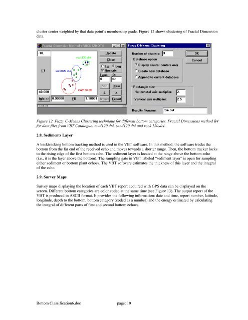
cluster center weighted by that data point’s membership grade. Figure 12 shows clustering of Fractal Dimension<br />
data.<br />
Figure 12. Fuzzy C-Means Clustering technique for different bottom categories. Fractal Dimensions method B4<br />
for data files from VBT Catalogue: mud120.dt4, sand120.dt4 and rock 120.dt4.<br />
2.8. Sediments Layer<br />
A backtracking bottom tracking method is used in the VBT software. In this method, the software tracks the<br />
bottom from the far end of the received echo and moves towards a shorter range. Then, the bottom tracker locks<br />
to the rising edge of the first bottom echo. The sediment layer is located at the range above the bottom echo<br />
(i.e., it is the layer above the bottom). The sampling gate in VBT labeled “sediment layer” is open for sampling<br />
either sediment or bottom plant echoes. The VBT software estimates the thickness of this layer and the integral<br />
of the echo.<br />
2.9. Survey Maps<br />
Survey maps displaying the location of each VBT report acquired with GPS data can be displayed on the<br />
screen. Different bottom categories are color coded at the same time (see Figure 13). The output report of the<br />
VBT is produced in ASCII format. It provides the following information: date and time, report number, latitude,<br />
longitude, depth to the bottom, bottom category (coded as a number) and the energy estimated by calculating<br />
the integral of different parts of first and second bottom echoes.<br />
<strong>Bottom</strong> <strong>Classification</strong>6.doc page: 10