

2008 Annual Monitoring Report (pdf 10.9MB) - Bolsa Chica ...
2008 Annual Monitoring Report (pdf 10.9MB) - Bolsa Chica ...
2008 Annual Monitoring Report (pdf 10.9MB) - Bolsa Chica ...

Create successful ePaper yourself
Turn your PDF publications into a flip-book with our unique Google optimized e-Paper software.
<strong>Bolsa</strong> <strong>Chica</strong> Lowlands Restoration <strong>Monitoring</strong><br />
<strong>2008</strong> <strong>Annual</strong> <strong>Report</strong><br />
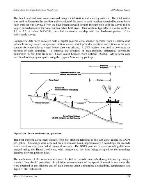
The beach and surf zone were surveyed using a total station and a survey rodman. The total station<br />
was used to determine the position and elevation of the beach at each location occupied by the rodman.<br />
Each transect was surveyed from the back beach seaward through the surf zone until the survey rod no<br />
longer protruded above the water surface when held erect. This location, typically in a water depth of<br />
3.0 to 3.5 m below NAVD88, provided substantial overlap with the landward portion of the<br />
bathymetric survey.<br />
Bathymetric data were collected with a digital acoustic echo sounder operated from a shallow-draft<br />
inflatable survey vessel. A dynamic motion sensor, which provides real-time corrections to the echo<br />
sounder for wave-induced vessel heave, also was utilized. A GPS receiver was used to determine the<br />
position of each sounding. To improve the accuracy of each position, differential corrections<br />
transmitted in real-time from U.S. Coast Guard beacons were utilized (DGPS). All systems were<br />
interfaced to a laptop computer using the Hypack Max survey package.<br />
Figure 2-10. Beach profile survey operations<br />
The boat traveled along each transect from the offshore terminus to the surf zone guided by DGPS<br />
navigation. Soundings were acquired on a continuous basis (approximately 3 soundings per second),<br />
while positions were recorded at 1-second intervals. The DGPS position data and sounding data were<br />
merged using the Hypack software, with interpolated positions being assigned to the soundings<br />
acquired between position fixes.<br />
The calibration of the echo sounder was checked at periodic intervals during the survey using a<br />
standard “bar check” procedure. In addition, measurements of the speed of sound in sea water also<br />
were obtained at the offshore end of each transect using a recording conductivity, temperature, and<br />
depth (CTD) instrument.<br />
Merkel & Associates, Inc. 119


