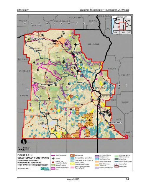
<strong>Siting</strong> <strong>Study</strong> <strong>Boardman</strong> <strong>to</strong> <strong>Hemingway</strong> <strong>Transmission</strong> <strong>Line</strong> <strong>Project</strong> 2.2.1 Constraints Geographically the study area comprises three general landscapes—agricultural areas, mountains, and high desert. Each has a unique set of constraints (see Figure 2.2.1-1) <strong>to</strong> be considered in identifying and evaluating feasible routes for development of a new transmission line. • Agricultural Areas—There are large agricultural areas throughout the study area. Morrow and Umatilla Counties include many farms with pivot irrigation as well as vast areas of dry agriculture, urban areas like <strong>Boardman</strong> and Pendle<strong>to</strong>n and smaller communities like Pilot Rock. Additionally, there are a growing number of wind farms, government-owned lands like the <strong>Boardman</strong> Bombing Range, his<strong>to</strong>ric resources like the Oregon National His<strong>to</strong>ric Trail, and habitat for protected species like the Oregon-listed endangered Washing<strong>to</strong>n ground squirrel. In the middle portion of the study there is considerable farming, much of which is irrigated in Baker and Union Counties. Development in these two counties has occurred around Baker City, La Grande, and a number of smaller communities. Both counties also include large mountainous areas and large tracts of National Forest. In the southern counties, including Malheur County, Oregon, and the Idaho portion of the study area, conditions are similar with much irrigated farmland and less dry agriculture in the Snake River Valley. There is also much more development, especially in Idaho counties, and I-84 is the major transportation corridor. A siting constraint unique <strong>to</strong> Oregon is the protection provided <strong>to</strong> Exclusive Farm Use (EFU) zones under Oregon law regarding utility facility siting. The Energy Facility <strong>Siting</strong> Council (EFSC) will not issue the necessary site certificate for a utility project sited on EFU-zoned lands unless reasonable alternatives have been considered and found unsuitable. • High Desert Areas—Areas of high desert extend across much of the southern half of the study area north and west in<strong>to</strong> Baker and Grant Counties. Much of the land is managed by the BLM and is designated as areas of critical environmental concern (ACECs), wilderness study areas (WSAs), and other special resource management areas. There are large areas of sage-grouse leks, associated 2-mile lek exclusion buffers, and sage-grouse habitat. There are a number of small cities and <strong>to</strong>wns but overall developed areas occupy a very small percentage of the high desert region. • Mountainous Areas—The mountainous areas such as the Blue Mountains have rugged <strong>to</strong>pography with many areas of steep slopes in excess of 35 percent and other areas of unstable slopes that present design and construction challenges. National Forests including the Wallowa-Whitman, Malheur, Umatilla, and Ochoco occupy much of the forested mountainous area. Some of the most challenging resource and/or land use constraints in these areas include wilderness areas, WSAs, wild and scenic rivers, special status streams, visual resource retention and preservation lands, and inven<strong>to</strong>ried roadless areas. Constraints were considered from both an environmental and a regula<strong>to</strong>ry perspective as well as from a community perspective. The CAP, discussed further in Section 2.6, allowed citizens <strong>to</strong> identify resources important <strong>to</strong> the communities, which may or may not fall under regula<strong>to</strong>ry guidance. Appendix B provides the community criteria collected from the five PATs during the CAP. 2.2.2 Opportunities In the study area, the most extensive opportunities are existing transmission lines and the utility corridors designated by the U.S. Department of Energy as West-wide Energy Corridors, the USFS, and the BLM. August 2010 2-3
<strong>Siting</strong> <strong>Study</strong> <strong>Boardman</strong> <strong>to</strong> <strong>Hemingway</strong> <strong>Transmission</strong> <strong>Line</strong> <strong>Project</strong> Figure 2.2.1-1. Selected Key Constraints August 2010 2-4