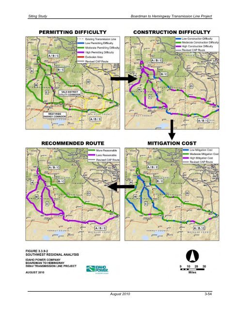
<strong>Siting</strong> <strong>Study</strong> <strong>Boardman</strong> <strong>to</strong> <strong>Hemingway</strong> <strong>Transmission</strong> <strong>Line</strong> <strong>Project</strong> Figure 3.3.9-2. Southwest Regional Analysis August 2010 3-54
<strong>Siting</strong> <strong>Study</strong> <strong>Boardman</strong> <strong>to</strong> <strong>Hemingway</strong> <strong>Transmission</strong> <strong>Line</strong> <strong>Project</strong> 3.3.10 Burnt River Region As shown in Figure 3.3.10-1, the Burnt River Region, located just west of the Idaho/Oregon state boundary, spans south from Pleasant Valley, Oregon, across the Baker County/Malheur County line <strong>to</strong> the <strong>to</strong>wn of Brogan, located along U.S. Highway 26. Severe <strong>to</strong>pography covers the region and includes the Burnt River Canyon, Pedro Mountain, California Mountain, and the Weatherby Mountains. Deer and elk winter range habitat is found throughout the region, while sage-grouse habitat grounds cover the southern portion. There is little agriculture and the few small <strong>to</strong>wns in the area can be found along I-84 at the eastern edge of the region and along the Snake River-Mormon Basin Back Country Byway that runs east-west across the central part of the region. In this region two routes identified in the central PAT meeting have been carried forward, revised, and are described below. The eastern route in the Burnt River Region is a revision of several CAP route segments, including C4, C8, C41, S9, and S19. Initially, revisions of these routes resulted in an East Route designated BA10- BA11-BA13-MA2. Spring 2010 field surveys identified an active sage-grouse lek site west of the I-84 corridor along the proposed route segment BA13-MA2. State regulations prohibit the siting of a transmission line within 2-miles of an active sage-grouse lek and therefore the route was shifted south <strong>to</strong> avoid the lek and buffer as shown on Figure 3.3.10-2. The revised East Route begins at BA10 and heads south following an existing 138-kV line along the north side of I-84. North of the Durkee Valley, the route turns east away from the existing 138-kV transmission line, passes approximately 1.2 miles east of the community of Durkee, Oregon, angles south and east around Gold Hill, and heads south past the communities of Weatherby and Dixie. The route then crosses <strong>to</strong> the west side of I-84 at the southern end of the Weatherby Mountains where it again meets with and parallels the west side of the 138-kV transmission line heading south. West of I-84 and a mile north of the <strong>to</strong>wn of Hunting<strong>to</strong>n, Oregon, the route angles south and west, past Limes<strong>to</strong>ne Butte, avoiding the sage-grouse lek and buffer and continuing across the Baker/Malheur County line in<strong>to</strong> Malheur County where it ends at MA2 approximately 2.5 miles west of the <strong>to</strong>wn of Brogan . The West Route in the Burnt River Region is a revision of CAP route S20 and a small portion of CAP route S21. These routes were revised <strong>to</strong> form the West Route in the region, designated BA10-BA20- MA1-MA2. Heading south from BA-10, the West Route crosses I-84 approximately 2 miles southeast of Pleasant Valley and heads southwest across severe slopes <strong>to</strong> the east of the Wallowa-Whitman National Forest. Continuing south, the West Route proceeds across the Burnt River Canyon, crosses the Snake River- Mormon Basin Back County Byway 4 miles east of the <strong>to</strong>wn of Bridgeport, Oregon, and passes <strong>to</strong> the west side of Shasta Butte and the Malheur Reservoir. After passing between Reservoir Butte and Cow Valley Butte, the West Route intersects and parallels an existing 69-kV transmission line and, after crossing U.S. Highway 26 three times, the route ends at MA2 located west of Brogan, Oregon. The permitting difficulty, construction difficulty, and mitigation cost analyses were performed on the West Route and the original East Route (BA10-BA11-BA13-MA2), as the analyses <strong>to</strong>ok place prior <strong>to</strong> identification of a new sage-grouse lek site (during the spring 2010 field survey) and the development of the revised East Route. The results of these analyses, shown on Figure 3.3.10-3 and in Table 3.3.10-1, along with Table D-10, Appendix D, show the two routes <strong>to</strong> be similar in permitting difficulty and the East Route slightly more difficult <strong>to</strong> construct. However, a helicopter flyover of potentially difficult engineering/construction areas, including the Burnt River Region, was performed by Idaho Power after desk<strong>to</strong>p analysis of the revised CAP routes and subsequent regional analyses. This aerial review indicated that construction and maintenance of a 500-kV line along the West Route, especially in the areas north and south of the Burnt River Canyon, would be exceptionally difficult and costly, mainly due <strong>to</strong> poor existing access and the extremely severe terrain. Based on this information, the original East Route was August 2010 3-55