Siting Study - Boardman to Hemingway Transmission Line Project
Siting Study - Boardman to Hemingway Transmission Line Project
Siting Study - Boardman to Hemingway Transmission Line Project

Create successful ePaper yourself
Turn your PDF publications into a flip-book with our unique Google optimized e-Paper software.
<strong>Siting</strong> <strong>Study</strong><br />
<strong>Boardman</strong> <strong>to</strong> <strong>Hemingway</strong> <strong>Transmission</strong> <strong>Line</strong> <strong>Project</strong><br />
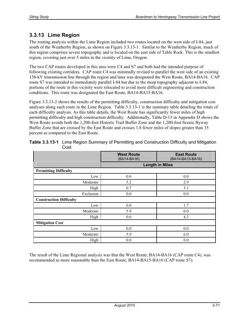
3.3.13 Lime Region<br />
The routing analysis within the Lime Region included two routes located on the west side of I-84, just<br />
south of the Weatherby Region, as shown on Figure 3.3.13-1. Similar <strong>to</strong> the Weatherby Region, much of<br />
this region comprises severe <strong>to</strong>pography and is located on the east side of Table Rock. This is the smallest<br />
region, covering just over 5 miles in the vicinity of Lime, Oregon.<br />
The two CAP routes developed in this area were C4 and S7 and both had the intended purpose of<br />
following existing corridors. CAP route C4 was minimally revised <strong>to</strong> parallel the west side of an existing<br />
138-kV transmission line through the region and later was designated the West Route, BA14-BA16. CAP<br />
route S7 was intended <strong>to</strong> immediately parallel I-84 but due <strong>to</strong> the steep <strong>to</strong>pography adjacent <strong>to</strong> I-84,<br />
portions of the route in this vicinity were relocated <strong>to</strong> avoid more difficult engineering and construction<br />
conditions. This route was designated the East Route, BA14-BA15-BA16.<br />
Figure 3.3.13-2 shows the results of the permitting difficulty, construction difficulty and mitigation cost<br />
analyses along each route in the Lime Region. Table 3.3.13-1 is the summary table detailing the <strong>to</strong>tals of<br />
each difficulty analysis. As this table details, the West Route has significantly fewer miles of high<br />
permitting difficulty and high construction difficulty. Additionally, Table D-13 in Appendix D shows the<br />
West Route avoids both the 1,200-foot His<strong>to</strong>ric Trail Buffer Zone and the 1,200-foot Scenic Byway<br />
Buffer Zone that are crossed by the East Route and crosses 1.8 fewer miles of slopes greater than 35<br />
percent as compared <strong>to</strong> the East Route.<br />
Table 3.3.13-1 Lime Region Summary of Permitting and Construction Difficulty and Mitigation<br />
Cost<br />
Permitting Difficulty<br />
Construction Difficulty<br />
Mitigation Cost<br />
West Route<br />
(BA14-BA16)<br />
East Route<br />
(BA14-BA15-BA16)<br />
Length in Miles<br />
Low 0.0 0.0<br />
Moderate 5.2 2.9<br />
High 0.7 3.1<br />
Exclusion 0.0 0.0<br />
Low 0.0 1.7<br />
Moderate 5.9 0.0<br />
High 0.0 4.3<br />
Low 0.0 0.0<br />
Moderate 5.9 6.0<br />
High 0.0 0.0<br />
The result of the Lime Regional analysis was that the West Route, BA14-BA16 (CAP route C4), was<br />
recommended as more reasonable than the East Route, BA14-BA15-BA16 (CAP route S7).<br />
August 2010 3-71