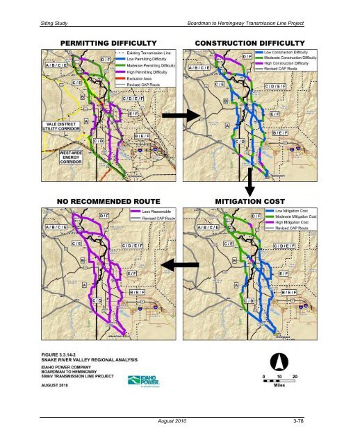
<strong>Siting</strong> <strong>Study</strong> <strong>Boardman</strong> <strong>to</strong> <strong>Hemingway</strong> <strong>Transmission</strong> <strong>Line</strong> <strong>Project</strong> Figure 3.3.14-2 shows the results of the permitting difficulty, construction difficulty, and mitigation cost analyses along each route. Table 3.3.14-1 summarizes the <strong>to</strong>tals of each difficulty analysis for each route while Table D-14 in Appendix D details the miles of each constraint crossed. Compared <strong>to</strong> Route C, Route D is 3.4 miles shorter and crosses less his<strong>to</strong>ric trail buffer, less deer and elk winter range, less big game critical winter habitat, less EFU, and less high erosion risk hazard soils. Route C crosses less sagegrouse key habitat (ID), less landslide hazard area, and fewer slopes over 25 percent, and also parallels more existing transmission lines and uses more miles of utility corridors. Overall, Routes C and D cross a similar number of miles of moderate and high permitting difficulty; however, Route D crosses 11.3 more miles of high difficulty construction. Route E (BA13-BA14-BA16-BA17-WA1-PA1-PA2-OW2) follows I-84 south <strong>to</strong> a location about 2 miles south of Hunting<strong>to</strong>n, Oregon (BA17) and then angles due east <strong>to</strong> cross the Snake River and the state line in<strong>to</strong> Idaho. From point WA1, Route E continues south and east in the steeper terrain north and east of Weiser, U.S. Highway 95, Payette, and the agricultural land along the east side of the Snake River. Continuing through point PA1 <strong>to</strong> PA2, this route remains on the north and east sides of the Payette River <strong>to</strong> a location just west of the Gem County line where it turns generally south and then west <strong>to</strong> cross the river and then I-84. This route then generally parallels I-84 almost <strong>to</strong> Caldwell where it angles west around the city and Lake Lowell. It continues southeast for about 12 miles along the east side of the Snake River where it crosses this river southeast of Rippee Island and then proceeds <strong>to</strong> the <strong>Hemingway</strong> Substation. Route F (BA13-WA1-PA1-PA2-OW2) follows portions of the paths of Routes D and E. From point BA13 <strong>to</strong> WA1, the route follows the path of Route D, proceeding east and south across Morgan Mountain and the Snake River (state line) in<strong>to</strong> Idaho. It continues east and south along the north side of Rock Creek and then turns south between Jenkins Creek and Sheep Creek until it joins Route E at point WA1. From WA1 <strong>to</strong> <strong>Hemingway</strong> Substation, Route F shares the same route as Route E as described above. As shown in Appendix D, Table D-14, Route F in comparison <strong>to</strong> Route E is 3.5 miles shorter and crosses less his<strong>to</strong>ric trail buffer, less deer and elk winter range, less big game critical winter habitat, less Sage grouse Core Area, less EFU, and less high erosion risk hazard soils. Route E crosses less sage-grouse key habitat (ID), less landslide hazard area, and fewer slopes over 25 percent and it parallels more existing transmission lines and uses more miles of utility corridors. Overall, Route F and Route E seem similar in difficulty <strong>to</strong> permit; however, Route F appears more difficult <strong>to</strong> construct. After completing the review of the alternative routes in the Snake River Valley Region as well as the alternative routes in the surrounding regions, it was decided that none of the six routes traversing this region should be recommended for further consideration. As shown on Figure 3.3.14-3, all of these routes would affect many farms and traverse 23.8 <strong>to</strong> 36.8 miles of irrigated farmlands. In Oregon all these routes cross some amount of EFU-zoned land. In Idaho the routes would pass in proximity <strong>to</strong> hundreds of residences and farms as well as urban and city impact areas. These are significant impacts and permitting issues that can be avoided by following routes <strong>to</strong> the west of Vale. August 2010 3-77
<strong>Siting</strong> <strong>Study</strong> <strong>Boardman</strong> <strong>to</strong> <strong>Hemingway</strong> <strong>Transmission</strong> <strong>Line</strong> <strong>Project</strong> Figure 3.3.14-2. Snake River Valley Regional Analysis August 2010 3-78