H-SAF Product Validation Report (PVR) PR-OBS-3
H-SAF Product Validation Report (PVR) PR-OBS-3
H-SAF Product Validation Report (PVR) PR-OBS-3

You also want an ePaper? Increase the reach of your titles
YUMPU automatically turns print PDFs into web optimized ePapers that Google loves.
<strong>Product</strong>s <strong>Validation</strong> <strong>Report</strong>, 30 May 2010 - <strong>PVR</strong>-03 (<strong>Product</strong> <strong>PR</strong>-<strong>OBS</strong>-3) Page 32<br />
Methods<br />
Satellite data are usually the raster data with defined projection and pixel size/resolution. Radar data are<br />
also raster data, but usually in a different projection and resolution from satellite data. Therefore the first<br />
step is to transform both data to the common projection and pixel resolution map optimal for data<br />
comparison. SHMÚ has good experiences how to perform necessary re-projections operationally.<br />
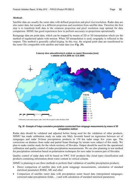
Raingauge data are point data, which can be mapped by means of 2D or 3D interpolation which use the<br />
method of regularised splain with tension. When 3D interpolation is used, orography is reflected in the<br />
outputs. This method is generally called kriging. In this way, the original point data are transformed to<br />
the raster file comparable with satellite and radar data (see Fig. 20).<br />
Fig. 20 - Example of 5-days cumulative precipitation constructed from raingauge measurements by means of 3D<br />
extrapolation method.<br />
Radar data should be validated and adjusted before being used for the validation of other products.<br />
SHMÚ has made calibration study on radar site Maly Javornik based on regression between set of<br />
raingauges and radar 24-hour precipitation products in 150 km radar range few years ago. The<br />
corrections on distance from radar and partial beam blockage by terrain were subject of this study. We<br />
plan to make similar study for the whole territory of Slovakia. Output should be used for the operational<br />
calibration and quality control of radar precipitation measurements. We are also planning to test method<br />
for precipitation estimation based on polarisation techniques for new radar in eastern part of Slovakia.<br />
Quality control of radar data will be based on NWC <strong>SAF</strong> products like cloud types classification and<br />
products containing information about water content in vertical column.<br />
SHMÚ is planning to use three methods to perform final validation of satellite precipitation products:<br />
Direct comparison of satellite data with point raingauge measurements, calculation of standard<br />
statistical parameters RMSE, ME and other.<br />
Comparison of satellite raster data with precipitation raster based data (interpolated raingauges,<br />
corrected radar precipitation fields,…) and with calculation of standard statistical parameters.