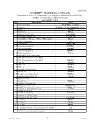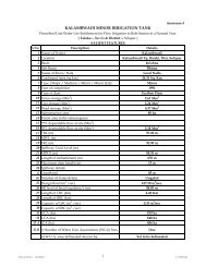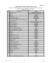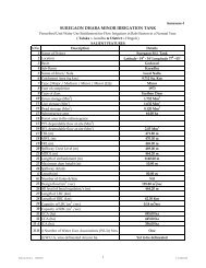
S.No. Description Data 1 Name of Project Andhera M I Tank 2 ...
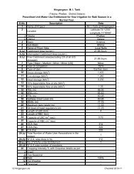
S.No. Description Data 1 Name of Project Andhera M I Tank 2 ...
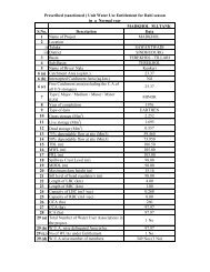
S.No. Description Data 1 Name of Project Andhera M I Tank 2 ...

Create successful ePaper yourself
Turn your PDF publications into a flip-book with our unique Google optimized e-Paper software.
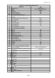
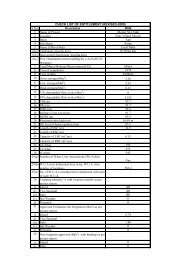
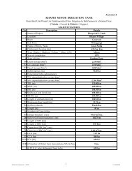
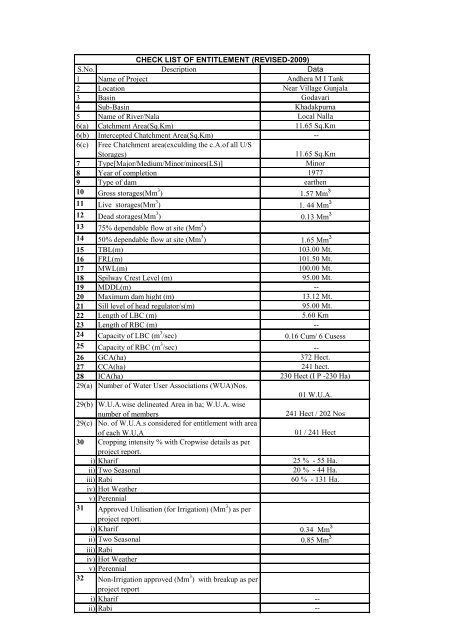
CHECK LIST OF ENTITLEMENT (REVISED-2009)<br />
S.<strong>No</strong>. <strong>Description</strong> <strong>Data</strong><br />
1 <strong>Name</strong> <strong>of</strong> <strong>Project</strong> <strong>Andhera</strong> M I <strong>Tank</strong><br />
2 Location Near Village Gunjala<br />
3 Basin Godavari<br />
4 Sub-Basin Khadakpurna<br />
5 <strong>Name</strong> <strong>of</strong> River/Nala Local Nalla<br />
6(a) Catchment Area(Sq.Km) 11.65 Sq.Km<br />
6(b) Intercepted Chatchment Area(Sq.Km) --<br />
6(c) Free Chatchment area(exculding the c.A.<strong>of</strong> all U/S<br />
Storages)<br />
11.65 Sq.Km<br />
7 Type[Major/Medium/Minor/minors(LS)] Minor<br />
8 Year <strong>of</strong> completion 1977<br />
9 Type <strong>of</strong> dam earthen<br />
10 Gross storages(Mm 3 ) 1.57 Mm 3<br />
11 Live storages(Mm 3 ) 1. 44 Mm 3<br />
12 Dead storages(Mm 3 ) 0.13 Mm 3<br />
13 75% dependable flow at site (Mm 3 )<br />
14 50% dependable flow at site (Mm 3 ) 1.65 Mm 3<br />
15 TBL(m) 103.00 Mt.<br />
16 FRL(m) 101.50 Mt.<br />
17 MWL(m) 100.00 Mt.<br />
18 Spilway Crest Level (m) 95.00 Mt.<br />
19 MDDL(m) --<br />
20 Maximum dam hight (m) 13.12 Mt.<br />
21 Sill level <strong>of</strong> head regulator/s(m) 95.00 Mt.<br />
22 Length <strong>of</strong> LBC (m) 5.60 Km<br />
23 Length <strong>of</strong> RBC (m) --<br />
24 Capacity <strong>of</strong> LBC (m 3 /sec) 0.16 Cum/ 6 Cusess<br />
25 Capacity <strong>of</strong> RBC (m 3 /sec) --<br />
26 GCA(ha) 372 Hect.<br />
27 CCA(ha) 241 hect.<br />
28 ICA(ha) 230 Hect (I P -230 Ha)<br />
29(a) Number <strong>of</strong> Water User Associations (WUA)<strong>No</strong>s.<br />
01 W.U.A.<br />
29(b) W.U.A.wise delineated Area in ha; W.U.A. wise<br />
number <strong>of</strong> members<br />
241 Hect / 202 <strong>No</strong>s<br />
29(c) <strong>No</strong>. <strong>of</strong> W.U.A.s considered for entitlement with area<br />
<strong>of</strong> each W.U,A<br />
01 / 241 Hect<br />
30 Cropping intensity % with Cropwise details as per<br />
project report.<br />
i) Kharif 25 % - 55 Ha.<br />
ii) Two Seasonal<br />
20 % - 44 Ha.<br />
iii) Rabi<br />
60 % - 131 Ha.<br />
iv) Hot Weather<br />
v) Perennial<br />
31 Approved Utilisation (for Irrigation) (Mm 3 ) as per<br />
project report.<br />
i) Kharif 0.34 Mm 3<br />
ii) Two Seasonal 0.85 Mm 3<br />
iii) Rabi<br />
iv) Hot Weather<br />
v) Perennial<br />
32 <strong>No</strong>n-Irrigation approved (Mm 3 ) with breakup as per<br />
project report<br />
i) Kharif --<br />
ii) Rabi --
iii) Hot Weather --<br />
33 <strong>No</strong>n-Irrigation actual (Mm 3 )<br />
i) Kharif --<br />
ii) Rabi --<br />
iii) Hot Weather --<br />
34 Seasonwise Evaporation Loss (Mm 3 )<br />
i) Kharif 0.082 Mm 3<br />
ii) Fair Weather 0.405 Mm 3<br />
iii) Total Annual<br />
0.487 Mcum<br />
35 Post Mansoon inflow(dry weather (Mm 3 )<br />
i) <strong>Project</strong> report --<br />
ii) Actual as per observation (preferred) --<br />
36 Reduction in the Reservoir due to Siltation in Mm 3<br />
i) Actual as per survey --<br />
ii) or as per formula (considering free catchment"6c")<br />
0.1118 Mm 3<br />
37 Any other commitment (2nd class<br />
irrigation,Malguzari rigths,Nastar rights etc, if any)<br />
--<br />
i) Kharif --<br />
ii) Rabi --<br />
iii) Hot Weather --<br />
38 Wather available calculation@canal head.<br />
i) water utilisation as per project report in Mm 3 1.44 Mm 3<br />
ii) deduct water utilisation for use in khrif Mm 3<br />
(31i+33i+34i+37i) 0.422 Mm 3<br />
iii) water available at the begining <strong>of</strong> Rabi (38i-38ii)<br />
Mm 3 1.018 Mm 3<br />
39 Deductions to get water available at the canal head<br />
--<br />
i) Deduct 34ii on 34iii as per utilisation porposed 0.405 Mm 3<br />
ii) Deduction for "Siltation (36i or ii) 0.1118 Mm 3<br />
iii) Deduction for fair weather non irrigation use (33ii or<br />
both 33ii+33iii) --<br />
iv) Deduction for any other commitment 37(ii +iii) --<br />
v) Water available at canal head before reservoir lift<br />
(38iii + 35ii-39(i+ii+iii+iv) 0.5012 Mm 3<br />
40 Decutions for Reservoir lift<br />
Reservoir Lift<br />
Case(A) where canal takes <strong>of</strong> directly from the<br />
reservaoir<br />
(a) Flow Lift<br />
i) Maximum Permissible Area 6% <strong>of</strong> CCA (ha) 14.46 ha.<br />
ii) Actual sanctioned area(ha)<br />
13.65 ha.<br />
iii) Maximum Allowable water allowance 3.6% <strong>of</strong> water<br />
available at canal head (Mm 3 ) i.e.39(v) 0.0180 Mm 3<br />
iv) Actual water allowance for sanctioned area<br />
=ii x 3.6 x water @canal head (39v) 0.0170 Mm 3<br />
i 100<br />
(b) Pressurised Lift (drip/sprinkler)<br />
i) Maximum Premissiable Area 14% <strong>of</strong> CCa (ha) 33.74 ha.<br />
ii) Actual sanctioned area (ha)<br />
6 ha.<br />
iii) Maximum allowable water allowance 5.65% <strong>of</strong><br />
water available at canal head (39v) (Mm 3 ) i.e.39(v)<br />
0.0283 Mm 3
iv) Actual water allowance for sanctioned area --<br />
=ii x 5.65 x water @canal head (39v) Mm 3 0.005 Mm 3<br />
i 100<br />
(c) Canal Lift (Outside command)<br />
i) Maximum Premissiable 10% (CCA-perennial area)<br />
(ha)<br />
ii) Actual sanctioned area(ha) --<br />
iii) Maximum Allowable water allowance for @ 7% <strong>of</strong><br />
water available at cvanal head (39v) (Mm 3 )<br />
iv) Actual water allowance for sanctioned area<br />
=ii x 7 x water @canal head (39v) Mm 3 --<br />
i 100<br />
41 Case(B) Where canal takes <strong>of</strong>f form the D/S <strong>of</strong><br />
pickup weir<br />
(a) Lift from dam storage<br />
i) Maximum Permissible area 1% <strong>of</strong> CCA (ha)<br />
ii) Actual sancationed area(ha)<br />
iii) Maximum Allowable water allowance 0.6% <strong>of</strong> water<br />
available at canal head (39v) (Mm 3 )<br />
iv) Actual water allowance for sanctioned area<br />
=ii x 0.6 x water @canal head (39v) Mm 3<br />
i 100<br />
(b) Pressurised Lift (drip/Sprinkler)<br />
i) Maximum Permissible area 14% <strong>of</strong> CCA (ha)<br />
ii) Actual sancationed area(ha)<br />
iii) Maximum Allowable water allowance 5.65% <strong>of</strong><br />
water available at canal head (39v) (Mm 3 )<br />
iv) Actual water allowance<br />
=ii x 5.65 x water @canal head (39v) Mm 3<br />
i 100<br />
(c) Lift on river portion between Dam to pickup weir<br />
i) Maximum Permissible area 5% <strong>of</strong> CCA (ha) NIL<br />
ii) Actual sancationed area(ha)<br />
iii) Maximum Allowable water allowance 3% <strong>of</strong> water<br />
available at canal head (39v) (Mm 3 )<br />
iv) Actual water allowance<br />
=ii x 3 x water @canal head (39v) Mm 3<br />
i 100<br />
d) Deduction for transit loss in the river portion in fair<br />
weather<br />
= 10% <strong>of</strong> water @ canal head<br />
(e) Deduction <strong>of</strong> water quantity for non-irrigation use in<br />
between the river portion (Between dam to pick up<br />
weir)<br />
(f) Canal Lift (Outside command)<br />
i) Maximum Permissible area 10% <strong>of</strong> [CCA -<br />
Perennial area ] (ha)<br />
ii) Actual sancationed area(ha)<br />
iii) Maximum Allowable water allowance 10% area @<br />
7% <strong>of</strong> water available at canal head (39v) (Mm 3 )<br />
iv) Actual water allowance<br />
=ii x 7 x water @canal head (39v) Mm 3<br />
i 100<br />
42 Net water available at canal head Mm 3<br />
A Case A (39v)-40(aiv+biv+civ) 0.4791 Mm 3
B Case B (39v)-41(aiv+biv+civ+d+e+fiv) --<br />
43 Net water available at canal head considering canal<br />
losses (Item <strong>No</strong> 42 x 0.80 or 0.90) Mm 3 0.3834 Mm 3<br />
Net water available for UWA = 42AX conveyance<br />
efficiency OR 42BX conveyance effciency<br />
44 Prescribed unit water use entitlement per ha <strong>of</strong><br />
C.C.A<br />
Case A (43 / 27 )Mm 3 / ha.<br />
Case B (43 / 27 )Mm 3 / ha.<br />
0.001732 Mm 3 /Ha.<br />
Delta 17.32 cm<br />
NB :- 6(b) intercepted Catchment Area incluses all storages and weirs in the catchment area the project.<br />
Executive Engineer<br />
Buldana Irrigation Division<br />
Buldana<br />
Superintending Engineer<br />
Akola Irrigation Circle<br />
Akola