a kayak - Wavelength Paddling Magazine
a kayak - Wavelength Paddling Magazine
a kayak - Wavelength Paddling Magazine

You also want an ePaper? Increase the reach of your titles
YUMPU automatically turns print PDFs into web optimized ePapers that Google loves.
The BC Marine Trail<br />
u Trail guide preview: how to run the whole WCVIN<br />
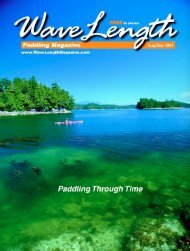
It was, in a word, a slog. I can find no<br />
better way to describe the run friend Carey<br />
Lockwood and I took down the yet-to-exist<br />
WCVIN in late August 2009. We battled<br />
our way down to Tofino against strong<br />
southerlies for most of the 15 days. My<br />
favorite coastal scenery was viewed mostly<br />
from a distance of a kilometer or more<br />
offshore to avoid the danger of high swell<br />
on hidden rocks. (We didn’t know at the<br />
time, but the unseasonal swell was residual<br />
from a storm off Hawaii).<br />
Regardless, it was a great adventure, with<br />
a few good days of serene paddling in the<br />
mix, particularly around the Bunsby Islands.<br />
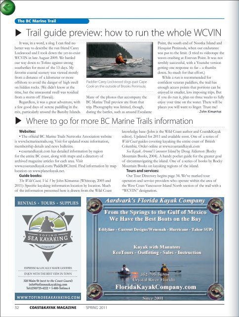
Paddler Carey Lockwood slogs past Cape<br />
Cook on the outside of Brooks Peninsula.<br />
Websites:<br />
• The official BC Marine Trails Networks Association website<br />
is www.bcmarinetrails.org. Visit for updated route information,<br />
membership details and news bulletins.<br />
• coastand<strong>kayak</strong>.com has detailed information by region<br />
for the entire BC coast, along with maps and a directory of<br />
archived magazine articles for each area. Visit<br />
www.coastand<strong>kayak</strong>.com/PaddleBC.html. Find information by map<br />
location on www.planet<strong>kayak</strong>.net.<br />
Guide books:<br />
The Wild Coast, Vol. 1 by John Kimantas (Whitecap, 2005 and<br />
2011): Specific <strong>kayak</strong>ing information location by location. Much<br />
of the information presented here is drawn from the Wild Coast<br />
Many of the photos that accompany the<br />
BC Marine Trail preview are from that<br />
trip. Photography was limited, though,<br />
during the battles, such as around Escalante<br />
Point, the south end of Nootka Island and<br />
Hesquiat Peninsula, when our endurance<br />
was put to the limit. (I tried to videotape the<br />
waves crashing at Estevan Point. It was not<br />
terribly successful, with a Youtube version<br />
getting one response so far – a thumbs<br />
down. So much for that effort.)<br />
While a run is recommended for<br />
confident veteran paddlers, the trail has<br />
enough access points that portions can be<br />
enjoyed in smaller, less imposing trips. But<br />
if you do run it, plan on three weeks to fully<br />
enjoy your time on the water. There will be<br />
places you will want to linger. Trust me!<br />
- John Kimantas<br />
u Where to go for more BC Marine Trails information<br />
knowledge base (John is the Wild Coast author and Coast&Kayak<br />
editor). Updated for 2011 and available soon. One of a series of<br />
Wild Coast guides covering <strong>kayak</strong>ing the entire coast of British<br />
Columbia. Order online at www.coastand<strong>kayak</strong>.com<br />
Sea Kayak Around Vancouver Island by Doug Alderson (Rocky<br />
Mountain Books, 2004). A handy pocket guide for the greater goal<br />
of circumnavigating the island. One of a series of books by Rocky<br />
Mountain Books on <strong>kayak</strong>ing regions of the island.<br />
Tours and services:<br />
Our Tour Directory begins page 34. We’ve marked tour<br />
operators and service providers who operate within the area of<br />
the West Coast Vancouver Island North section of the trail with a<br />
“WCVIN” designation.<br />
32 COAST&KAYAK MAGAZINE SPRING 2011