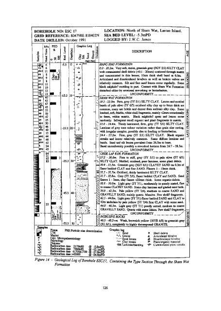
BOREHOLE NO: ESC 17GRID REFERENCE: 804798E 818402NDATE DRILLED: October 1991—a o.EOSC/3&0a:28-••«-sfiS—S3 «*d^-«««*****,~*A**t*«*tt~*M**A**A-***•*•^tf' -^0~*d«^a-^M*Mi«*l•MM*30*9*$0#£>90*9*90•v*srSr*0*00*9*90*9ieoq?¥S>0*0*€>©*£>*e>0J*S>0* —*#kPa1•a ccd6611898111012134042474555594725504640134440432445Samples@ 4)*e14 C 14C"c14 C~64~31458555Figure 14PSD%oSo ^ —, 1 . . 1 , , 1 . 1'Jl-slQoooo• 1:45.3Bi-K'tlWl12"8 c*-5.3-25.3-35.345.3-55.3Depth(m)30-4050Graphic Logij co c5? OFMCFMC»• j»-•&*" -'r-. ,}-_. *' r•".'"*•'.•":' \XXv«rXXie«"2 *! ,' ,' B 111 il 1 K\\\\\\\\\\\\1LOCATION: North of Sham Wat, Lantau Island.SEA BED LEVEL: -5.3raPDLOGGED BY: J.W.C. JamesDESCRIPTION0 _I/AJVG HA?/ FORMATION0.0 - m2m. Veiy soft, moist, greenish grey (5GY 5/1) SILTY CLAY&with comminuted sheE debris (disturbed either by erosional reworking or bioturbation.UNCONFORMITY•«£•SHAM WAT FORMATION102 - 22,0m. Firm, grey (5Y 5/1) SILTY CLAY. Lenses and mottledbands of pale olive (5Y 673) oxidised silty clay up to 8mm thick arecommon, many are brittle and denser than ambient silty cky. Some-leached, soft, friable, white shell fragments, mainly to 6mm, within matrix. Black sulphide? spots and lenses occurrandomly. Infrequent small organic and plant fragments in matrix.22.0 - 244m. Thinly laminated, firm, grey (5Y 5/1) SILTY CLAY.20-Laminae of grey tone colour variation rather than grain size sorting,- o- -with irregular margins, possibly due to loading or bioturbation.'.fo 1r^==-24,4 . 27.2m. Firm, grey (5Y 5/1) SILTY CLAY. Black organicJg I" TaSTstreaks and lenses relatively common. Some diffuse laminae andbands. Sand and silt lenses prevalent from 26.5m to base.^Basal unconformity possibly a reworked horizon from 26.7 - 28.5m.tt^ ___ UNCONFORMITYCHEK LAP KOK FORMATION272 - 30.8m. Firm to stiff, grey (5Y 5/1) to pale olive (5Y 6/3)SILTY CLAY. Mottled, oxidised, poor laminae, some plant debris.30.8 - 3L5m, Greenish grey (5GY 6/1) CLAYEY SAND on 0.3m offlaser bedded CLAY and fine SAND. Flasers 1 - 10mm thick.57.5 - 31.7m. Oxidised, thinly laminated SILTY CLAY.31.7-32.Bm, Grey (5 Y 5/1), flaser bedded CLAY and SAND. Sandflasers 1 - 3mm t clay flasers |•:'(' Sand * Shell debrisMazier %\ Gravel 4 Articulated bivalveUuc. Micropalaeontology "•"" Sand lenses £ Disarticulated bivalveE?2[^10^ "^ Clay lenses «° Plant/organic materialRadiocarbon date 2170±60 @ -5 8mPD ^ laminae/band irtg ^ Comminuted plant streaksRadiocarbon date 7960±85 @ -lilmPDRadiocarbon date 41700±1700 @ -17.8mPDRadiocarbon date >43000 @ -24,8mPD- Geological Log of Borehole ESC 17, Containing the Type Section Through the Sham WatFormationw oHOLOCENB1 1§231T>126
Sham Wat FormationThe Sham Wat Formation is a newly-defined formation (James, 1993; Fyfe & James, 1995),named after the locality of Sham Wat (0620 1500) on the northwest coast of Lantau Island. Thetype section of the formation is the continuously sampled Borehole ESC 17 (04798 18402)(Figure 14) located north of Sham Wat. The borehole sampled thick deposits of the Sham WatFormation which are overlain by Hang Hau Formation sediments and underlain by thick ChekLap Kok Formation sediments. At this site, the formation is bounded by reflectors interpreted aserosional unconformities. The borehole was sited on the intersection of two seismic lines, B35and B39, allowing the formations and their bounding unconformities to be traced north-south andeast-west. Borehole B2/1, to the north, and Borehole A5/1 (Figure 15), which lies to the east ofthe Soko Islands, also intersected these formations.The Sham Wat Formation is very restricted in its occurrence, with a total subcrop area of 96 km 2in the district. The most extensive deposits are confined to the west of the area, both northand south of Lantau Island (Figure 13). The formation is not exposed at sea bed, as it is alwaysoverlain by Hang Hau Formation sediments.The diagnostic morphology of the formation includes the form of its lower bounding surface. Inthis district, this distinctive lower surface has a high-density, deeply-channelled form (Figure 16).Channel separation varies from 35 to 150 m., with depths of less than 5 m to greater than 20 m.The floors of the channels may reach a level of-54 mPD. On seismic records, the channels aregenerally symmetrical in cross-section, commonly with deep, V-shaped forms and convexmargins. Because of the high channel density many of the channel interfluves are no more thanrounded humps, but in some areas they may be planar, with the line of an older erosion surfacediscernible across the interfluves. Conversely, the upper bounding surface is a planarsub-horizontal erosive contact, although some channelling at the base of the Hang Hau Formationhas occurred locally and this has incised the upper surface of the Sham Wat Formation.The channelled morphology of much of the Sham Wat Formation has controlled the distinctiveseismic character of the formation in this district. The primary reflector style is of continuous,sub-parallel units that drape over channel interfluves and down into channel deeps. In the deeperchannels the reflectors are parallel, U-shaped infills that onlap the channel margins and across theinterfluves. In some channels, especially the widest and deepest, there is evidence of reflectoroverlap and truncation due to erosion and current activity. A transparent, monotonous seismicresponse characterises the basal infill of some channels, but these are covered by thick sequencesof well-developed, parallel-draped reflectors. The draped nature of the sequence suggests thatconsolidation of the sediments occurred since initial deposition. Although some consolidation islikely, the absence of significant thinning between the principal reflectors over most channelmargins, suggests it is not the principal cause (James, 1993). The drapes are probably primaryphenomena resulting from siltation in shallow waters. The sub-parallel draping is generallycontinuous to the top of the formation, although there is some decrease in the amplitude of thedrapes.Few boreholes penetrate the thick sequences of the Sham Wat Formation around the Soko Islandsand north of Sham Wat, The most complete sequence proved is in the type borehole, ESC 17(Figures 13, 14 and 16), The formation comprises generally firm (undrained shear strength 40 -60 kPa), grey clayey silt. Lenses and mottled bands of brittle and denser, pale olive, oxidized,clayey silt up to 8 mm thick, arc common. Leached, soft and corroded white shell fragments,generally less than 2 mm, but occasionally up to 6 mm, occur and very small disarticulatedbivalves, up to 6 mm across, are also present. Black spots and lenses occur randomly, as doinfrequent, small, organic fragments. Within the upper part of the channel, at the base of the127
- Page 2 and 3:
UNIVERSITY OF HONG KONGLIBRARIES
- Page 4 and 5:
© Government of Hong KongPublished
- Page 7 and 8:
CONTENTSTitle pagePage1ForewordCont
- Page 9 and 10:
Distribution and Lithology 73Detail
- Page 11 and 12:
Chapter 10 Economic Geology 149Intr
- Page 13 and 14:
(Plates)Plate 22 - Porphyritic Medi
- Page 15:
Table 1 — Grain Size Description
- Page 18 and 19:
0 1 2 3 4 5 k mCONTOURS AT 100m INT
- Page 20 and 21:
properties of the marine deposits b
- Page 22 and 23:
Archival DataAll records from the s
- Page 24 and 25:
Chapter 2Outline of GeologyThe soli
- Page 26 and 27:
The Mesozoic volcanic rocks are div
- Page 29 and 30:
Chapter 3Palaeozoic Sedimentary Roc
- Page 31 and 32:
Carboniferous metasedimentaiy rocks
- Page 33 and 34:
Plate 1 - Fining-Upward Sequence of
- Page 35 and 36:
Plate 3 - Well-bedded Sandstones an
- Page 37 and 38:
Reef Island. The northern end of th
- Page 39 and 40:
Table 3. Evolution of Nomenclature
- Page 41 and 42:
are crudely stratified and welded i
- Page 43 and 44:
Shing Mun FormationThe type localit
- Page 45 and 46:
Tai Che Tung. Crystal tuff, interpr
- Page 47 and 48:
Plate 7 • Lapilli-Ash Crystal Tuf
- Page 49 and 50:
Plate 11 - Pyroclastic Breccia (086
- Page 51 and 52:
appears fragmental, and contains mu
- Page 53 and 54:
exposures in the stream bed consist
- Page 55 and 56:
Lin Fa Shan. The steep eastern flan
- Page 57 and 58:
dipping northwest at 46°, is prese
- Page 59 and 60:
Sunset Peak MemberThe Sunset Peak M
- Page 61 and 62:
Plate 16- Block and Lapilli-bearing
- Page 63 and 64:
Chapter 5Major IntrusionsClassifica
- Page 65 and 66:
in grain size from 0.4 to 1.5 mm, a
- Page 67 and 68:
20 - Megacrystic Medium-grained Gra
- Page 69 and 70:
Pui O Wan. Porphyritic medium-grain
- Page 71 and 72:
minimum age of c. 145 Ma (see earli
- Page 73 and 74:
The granite on Chek Lap Kok is most
- Page 75 and 76:
Southeast of Tin Sam, on the wester
- Page 77 and 78: About 1 km east of Nam Shan, exposu
- Page 79 and 80: Plate 25 - Thin Section of Porphyri
- Page 81 and 82: Chapter 6Minor IntrusionsIntroducti
- Page 83 and 84: The microgranite grades southwards
- Page 85 and 86: the Lantau Formation, however, and
- Page 87 and 88: Plate 29 - Flow-banded Quartzphyric
- Page 89 and 90: also cut volcanic rocks of the Tsue
- Page 91 and 92: Silver Mine Bay. On the headland so
- Page 93 and 94: Plate 33 - Core stone Development i
- Page 95: Plate 37 - Thin Section ofLamprophy
- Page 98 and 99: Pre-Yensfaanlan StructureWithin the
- Page 100 and 101: separates areas of different lithol
- Page 102 and 103: NeotectonicsFault activity in the r
- Page 105 and 106: Chapter 8Metamorphism and Alteratio
- Page 107 and 108: the majority of rocks in the distri
- Page 109: Chapter 9Superficial GeologyIntrodu
- Page 112 and 113: Detailstal O. Alluvial deposits for
- Page 114 and 115: trains. The regolith on most steep
- Page 116 and 117: Plate 44 - Boulder Debris on the So
- Page 118 and 119: gazetted for recreational purposes.
- Page 120 and 121: DetailsTai O. Extensive intertidal
- Page 122 and 123: Plate 48 - Sandy Beach at Fan Lau S
- Page 124 and 125: Pre-Chek Lap Kok Formation Deposits
- Page 126 and 127: formation. The sequence is usually
- Page 130 and 131: BOREHOLE NO: A5/1GRID REFERENCE: 80
- Page 132 and 133: formation, thinly laminated clays o
- Page 134 and 135: Quinqueloculina seminulum, which is
- Page 136 and 137: Channel and Transgressive Deposits.
- Page 138 and 139: Figure 20 - Areas of Acoustic Turbi
- Page 140 and 141: West Lamma Channel These may be att
- Page 142 and 143: Figure 23 - Depth-Averaged, Maximum
- Page 144 and 145: The formation is Holocene in age. T
- Page 146 and 147: Boreholes (A5/1, A5/2, B2/1, ESC17
- Page 148 and 149: Plate 51 - Deep Weathering Profile
- Page 151 and 152: Chapter 10Economic GeologyIntroduct
- Page 153 and 154: Non-metalliferous MineralsFissure v
- Page 155 and 156: REFERENCESAddison, R. (1986). Geolo
- Page 157 and 158: James, J.W.C. (1993). The offshore
- Page 159 and 160: Sewell, R.J., Strange, PJ., Langfor
- Page 161 and 162: Appendix 1Microfossils identified f
- Page 163 and 164: Appendix 2 (continued)Sample HK9913
- Page 165 and 166: Appendix 2 (continued)Sample HK1054
- Page 167 and 168: Appendix 4aSelective normalized pal
- Page 169 and 170: ,Appendix 5 -Radiocarbon and Other
- Page 171 and 172: construction materials 151contact m
- Page 173 and 174: molybdenite 149Mong Tung Hang 151Mo
- Page 175 and 176: talus 107,115Tarn Tsui Wan 71,87Tan
- Page 177: LB 555.125 G34 LGeology of Lantaii