TAP Field Report No. 5 A survey of Shetland's gallow hills Joris ...
TAP Field Report No. 5 A survey of Shetland's gallow hills Joris ...
TAP Field Report No. 5 A survey of Shetland's gallow hills Joris ...
- No tags were found...

You also want an ePaper? Increase the reach of your titles
YUMPU automatically turns print PDFs into web optimized ePapers that Google loves.
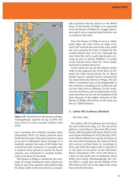
Gallow <strong>hills</strong> able quartzite outcrop, known as the WhiteStane <strong>of</strong> the Knowe <strong>of</strong> Wilga. It is separatedfrom the Knowe <strong>of</strong> Wilga by a boggy depressionand is not as exposed (and therefore notas visible) as the cairn.Since the Knowe <strong>of</strong> Wilga is set at a rathersteep slope, the vista covers an angle <strong>of</strong> almost160° towards the east <strong>of</strong> the cairn, whilethe view towards the west is limited by thenearby <strong>hills</strong>ide (Fig. 10 & 51). Although theview from the cairn is quite spectacular, coveringan area <strong>of</strong> almost 3000km², it mainlycovers distant areas, while the closer neighbourhoodis largely obscured.To the north, we can see the hilltops <strong>of</strong> Hoo<strong>Field</strong> on the opposite site <strong>of</strong> the Burn <strong>of</strong> Catpund,the latter being known for its <strong>No</strong>rsesteatite quarry. Catpund itself is obscured bythe slope below the Knowe <strong>of</strong> Wilga. The site<strong>of</strong>fers a wonderful view <strong>of</strong> Cunningsburgh tothe northeast, extending as far as Bressay andon clear days even to Whalsay. To the southeastwe see Mousa, and turning further in thesame direction we can see the headland <strong>of</strong> <strong>No</strong>Ness. Because <strong>of</strong> the higher elevation <strong>of</strong> theKnowe <strong>of</strong> Wilga, the horizon at the open sealies at c. 50km distance. 4) Gallow Hill, Scalloway, MainlandFigure 10 Viewshed from the Knowe <strong>of</strong> Wilga,Cunningsburgh. Legend: see ig. 4 (DTM: OrdnanceSurvey. © Crown copyright /database right2010).turn resembles the Icelandic monster Grýla(Jónasdóttir 2010: 21). Hence, both the storyitself and the name <strong>of</strong> its main character seemto be part <strong>of</strong> Shetland’s <strong>No</strong>rse heritage. It isdoubtful, whether the story <strong>of</strong> Kil Hulter hasa kernel <strong>of</strong> truth. However, it is possible, thata common story passed on across the <strong>No</strong>rsecolonies was connected to existing locales,such as the place <strong>of</strong> execution.The Knowe <strong>of</strong> Wilga is marked by the remnants<strong>of</strong> a large chambered cairn, which wasbuilt on top <strong>of</strong> the natural, rocky hillock (Fig.9). About 120m to the west, there’s a remark-HU 3991 3963The Gallow Hill <strong>of</strong> Scalloway lies directly tothe west <strong>of</strong> the town (Fig. 11). The site <strong>of</strong> the<strong>gallow</strong>s is described as ‘the west hill <strong>of</strong> Scallowaycallit the <strong>gallow</strong> hill abone Houll’ in thecourt book <strong>of</strong> Shetland in 1615 (Barclay 1967:116). (Wester)Houll was a group <strong>of</strong> houses onthe west side <strong>of</strong> Scalloway, the name <strong>of</strong> whichstill survives in Houl Road. In recordings <strong>of</strong>1616 and 1625 the Gallow Hill is referred toas ‘the place <strong>of</strong> execution’ on the ‘hill aboveBerrie’ (Donaldson 1991: 43 & 124). Berry isa farm on the north side <strong>of</strong> Scalloway, about500m from Houll. Morphologically, the GallowHill is a small spur on the <strong>hills</strong>ide <strong>of</strong> theHill <strong>of</strong> Berry (103 m), at the edge <strong>of</strong> the steepbase towards the town.11