<strong>TAP</strong> <strong>Field</strong> <strong>Report</strong> <strong>No</strong>. 5Figure 11 Topography <strong>of</strong> Gallow Hill, Scalloway.(Data: Ordnance Survey. © Crown copyright/database right 2010).According to local residents, there is a lowknoll <strong>of</strong> reddish soil about 100 yards west <strong>of</strong>the television mast on Gallow Hill. 7 The soilappears to be burnt, and local tradition has itthat this was the stake <strong>of</strong> the last witch burnings.8 In an internet forum thread on Shetland’s<strong>gallow</strong>s sites, one user commented thatthe burnt spot may be much younger and mayhave been caused by bonires held during theannual Scalloway Gala until the 1990s. 9 Yet,the spot seems to have been known to localsfor quite a long time. Indeed, the court booksshow that several women, who had been accused<strong>of</strong> witchcraft, were strangled and burntat the Gallow Hill, while the male convictswere usually hanged. The hill to the southwest<strong>of</strong> Scalloway, on the Ness <strong>of</strong> Westshore,is known as Witch’s Hill. The name appearsin J.G. Bartholomew’s Survey Atlas <strong>of</strong> Scotland<strong>of</strong> 1912 10 and the half inch to the milemap <strong>of</strong> Shetland issued in 1926 by the samepublisher. 11Be this as it may, the place on Gallow Hill,which apparently shows traces <strong>of</strong> a majorire, is not particularly visible from Scallowayor the surrounding coastal area. Since we mayassume that visibility was a major factor forthe location <strong>of</strong> the <strong>gallow</strong>s, they may havebeen located closer to the steep drop on the<strong>hills</strong>ide above Scalloway. There is a naturalknoll on this side <strong>of</strong> the hill, which <strong>of</strong>fers anexcellent view <strong>of</strong> the town and the adjacentvalley. The panoramic photo was taken fromhere.The viewshed (Fig. 12) represents the combinedviewsheds from two observer pointsspaced 30m apart to overcome obstructionsat the edges <strong>of</strong> DTM grid cells. The cumulativeviewshed corresponds better to the actualvista shown on the panoramic photograph(Fig. 52).The area, which can be seen from this spot,is much smaller than at the sites discussedbefore. This is mainly due to the fact, that itis not possible to see the open sea from herein any direction, but the visible land surfaceis deinitely smaller too. The view towardsthe west and northwest is largely obscuredby the up-sloping <strong>hills</strong>ide <strong>of</strong> the Hill <strong>of</strong> Berry.Towards the northeast, we see Tingwall Valley,with Veensgarth and Laxirth in the distance.Towards the east, the site overlooksScalloway, with the Hill <strong>of</strong> Easterhoull behindit. The site <strong>of</strong>fers the best vista towards the Figure 12 Viewshed from Gallow Hill, Scalloway.Legend: see ig. 4 (DTM: Ordnance Survey. ©Crown copyright /database right 2010).12
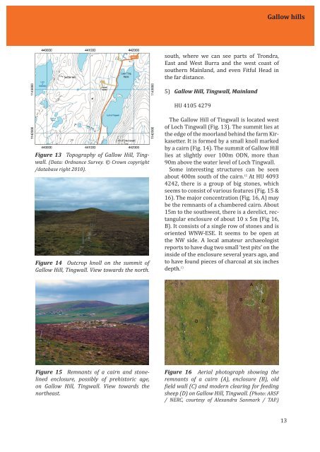
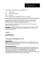
Gallow <strong>hills</strong>south, where we can see parts <strong>of</strong> Trondra,East and West Burra and the west coast <strong>of</strong>southern Mainland, and even Fitful Head inthe far distance.5) Gallow Hill, Tingwall, MainlandHU 4105 4279Figure 13 Topography <strong>of</strong> Gallow Hill, Tingwall.(Data: Ordnance Survey. © Crown copyright/database right 2010).Figure 14 Outcrop knoll on the summit <strong>of</strong>Gallow Hill, Tingwall. View towards the north.The Gallow Hill <strong>of</strong> Tingwall is located west<strong>of</strong> Loch Tingwall (Fig. 13). The summit lies atthe edge <strong>of</strong> the moorland behind the farm Kirkasetter.It is formed by a small knoll markedby a cairn (Fig. 14). The summit <strong>of</strong> Gallow Hilllies at slightly over 100m ODN, more than90m above the water level <strong>of</strong> Loch Tingwall.Some interesting structures can be seenabout 400m south <strong>of</strong> the cairn. 12 At HU 40934242, there is a group <strong>of</strong> big stones, whichseems to consist <strong>of</strong> various features (Fig. 15 &16). The major concentration (Fig. 16, A) maybe the remnants <strong>of</strong> a chambered cairn. About15m to the southwest, there is a derelict, rectangularenclosure <strong>of</strong> about 10 x 5m (Fig 16,B). It consists <strong>of</strong> a single row <strong>of</strong> stones and isoriented WNW-ESE. It seems to be open atthe NW side. A local amateur archaeologistreports to have dug two small ‘test pits’ on theinside <strong>of</strong> the enclosure several years ago, andto have found pieces <strong>of</strong> charcoal at six inchesdepth. 13ABCDFigure 15 Remnants <strong>of</strong> a cairn and stonelinedenclosure, possibly <strong>of</strong> prehistoric age,on Gallow Hill, Tingwall. View towards thenortheast.Figure 16 Aerial photograph showing theremnants <strong>of</strong> a cairn (A), enclosure (B), oldield wall (C) and modern clearing for feedingsheep (D) on Gallow Hill, Tingwall. (Photo: ARSF/ NERC, courtesy <strong>of</strong> Alexandra Sanmark / <strong>TAP</strong>.)13