TAP Field Report No. 5 A survey of Shetland's gallow hills Joris ...
TAP Field Report No. 5 A survey of Shetland's gallow hills Joris ...
TAP Field Report No. 5 A survey of Shetland's gallow hills Joris ...
- No tags were found...

Create successful ePaper yourself
Turn your PDF publications into a flip-book with our unique Google optimized e-Paper software.
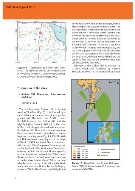
<strong>TAP</strong> <strong>Field</strong> <strong>Report</strong> <strong>No</strong>. 5Figure 3 Topography <strong>of</strong> Gallow Hill, Huesbreck.The little star marks the viewshed’s observerpoint (see ig. 4). (Data: Ordnance Survey.© Crown copyright /database right 2010).Forra Ness are visible in the distance, with asmall stripe <strong>of</strong> the Atlantic behind them. Thebest land view from Gallow Hill is towards thenorth, where it overlooks almost all the landbetween the observer and the Ward <strong>of</strong> Scousburgh(263 m), located 4.5km to the north. Tothe northeast, one can see the settlements <strong>of</strong>Boddam and Dalsetter. To the east, the Loch<strong>of</strong> Browbreck is visible in the foreground, andwe have a grand view <strong>of</strong> the <strong>No</strong>rth Sea, withthe horizon at a distance <strong>of</strong> c. 30km. However,the coast itself, which is about 850m from thetop <strong>of</strong> Gallow Hill, and the voe below Boddamare obscured by the slope.The top <strong>of</strong> the Gallow Hill is marked bya cairn, which was scheduled by HistoricScotland in 1975. 5 It is surrounded by other, Discussion <strong>of</strong> the sites1) Gallow Hill, Huesbreck, Dunrossness,MainlandHU 3929 1443The southernmost Gallow Hill is locatedsouth <strong>of</strong> Boddam (Fig. 3). It is formed by asmall hillock at the east side <strong>of</strong> a larger butgradual hill. The main road A 970 crossesthe hill between the Gallow Hill and theslightly higher ‘summit’ (68 m) to the west<strong>of</strong> the road. Despite its moderate elevation,the Gallow Hill <strong>of</strong>fers a ine view <strong>of</strong> southernDunrossness and can in return be seen from alarge surrounding area (Fig. 4 & 49). The GallowHill overlooks the valley up to the ridge<strong>of</strong> Ward Hill (80 m), about 2km to the south,with the top <strong>of</strong> the Compass <strong>of</strong> Sumburgh justvisible behind it. The West Voe <strong>of</strong> Sumburgh,opening out into the Atlantic Ocean, appearsto the southwest, adjaced by Fitful Head.However, since the land continues to slopeup in this direction for about 350 m, the landlying between the top <strong>of</strong> the hill and the landscapefeatures mentioned before is largelyobscured. To the <strong>No</strong>rthwest, Loch Spiggie and Figure 4 Viewshed from Gallow Hill, Huesbreck.(DTM: Ordnance Survey. © Crown copyright/database right 2010).8