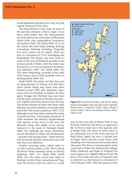
<strong>TAP</strong> <strong>Field</strong> <strong>Report</strong> <strong>No</strong>. 5lieved Shetland’s parishes to be ‘very, very oldindeed’ (Clouston 1914: 432).The thing-element in the name <strong>of</strong> some <strong>of</strong>the parishes indicates a <strong>No</strong>rse origin. It hasbeen noted before that the thing-parishesare all located in the central part <strong>of</strong> Mainland,which lacks clear geographical boundaries(Donaldson 1958: 130. Smith 2009: 41 f.). Tothe names still used today (Delting, Nesting,Lunnasting, Aithsting, Sandsting, Tingwall),two more names can be added, which appearin a document <strong>of</strong> 1321: Þvæitaþing andRauðarþing. The former may have been locatedin the west <strong>of</strong> Shetland, possibly in thepresent parish <strong>of</strong> Walls, while the latter mayhave been in, or even correspond to <strong>No</strong>rthmavine(Jakobsen 1897: 102. Smith 2009: 42).The name Neipnating, recorded in the early16th century and in 1628, probably refers toNesting (Smith 2009: 41).Smith (2009: 42) points out that there areno thing-parishes in Orkney, and that Shetland’sparish things may hence have beenformed around 1300, after Shetland’s separationfrom the Earldom <strong>of</strong> Orkney. He doesagree, though, that Shetland may once havehad the same, symmetrical division into quarters,eighths and thirds known from <strong>No</strong>rway.The former division <strong>of</strong> Fetlar into three smalldistricts was still recalled by a local lady at theend <strong>of</strong> the 19th century (Jakobsen 1897: 117),although it must have been outdated for manycenturies by then. A <strong>No</strong>rwegian document <strong>of</strong>1490 mentions the districts Vogaiordwngh(‘the quarter <strong>of</strong> the voes’) in the west andMawedes otting (‘the eighth at the narrowisthmus’) in the north <strong>of</strong> Shetland (Smith2009: 43). Although the names themselvescan be identiied as Walls and <strong>No</strong>rthmavine– parishes still existing today – Smith stressesthat the parish division and borders may stillhave been very different.Another recurring name, which refers toan older judicial system, is the ‘Herra’ (fromOld <strong>No</strong>rse hérað, meaning county or disrict)(Jakobsen 1897: 117. Smith 2006. Smith2009: 43). The name occurs four times inShetland: in Yell, Fetlar, Lunnasting and Tingwall.The Herra in Yell now refers to a small Figure 45 Location <strong>of</strong> ‘ting-’ and ‘herra’-placenames and <strong>gallow</strong> <strong>hills</strong> (see ig. 44 for legend).Marked sites: 1 Tingwall; 2 Sand; 3 Aith; 4 Neap; 5Lunna; 6 Dale; 7 Herra, Lunnasting; 8 Herra, Fetlar;9 Herra, Yell.area on the west side <strong>of</strong> Whale Firth. It wasformerly called the ‘Oot Herra’, as opposed tothe ‘In Herra’, which lay at the opposite side<strong>of</strong> Whale Firth. The Herra in Fetlar refers tothe settlement area to the north and east <strong>of</strong>Papil Water. Again, the area is divided intoan Upper Herra and the Lower Herra, eachincluding a few farmsteads and located about1km apart. The Herra in Lunnasting lies at thesouth end <strong>of</strong> Vidlin Voe, between the villagesVidlin, Gillsbreck and Orgill. In Tingwall, thename appears in a slightly different form: thearea to the north and west <strong>of</strong> Tingwall Lochis referred to as the Harray in a document <strong>of</strong>1525 (Stewart 1987: 130). The name survives30
Gallow <strong>hills</strong>as Herrisdale (Park) and Herrislea (House /Hill) in Veensgarth.It is generally assumed that the old thingparishes,as well as the héruð each had theirown, local assembly. The only assembly sitewhich can be located with some certainty is atTingwall (from Old <strong>No</strong>rse Þingvöllr, ‘the ields<strong>of</strong> the parliament’). According to the tradition,the assembly met at the islet called Law TingHolm, at the north side <strong>of</strong> the lake (Coolen &Mehler 2010: 6-9). There is a very close spatialrelationship between the assembly site,the parish church and the Gallow Hill: theholm is located only 340m from the churchand exactly 1km from the summit <strong>of</strong> GallowHill.It seems logical to believe that the localassemblies <strong>of</strong> Delting, Nesting, Lunnasting,Aithsting and Sandsting were held in theDale, Neap, Lunna, Aith and Sand respectively(Smith 2009: 41). Sand and Lunna each hosta Medieval parish church, while Neap is atleast close to the former parish church <strong>of</strong>Kirkabister. There are old church sites in Aithand Dale too, but they are not documented asparish churches. However, none <strong>of</strong> these allegedthing-sites is close to any <strong>of</strong> the <strong>gallow</strong>ssites (Fig. 45). As for the herra-names, thereis an interesting association <strong>of</strong> the Herra witha parish church and a Gallow Hill in Fetlar, allbeing located within 2km from each other.The Herra in Mid Yell is about 3km from Holsigarth,but as said, this site is very dubious.Although there are several pre-Reformationchapel and church sites known in the vicinity,none <strong>of</strong> them is recorded as a parish church.The same applies to the chapel site in Vidlin,which is located about 0.5km from the Herrain Lunnasting.One could argue that the places <strong>of</strong> executionmight have been located near the boundary<strong>of</strong> a judicial district rather than close to thecourt site. In Medieval and Early Modern Europe,<strong>gallow</strong>s were <strong>of</strong>ten erected near districtboundaries for both practical and symbolicreasons (e.g. Piech 2010: 314. Mol 2007, 281ff.). Reynolds (2009, 219-27) has describedthe strong association between Anglo-Saxonexecution cemeteries and Early Medievalhundred boundaries. Since we know littleabout the Medieval parish division <strong>of</strong> Shetland,it is almost impossible to reconstructthe parish boundaries. However, no matterwhere the boundaries were, the area betweenthe alleged thing-sites mentioned above iscompletely devoid <strong>of</strong> known <strong>gallow</strong>s sites. Ofthe present thing-parishes, only Tingwall andDelting include a <strong>gallow</strong>s site. Although theformer is close to the border <strong>of</strong> Whiteness, itdoes not overlook any access route betweenthe two parishes. Moreover, Whiteness is nothing-parish. The Gallow Hill <strong>of</strong> Brae in Deltingseems more convincing: it is close to theborder <strong>of</strong> <strong>No</strong>rthmavine, and everybody whowould cross Mavis Grind and the wider isthmus<strong>of</strong> Brae would have been confronted withthe sight <strong>of</strong> the <strong>gallow</strong>s.There is, however, an interesting relationshipbetween the <strong>gallow</strong>s sites and post-Medieval parish borders (Fig. 46). The latterwere taken from a modern map showing theparishes listed in the Old Statistical Account(1791-99). 31 Alternatively, the parishes canalso be modelled based on the descriptions<strong>of</strong> Pitcairn and Brand and the location <strong>of</strong> Medievalparish churches. Assuming that eachparish church lies more or less in the centre<strong>of</strong> its associated parish, the parishes can bemodelled as Thiessen polygons (Fig. 47). Ofcourse this is a highly theoretical and perhapssimplistic approach, since it does not accountfor the actual geography. Surely, the actualdivision was more complex. However, theThiessen polygons show strong similaritieswith the parishes listed in the Old StatisticalAccount, and as long as we acknowledge thetheoretical character <strong>of</strong> this approach, thereseems to be some justiication for it.At irst sight it seems striking that there isnever more than one <strong>gallow</strong>s site per parish,except in the already discussed case <strong>of</strong>Tingwall. However, this is simply a consequence<strong>of</strong> the already discussed correlationbetween the <strong>gallow</strong>s sites and Medieval parishchurches. The Thiessen polygons show31