TAP Field Report No. 5 A survey of Shetland's gallow hills Joris ...
TAP Field Report No. 5 A survey of Shetland's gallow hills Joris ...
TAP Field Report No. 5 A survey of Shetland's gallow hills Joris ...
- No tags were found...

You also want an ePaper? Increase the reach of your titles
YUMPU automatically turns print PDFs into web optimized ePapers that Google loves.
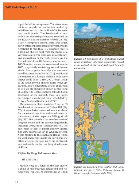
<strong>TAP</strong> <strong>Field</strong> <strong>Report</strong> <strong>No</strong>. 5top <strong>of</strong> the hill forms a plateau. The actual summitis not very distinctive, but it is marked byan OS benchmark. It lies at 99m ODN, betweentwo small ponds. The benchmark standswithin an interesting structure, recorded bythe RCAHMS as site number HP50SE 23 (Fig.34). 25 It comprises several small and larger,partly interconnected circular drystone walls.According to the RCAHMS database, this isa look-out shelter, built from the stones <strong>of</strong> avery large cairn. The cairn was subject to severalexcavations in the 19th century. As theirst edition <strong>of</strong> the OS Country Map series 1:10,560 notes, stone cists were found here in1825, apparently containing several humanskulls. Fourty years later, the site was excavatedby James Hunt (Smith 2011), who foundthe remains <strong>of</strong> a human skeleton with somelimpet shells (Hunt 1866, 297). About 100mto the south, there is another cairn, which apparentlyalso yielded stone cists in 1825. Nextto it is an old sheepfold known as the Pund<strong>of</strong> Gallow Hill. On the southern <strong>hills</strong>ide, 650msouthwest <strong>of</strong> the summit, there is a large,heel-shaped chambered cairn scheduled byHistoric Scotland (index nr. 7667). 26The panoramic photo was taken from the OSbenchmark at the summit <strong>of</strong> Gallow Hill (Fig.57). A cumulative viewshed was calculatedfor the summit and four additional points atthe corners <strong>of</strong> the respective DTM grid cell(Fig. 35). The site <strong>of</strong>fers an excellent view <strong>of</strong>Colgrave Sound and the surrounding islands,including Uyea, Fetlar, Hascosay and Yell. Theeast coast <strong>of</strong> Yell is almost entirely visible.The view reaches as far as Whalsay or even<strong>No</strong>rth Nesting to the south and Ronas Hill tothe west and across Unst to the north. The site<strong>of</strong>fers a view <strong>of</strong> the open sea to the northwest,east and south, the horizon lying at a distance<strong>of</strong> 40km.Figure 34 Remnants <strong>of</strong> a prehistoric burialcairn on Gallow Hill, Unst, apparently reusedas an outlook shelter and destroyed by earlyexcavation . 13) Muckle Heog, Baltasound, UnstHP 6315 1081 Muckle Heog is a knoll on the east side <strong>of</strong>a chain <strong>of</strong> <strong>hills</strong> between Baltasound and Haroldswick(Fig. 36). Its summit lies at 140mFigure 35 Viewshed from Gallow Hill, Unst.Legend: see ig. 4 (DTM: Ordnance Survey. ©Crown copyright /database right 2010).22