TAP Field Report No. 5 A survey of Shetland's gallow hills Joris ...
TAP Field Report No. 5 A survey of Shetland's gallow hills Joris ...
TAP Field Report No. 5 A survey of Shetland's gallow hills Joris ...
- No tags were found...

You also want an ePaper? Increase the reach of your titles
YUMPU automatically turns print PDFs into web optimized ePapers that Google loves.
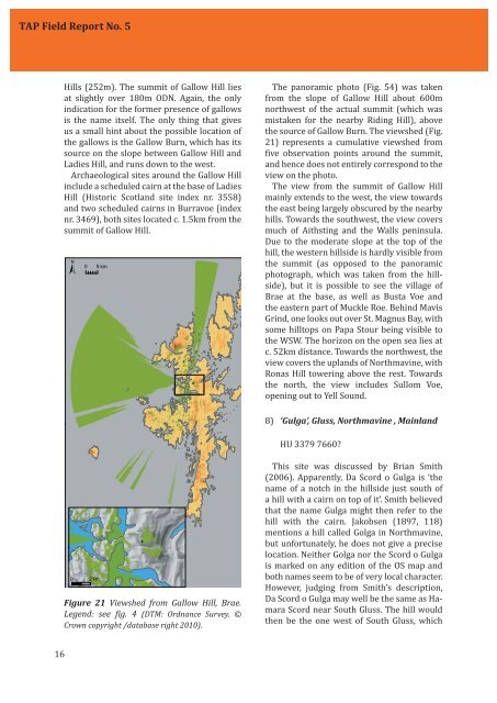
<strong>TAP</strong> <strong>Field</strong> <strong>Report</strong> <strong>No</strong>. 5Hills (252m). The summit <strong>of</strong> Gallow Hill liesat slightly over 180m ODN. Again, the onlyindication for the former presence <strong>of</strong> <strong>gallow</strong>sis the name itself. The only thing that givesus a small hint about the possible location <strong>of</strong>the <strong>gallow</strong>s is the Gallow Burn, which has itssource on the slope between Gallow Hill andLadies Hill, and runs down to the west.Archaeological sites around the Gallow Hillinclude a scheduled cairn at the base <strong>of</strong> LadiesHill (Historic Scotland site index nr. 3558)and two scheduled cairns in Burravoe (indexnr. 3469), both sites located c. 1.5km from thesummit <strong>of</strong> Gallow Hill. The panoramic photo (Fig. 54) was takenfrom the slope <strong>of</strong> Gallow Hill about 600mnorthwest <strong>of</strong> the actual summit (which wasmistaken for the nearby Riding Hill), abovethe source <strong>of</strong> Gallow Burn. The viewshed (Fig.21) represents a cumulative viewshed fromive observation points around the summit,and hence does not entirely correspond to theview on the photo.The view from the summit <strong>of</strong> Gallow Hillmainly extends to the west, the view towardsthe east being largely obscured by the nearby<strong>hills</strong>. Towards the southwest, the view coversmuch <strong>of</strong> Aithsting and the Walls peninsula.Due to the moderate slope at the top <strong>of</strong> thehill, the western <strong>hills</strong>ide is hardly visible fromthe summit (as opposed to the panoramicphotograph, which was taken from the <strong>hills</strong>ide),but it is possible to see the village <strong>of</strong>Brae at the base, as well as Busta Voe andthe eastern part <strong>of</strong> Muckle Roe. Behind MavisGrind, one looks out over St. Magnus Bay, withsome hilltops on Papa Stour being visible tothe WSW. The horizon on the open sea lies atc. 52km distance. Towards the northwest, theview covers the uplands <strong>of</strong> <strong>No</strong>rthmavine, withRonas Hill towering above the rest. Towardsthe north, the view includes Sullom Voe,opening out to Yell Sound.8) ‘Gulga’, Gluss, <strong>No</strong>rthmavine , MainlandHU 3379 7660? Figure 21 Viewshed from Gallow Hill, Brae.Legend: see ig. 4 (DTM: Ordnance Survey. ©Crown copyright /database right 2010).This site was discussed by Brian Smith(2006). Apparently, Da Scord o Gulga is ‘thename <strong>of</strong> a notch in the <strong>hills</strong>ide just south <strong>of</strong>a hill with a cairn on top <strong>of</strong> it’. Smith believedthat the name Gulga might then refer to thehill with the cairn. Jakobsen (1897, 118)mentions a hill called Golga in <strong>No</strong>rthmavine,but unfortunately, he does not give a preciselocation. Neither Golga nor the Scord o Gulgais marked on any edition <strong>of</strong> the OS map andboth names seem to be <strong>of</strong> very local character.However, judging from Smith’s description,Da Scord o Gulga may well be the same as HamaraScord near South Gluss. The hill wouldthen be the one west <strong>of</strong> South Gluss, which16