flood plain information south creek, north creek, catfish - Sarasota ...
flood plain information south creek, north creek, catfish - Sarasota ...
flood plain information south creek, north creek, catfish - Sarasota ...

Create successful ePaper yourself
Turn your PDF publications into a flip-book with our unique Google optimized e-Paper software.
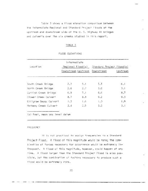
Table 3 shows a <strong>flood</strong> elevation comparison betweenthe Intermdiate Reqional and Standard Project Floods at theupstream and downstream side of the U. S. Highway 41 bridgesand culverts over the six <strong>creek</strong>s studied in this report.TABLE 3FLOODELEVATIONSLocationIntermediateRegional Flood(al Standard Project Flood(alDownstream Upstream Downstream UpstreamSouth Creek Bridge 2.7 5. I 3.3 6.1North Creek Bridge 2.6 2.7 3.0 3. ICatfish Creek Bridge 6.9 7. I 8.6 8.7Clower Creek Culvert 8.7 8.8 9.2 9.3EI Ii graw Bayou Culvert 1.3 1.6 1.3 I .9Matheny Creek Culvert 2.4 2.5 3.0 3. I(a 1 Feet, mean sea level datumFREOUE~ICYIT is not practical to assign frequencies to a StandardProject Flood. A <strong>flood</strong> of this magnitude would be rare; the combinationof forces necessary for occurrence would be extremely infrequent.A <strong>flood</strong> of this magnitude, however, could happen at anytime. A <strong>flood</strong> larger than the Standard Project Flood is also possible,but the combination of factors necessary to produce such a<strong>flood</strong> would be extremely rare.20