flood plain information south creek, north creek, catfish - Sarasota ...
flood plain information south creek, north creek, catfish - Sarasota ...
flood plain information south creek, north creek, catfish - Sarasota ...

Create successful ePaper yourself
Turn your PDF publications into a flip-book with our unique Google optimized e-Paper software.
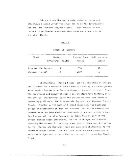
Table 4 shows the approximate number ot acres andstructures <strong>flood</strong>ed within the study I imits by the IntermediateRegional and Standard Project Floods. These figures do notreflect those <strong>flood</strong>ed areas and structures which are outsidethe study limits.TABLE 4EXTENT OFFLOODINGFloodNumber ofStructures FloodedFlooded Area(Acres)Flu i It-up Area(Acres)Intermediate Regional989042Standard Project121,33060Obstructions - During <strong>flood</strong>s, debris collecting at bridgesand culverts could decrease their carrying capacity and cause greaterwater depths (backwater effect) upstream of these structures. Sincethe occurrence and amount of debris are indeterminate factors, onlythe physical characteristics of the structures were considered inpreparing profi les of the Intermediate Regional and Standard ProjectFloods. Simi larly, the maps of <strong>flood</strong>ed areas show the backwatereffect on obstructive bridges and culverts, but do not reflect increasedwater surface elevation that could be causee by debris coi-Iect ing aga i nst the structures, or by depos it i on of s i It in thestream channel under structures. Of the 28 bridges and culvertscrossing the streams in the study area, most of them are obstructiveto the Intermediate Regional Flood and even more obstructive to theStandard Project Flood. Table 5 I ists water surface elevations atselected bridges and culverts that may be restrictive during <strong>flood</strong>flows.23