flood plain information south creek, north creek, catfish - Sarasota ...
flood plain information south creek, north creek, catfish - Sarasota ...
flood plain information south creek, north creek, catfish - Sarasota ...

You also want an ePaper? Increase the reach of your titles
YUMPU automatically turns print PDFs into web optimized ePapers that Google loves.
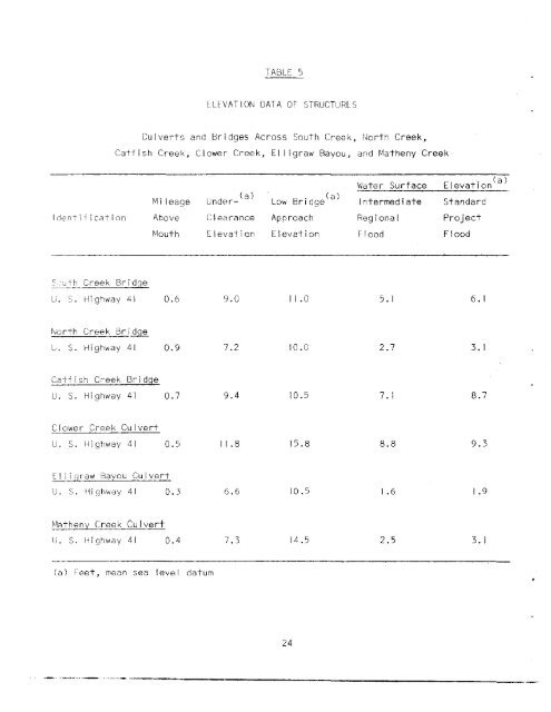
TABLE 5ELEVATION DATA OF STRUCTURESCulverts and Bridges Across South Creek, North Creek,Catfish Creek, Clower Creek, EI ligraw Bayou, and Matheny CreekWater Surface Elevation (a)Mi leage Under- (a) Low Bridge (a) Intermed i ate StandardIdentification Above Clearance Approach Regional ProjectMouth Elevation Elevation Flood FloodS'cth Creek BridgeU. S. Highway 41 0.6 9.0 11.0 5. I 6. INorth Creek Bri~L. S. Highway 41 0.9 7.2 10.0 2.7 3. ICatfish Creek BridgeU. S. Highway 41 0.7 9.4 10.5 7. I 8.7Clower Creek Cu IvertU. S. Hi ghway 41 0.5 11.8 15.8 8.8 9.3EI I i graw Bayou CulvertlI. S. Highway 41 0.3 6.6 10.5 1.6 1.9MCltheny Creek Cu Ivertu. S. Highway 41 0.4 7.3 14.5 2.5 3. I(a) Feet, mean sea level datum24