West Mojave Plan FEIR/S - Desert Managers Group
West Mojave Plan FEIR/S - Desert Managers Group
West Mojave Plan FEIR/S - Desert Managers Group

Create successful ePaper yourself
Turn your PDF publications into a flip-book with our unique Google optimized e-Paper software.
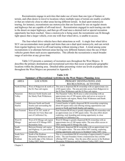
Recreationists engage in activities that make use of more than one type of feature orterrain, and often desire to travel to locations where multiple types of terrain are readily availableor that are relatively close to other areas having different terrain. In dual sport motorcycletouring, for instance, recreationists use motorcycles that are licensed for use on regular streetsand highways but are capable of off-road travel. Recreationists engaged in such touring can rideto the desert on major highways, and then go off-road once a desired trail or special recreationopportunity has been reached. Since a motorcycle is being used, the recreationist can fit throughtight spaces that a larger vehicle, even one with four-wheel drive, is unable to access.The four-wheel drive vehicles have their attractions as well. A single four wheel driveSUV can accommodate more people and items than can a dual sport motorcycle, and can switchfrom regular highway travel to off-road touring without missing a beat. A trend among somerecreationists is to alternate between areas having very different features since the use of theirvehicles grants them such access opportunities. This affords the recreationist a much broaderrange of activities at any given time.Table 3-52 presents a summary of recreation uses throughout the <strong>West</strong> <strong>Mojave</strong>. Itdescribes the primary destinations and recreational activities that occur at particular geographiclocations within the planning area. Detailed tables presenting visitor use levels at popular sitesthroughout the <strong>West</strong> <strong>Mojave</strong> are presented in Appendix T.Table 3-52Summary of Recreational Activities in the <strong>West</strong> <strong>Mojave</strong> <strong>Plan</strong>ning AreaAREA LOCATION PRIMARY DESTINATIONS ANDRECREATIONAL ACTIVITIESNorth El PasoPanamintValleyCentralSearlesEast Fremont<strong>West</strong> ElMirageSouthKramerSouth Newberry/Rodman<strong>West</strong> of Ridgecrest & north ofthe EL Paso sub region.Between North Searles andthe Manly Peak Wilderness.Between North and SouthSearles and surrounding thetown of Trona.<strong>West</strong> of US 395, north ofEdwards Air Force Base andeast of California City.<strong>West</strong> of El Mirage sub regionand west of El Mirage OHVRecreation Area.Between Kramer sub regionand Highway 15, just north ofVictorville.South of the RodmanMountains Wilderness and onthe north edge of the JohnsonValley OHV Area.Chapter 3 3-241This area is dispersed BLM ownership with an approximate sizeof 60 square miles. The area provides access from Ridgecrest tothe El Paso Wilderness and the El Paso sub region.The Panamint Valley BLM area is solid ownership with anapproximate size of 180 square miles and serves as access toNorth Searles sub region, Manly Peak Wilderness and DeathValley National Park.Central Searles is lightly dispersed BLM ownership comprisingabout 60 square miles and offering mining opportunities andaccess to North and South Searles sub regions.East Fremont BLM area is greatly dispersed BLM ownership withan approximate size of 200 square miles. The area offers desertexploring, rock hounding and mining opportunity in closeproximity to California City.<strong>West</strong> El Mirage is greatly dispersed BLM ownership with anapproximate size of 100 square miles. The area offers access toOHV touring and El Mirage Dry Lake.Moderately dispersed BLM ownership with an approximate sizeof 120 square miles. The area offers OHV touring, exploring,mining opportunity and access to Stoddard Valley OHV Area.This is a consolidated BLM ownership of approximately 8 squaremiles. The east boundary fronts a transmission line corridoroffering OHV touring. Also the area offers access to the RodmanMountains Wilderness and the Johnson Valley OHV Area.