Small Area Estimation of Poverty
Small Area Estimation of Poverty
Small Area Estimation of Poverty
- No tags were found...

You also want an ePaper? Increase the reach of your titles
YUMPU automatically turns print PDFs into web optimized ePapers that Google loves.
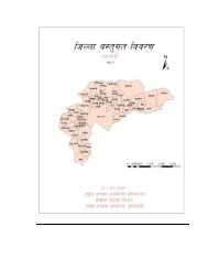
the VDC are calculated and added to the commonand comparable variable pool from which to select themodels. Even those variables that are incomparable onthe household level are comparable at higher levels,such as VDC, and could thus be added.As comparability <strong>of</strong> the survey and census variablesis a strong requirement for the small-area estimationmethodology to provide accurate results, this issue posesa challenge 8 . For the analysis in this report, we takethe conservative approach to limit the set <strong>of</strong> candidatevariables to those that are strictly comparable betweensurvey and census in the regions we are working with.Tables A2-A4 in Appendix I (<strong>of</strong> the main document)present the statistics for the variables that were selectedinto the three regional consumption models.3.3 Definition <strong>of</strong> “target area”Besides the five regions that are already introduced(East, Central, Midwest, West and Farwest), Nepalis divided into three ecological zones that run fromeast to west and that are defined by their altitude;Mountains, Hills, and Terai. Terai areas, or plains, arebelow 610 meters above sea level. They are generallythe most fertile and run alongside the southern border.The Hills are between 610 and 4,887 meters high, andinclude also Kathmandu and the touristic hotspot <strong>of</strong>Pokhara. Mountains are most sparsely populated andinclude all areas above 4,887 meters; obviously withmuch harder living conditions and lower levels <strong>of</strong>infrastructure. The country is divided into 75 districtsthat range in population between 5,819 (Manang) and1,688,131 (Kathmandu). The map in Figure 1 shows thedistrict boundaries and the three ecological belts in thecountry.Each district is divided into between 9 and 20 ilakas,which are collections <strong>of</strong> VDC’s and municipalitieswhich are respectively represented in the districtdevelopment committee. Ilaka’s are <strong>of</strong>ficiallyrecognized by the Ministry <strong>of</strong> Local Development. The2006 poverty maps are produced at the Ilaka level 9 .As indicated before, the Central Bureau <strong>of</strong> Statistics iswith technical support from the World Bank, making aneffort to produce small-area estimates at an as detailed aspossible level <strong>of</strong> geographic disaggregations. The mainFigure 1- Belts and district boundaries <strong>of</strong> Nepal7273TERAI6675686774HILLMOUNTAINTERAI65MOUNTAIN63706462694260615441715943554053 45583744HILL5752 46395638514750 49 4835353629302823272631 25 24 212034 3332 19181722121611MOUNTAIN13 107146159 185TERAI234World Bank 201 3 DECCTNational park8 . It is beyond the scope <strong>of</strong> this report to attempt to discover the cause <strong>of</strong> the disagreement between variables in the household survey and population census. But clearly this isan issue <strong>of</strong> concern.9. However, they redifined the original ilaka’s to be the rural part <strong>of</strong> existing ilaka’s only (927), and added each <strong>of</strong> the 58 urban municipalities as a new ilaka, resulting in a total<strong>of</strong> 976 new ilaka’s. For the ease <strong>of</strong> comparison, we adopt the same definition <strong>of</strong> ilaka in this report.NEPAL <strong>Small</strong> <strong>Area</strong> <strong>Estimation</strong> <strong>of</strong> <strong>Poverty</strong>, 2011, Summary and Major Findings 5