Small Area Estimation of Poverty
Small Area Estimation of Poverty
Small Area Estimation of Poverty
- No tags were found...

Create successful ePaper yourself
Turn your PDF publications into a flip-book with our unique Google optimized e-Paper software.
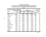
Executive SummaryNepal <strong>Small</strong> <strong>Area</strong> <strong>Estimation</strong> <strong>of</strong> <strong>Poverty</strong> 2011<strong>Small</strong> area estimates <strong>of</strong> poverty have become usefultool in targeting poverty reduction by geographicareas. By now, more than 60 countries have smallarea estimates <strong>of</strong> poverty (“poverty maps”). ForNepal, this is the second poverty map producedafter a gap <strong>of</strong> seven years in collaboration with theCentral Bureau <strong>of</strong> Statistics, Nepal. Visualized ongeographical map, small area estimates can conveyto audiences <strong>of</strong> all literacy levels the scale anddistribution <strong>of</strong> poverty not possible by tabular data.Further, poverty maps can be super-imposed onspatial variables such as climate or infrastructure toanalyze spatial determinants <strong>of</strong> poverty.<strong>Small</strong> area estimates improve the accuracy anddisaggregate spatially the poverty estimates madefrom survey data. The Nepal Living StandardsSurvey is representative at the level <strong>of</strong> 12 broadstrata, but district development committees inparticular value information at a lower level suchas the VDC, Municipalities – some 3970 <strong>of</strong> them.While the NLSS III includes too few observations toproduce estimates at district level or lower.The small area estimates in this report are basedmainly on most recent information from NepalLiving Standards Survey 2010-11 and Nepal Census2011. Auxiliary data sources include VDC-level GISinformation obtained from the Vulnerability Analysisand Mapping unit <strong>of</strong> World Food Program Nepal.Variables are: mean elevation in kilometers, meanslope in percentage, height range, standard deviation<strong>of</strong> height, population density in inhabitants per squarekilometer, distance to the district headquarters,length <strong>of</strong> road in kilometers (by ilaka), length <strong>of</strong>road in kilometers per thousand inhabitants (byilaka), length <strong>of</strong> rivers in kilometers. An improvedaccessibility measure called “Kosh” (measures howmany hours it takes for a normal person to walk fromthe VDC to the district headquarters) available withthe Election Commission was also used to enrich theestimates.Besides using more recent data and improvements inmethodology, the small area estimates in this reportremedy an important limitation <strong>of</strong> the poverty map<strong>of</strong> 2006 by providing estimates as close as the VDC/Municipality level. Though the previous poverty mapprovided estimates for 967 ilakas, for developmentplanning proposes, estimates at even finer geographiclevels would have been more useful. This exercise <strong>of</strong>small area estimation <strong>of</strong> poverty provides statisticallyreliable poverty measures for 2344 VDCs or groups <strong>of</strong>VDCs <strong>of</strong> Nepal. When statistical reliability is doubtfulto estimate VDC level poverty, similar VDCs have beencombined to generate reliable poverty estimates for theselect aggregate <strong>of</strong> similar VDCs inside a given ilaka.For all the VDCs, even for those precise estimates cannotbe made, confidence bands for poverty estimates areprovided..The main report presents 2010/11 small-area estimatesand maps for Nepal at the 75 district, 967 ilaka and 2344“target area” level, <strong>of</strong> poverty incidence, poverty gap,and poverty severity.The report also provides maps <strong>of</strong>the number <strong>of</strong> poor and their average consumption.However, this “Sumary and Major Findings” containsestimates <strong>of</strong> 75 districts and 976 ilakas. In addition,out <strong>of</strong> 2344 target areas, it includes the estimates <strong>of</strong> 58municipalities and VDCs having poverty incidencegreater than 50 percent.The findings confirm the spatial distribution <strong>of</strong> povertyin Nepal. <strong>Poverty</strong> - both as a rate and headcount - ishigh in the hilly areas <strong>of</strong> Far West and parts <strong>of</strong> Mid-West. The percentage <strong>of</strong> poor varies from negligible inparts <strong>of</strong> Kathmandu to 75 percent in parts <strong>of</strong> Gorkhadistrict. A comparison with the poverty map <strong>of</strong> 2006shows that though prosperity is spreading in Nepal,it has a hard time moving West and climbing Hills.<strong>Poverty</strong> concentration in the East and Central hasdeclined while it increased in the rest. Nearly halfthe small areas have poverty higher than the nationalaverage <strong>of</strong> 25.2 percent and contain two-thirds <strong>of</strong> thepoor in Nepal.v