

download PDF - Imaging Notes
download PDF - Imaging Notes
download PDF - Imaging Notes

Create successful ePaper yourself
Turn your PDF publications into a flip-book with our unique Google optimized e-Paper software.
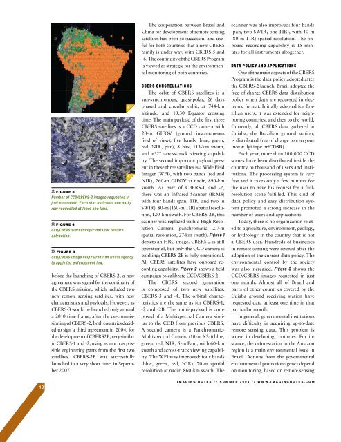
FIGURE 3FIGURE 4FIGURE 5before the launching of CBERS-2, a newagreement was signed for the continuity ofthe CBERS mission, which included twonew remote sensing satellites, with newcharacteristics and payloads. However, asCBERS-3 would be launched only arounda 2010 time frame, after the de-commissioningof CBERS-2, both countries decidedto sign a third agreement in 2004, forthe development of CBERS2B, very similarto CBERS-1 and -2, using as much as possibleengineering parts from the first twosatellites. CBERS-2B was successfullylaunched in a very short time, in September2007.The cooperation between Brazil andChina for development of remote sensingsatellites has been so successful and usefulfor both countries that a new CBERSfamily is under way, with CBERS-5 and-6. The continuity of the CBERS Programis viewed as strategic for the environmentalmonitoring of both countries.The orbit of CBERS satellites is asun-synchronous, quasi-polar, 26 daysphased and circular orbit, at 744-kmaltitude, and 10:30 Equator crossingtime. The main payload of the first threeCBERS satellites is a CCD camera with20-m GIFOV (ground instantaneousfield of view), five bands (blue, green,red, NIR, pan), 8 bits, 113-km swath,and ±32° across-track viewing capability.The second important payload presentin these three satellites is a Wide FieldImager (WFI), with two bands (red andNIR), 260-m GIFOV at nadir, 890-kmswath. As part of CBERS-1 and -2,there was an Infrared Scanner (IRMS)with four bands (pan, TIR, and two inSWIR), 80-m (160-m TIR) spatial resolution,120-km swath. For CBERS-2B, thisscanner was replaced with a High ResolutionCamera (panchromatic, 2.7-mspatial resolution, 27-km swath). depicts an HRC image. CBERS-2 is stilloperational, but only the CCD camera isworking; CBERS-2B is fully operational.All CBERS satellites have onboard recordingcapability. shows a fieldcampaign to calibrate CCD/CBERS-2.The CBERS second generationis composed of two new satellites:CBERS-3 and -4. The orbital characteristicsare the same as for CBERS-1,-2 and -2B. The multi-payload is composedof a Multispectral Camera similarto the CCD from previous CBERS.A second camera is a Panchromatic-Multispectral Camera (10-m XS-ñ blue,green, red, NIR, 5-m Pan), with 60-kmswath and across-track viewing capability.The WFI was improved: four bands(blue, green, red, NIR), 70-m spatialresolution at nadir, 860-km swath. Thescanner was also improved: four bands(pan, two SWIR, one TIR), with 40-m(80-m TIR) spatial resolution. The onboardrecording capability is 15 minutesfor all instruments altogether.One of the main aspects of the CBERSProgram is the data policy adopted afterthe CBERS-2 launch. Brazil adopted thefree-of-charge CBERS data distributionpolicy when data are requested in electronicformat. Initially adopted for Brazilianusers, it was extended for neighboringcountries, and then to the world.Currently, all CBERS data gathered atCuiaba, the Brazilian ground station,is distributed free of charge to everyone(www.dgi.inpe.br/CDSR).Each year, more than 100,000 CCDscenes have been distributed inside thecountry to thousand of users and institutions.The processing system is veryfast and it takes only a few minutes forthe user to have his request for a fullresolutionscene fulfilled. This kind ofdata policy and easy distribution systempromoted a strong increase in thenumber of users and applications.Today, there is no organization relatedto agriculture, environment, geology,or hydrology in the country that is nota CBERS user. Hundreds of businessesin remote sensing were opened after theadoption of the current data policy. Theenvironmental control by the societywas also increased. shows theCCD/CBERS images requested in justone month. Almost all of Brazil andparts of other countries covered by theCuiaba ground receiving station haverequested data at least one time in thatparticular month.In general, governmental institutionshave difficulty in acquiring up-to-dateremote sensing data. This problem isworse in developing countries. For instance,the deforestation in the Amazonregion is a main environmental issue inBrazil. Actions from the governmentalenvironmental protection agency dependon monitoring, based on remote sensing18IMAGING NOTES // S UMMER 2008 // WWW.IMAGINGNOTES.COM


