

Final Report A Comparison of Mobile Scanning to a Total Station ...
Final Report A Comparison of Mobile Scanning to a Total Station ...
Final Report A Comparison of Mobile Scanning to a Total Station ...

You also want an ePaper? Increase the reach of your titles
YUMPU automatically turns print PDFs into web optimized ePapers that Google loves.
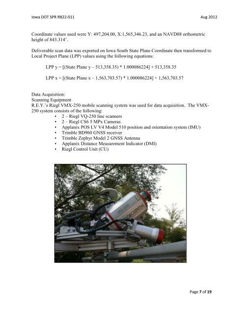
Iowa DOT SPR RB22-011 Aug 2012Coordinate values used were Y: 497,204.00, X:1,565,346.23, and an NAVD88 orthometricheight <strong>of</strong> 843.314’.Deliverable scan data was exported on Iowa South State Plane Coordinate then transformed <strong>to</strong>Local Project Plane (LPP) values using the following equations:LPP y = [(State Plane y – 513,358.35) * 1.000086224] + 513,358.35LPP x = [(State Plane x – 1,563,703.57) * 1.000086224] + 1,563,703.57Data Acquisition:<strong>Scanning</strong> EquipmentR.E.Y.’s Riegl VMX-250 mobile scanning system was used for data acquisition. The VMX-250 system consists <strong>of</strong> the following:• 2 – Riegl VQ-250 line scanners• 2 – Riegl CS6 5 MPx Cameras• Applanix POS LV V4 Model 510 position and orientation system (IMU)• Trimble BD960 GNSS receiver• Trimble Zephyr Model 2 GNSS Antenna• Applanix Distance Measurement Indica<strong>to</strong>r (DMI)• Riegl Control Unit (CU)Page 7 <strong>of</strong> 19


