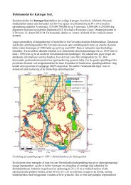
Automatic generation of elevation data over Danish landscape
Automatic generation of elevation data over Danish landscape
Automatic generation of elevation data over Danish landscape

Create successful ePaper yourself
Turn your PDF publications into a flip-book with our unique Google optimized e-Paper software.
References<br />
Hansen, M., Mølgaard, M. S. og Overby, S., Weje, P. N., (1995): Stråleudjævningsprogrammet BINGO –<br />
anvendt på statue. Aalborg Universitet, Landinspektøruddannelsen, 8. semester, Teknisk måling, Gruppe<br />
TM2 – Juni 1995.<br />
Haralick, R. M. and Shapiro, L. G. (1992): Computer and Robot Vision, volume 1, University <strong>of</strong> Washington,<br />
printed by Addison-Wesley Publishing Company.<br />
Heipke, C., (1996): Overview <strong>of</strong> image matching techniques, European Organization for experimental<br />
Photogrammetric Research, proceedings <strong>of</strong> the OEEPE- WORKSHOP on application <strong>of</strong> digital photogrammetric<br />
workstations, <strong>of</strong>ficial publication No 33, Lausanne, 1996, editor O. Kölbl, pp. 173 – 189.<br />
Heuchel, T. (2005): Experience in Applying Matching Techniques Using Images from Digital Cameras.<br />
Proceedings <strong>of</strong> the 50th Photogrammetric Week, Stuttgart. Dieter Fritsch (eds.). Wichman Verlag Heidelberg,<br />
pp. 181-188.<br />
Holm, M., Permes, E., Andersson, K., and Vuorela, A., (1995): A nation wide automatic satellite image<br />
registration system, SPIE Aerosense ´95, Conference on integrating Photogrammetric Techniques with<br />
scene analysis and machine vision II, Orlando, Florida, USA, 17 – 21 April 1995, SPIE vol. 2486 – 18, pp.<br />
156 – 167.<br />
Hyyppä, J., Hyyppä, H. and Ruppert, G., (2000): <strong>Automatic</strong> derivation <strong>of</strong> features related to forest stand<br />
attributes using laser scanner, International Archives <strong>of</strong> Photogrammetry and Remote Sensing. Vol.<br />
XXXIII, Part B3, Amsterdam 2000, pp. 421 - 428.<br />
Intergraph (1994): ImageStation Match-T (ISMT) User’s guide, appendix B: Mathematical Model for DTM<br />
Generation.<br />
Inpho GmbH, Stuttgart, (1994): Match-T, <strong>Automatic</strong> DEM Generation, User Manual, Version 1.3.1.<br />
Inpho Stuttgart, (1995): Match-T, <strong>Automatic</strong> DEM – Generation, Tutorial, Inpho Stuttgart, Photogrammetric<br />
Information Processing, Smaragdweg 1, D-70174 Stuttgart, Germany.<br />
Johansen, N. P., (1927): Danmarks Topografiska Kartläggning, Foredrag holdt i “Kartografiska Sällskapet”<br />
i Stockholm 7. marts 1927, Stockholm 1927, A. Börtzells Tryckeri A-B.<br />
Kleusberg, A. and Klaedtke, H-G., (1999): Accuracy assessment <strong>of</strong> a digital height model derived form<br />
airborne synthetic aperture radar measurements. Proceedings <strong>of</strong> the 47th Photogrammetric Week, Stuttgart.<br />
Fritsch/Spiller (eds.). Wichman Verlag Heidelberg, pp. 139-143.<br />
Kobrick, M., (2006): On the Toes <strong>of</strong> Giants – How SRTM was Born. Photogrammetric Engineering and<br />
Remote Sensing, March 2006, Volume 72, Number 3, pp 207-210.<br />
Kort- og Matrikelstyrelsen, (1989): Danmarks Geografiske Referencenet, Brugervejledning, Matrikelstyrelsen,<br />
Rentemestervej 8, (DK) 2400 København NV.<br />
Kort- og Matrikelstyrelsen, Geodæsidivisionen, (1992): Signalerings-Vejledning, Kort- og Matrikelstyrelsen,<br />
Rentemestervej 8, (DK) 2400 København NV.<br />
KMS, (2005): Forslag om etablering af en nøjagtig højdemodel <strong>over</strong> Danmark, note.<br />
Krarup, T., Kubik, K. and Juhl, J., (1980): Goetterdaemmerung <strong>over</strong> least squares adjustment. Int Arch<br />
Photogram XXIII, Part B3, Commission III, Proc. 14 th Congress <strong>of</strong> ISP, Hamburg, 1980, pp. 369-378.<br />
Kraus, K., (1990): Fernerkundung, Band 2, Auswertung photographischer und digitaler bilder, Institut für<br />
photogrammetrie und fernerkundung der Technischen Universität Wien, Ferd. Dümmlers verlag, Bonn.<br />
121