Automatic generation of elevation data over Danish landscape
Automatic generation of elevation data over Danish landscape
Automatic generation of elevation data over Danish landscape

Create successful ePaper yourself
Turn your PDF publications into a flip-book with our unique Google optimized e-Paper software.
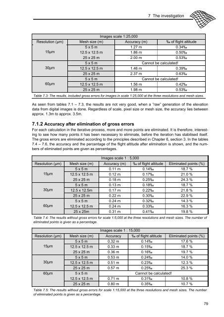
7 The investigation<br />
Images scale 1:25,000<br />
Resolution (μm) Mesh size (m) Accuracy (m) ‰ <strong>of</strong> flight altitude<br />
5 x 5 m 1.27 m 0.34‰<br />
15μm<br />
12.5 x 12.5 m 1.86 m 0.50‰<br />
25 x 25 m 2.00 m 0.53‰<br />
5 x 5 m Cannot be calculated!<br />
30μm<br />
12.5 x 12.5 m 1.46 m 0.39‰<br />
25 x 25 m 2.37 m 0.63‰<br />
5 x 5 m Cannot be calculated!<br />
60μm<br />
12.5 x 12.5 m 1.56 m 0.42‰<br />
25 x 25 m 1.98 m 0.53‰<br />
Table 7.3: The results, included gross errors for images in scale 1:25,000 at the three resolutions and mesh sizes.<br />
As seen from tables 7.1 – 7.3, the results are not very good, when a ”raw” <strong>generation</strong> <strong>of</strong> the <strong>elevation</strong><br />
<strong>data</strong> from digital images is done. Regardless <strong>of</strong> scale, pixel size or mesh size, the accuracy lies between<br />
approx. 1.3m to approx. 3.5m.<br />
7.1.2 Accuracy after elimination <strong>of</strong> gross errors<br />
For each calculation in the iterative process, more and more points are eliminated. It is therefore, interesting<br />
to see how many points it has been necessary to eliminate, before the iteration has stabilised itself.<br />
The gross errors are eliminated according to the principles described in Chapter 6, section 3. In the tables<br />
7.4 – 7.6, the accuracy and the percentage <strong>of</strong> the flight altitude after elimination is shown, and the numbers<br />
<strong>of</strong> eliminated points are given as percentages.<br />
Images scale 1 : 5,000<br />
Resolution (μm) Mesh size (m) Accuracy (m) ‰ <strong>of</strong> flight altitude Eliminated points (%)<br />
5 x 5 m 0.11 m 0.14‰ 18.7 %<br />
15μm 12.5 x 12.5 m 0.12 m 0.17‰ 21.0 %<br />
25 x 25 m 0.18 m 0.25‰ 24.3 %<br />
5 x 5 m 0.13 m 0.18‰ 18.7 %<br />
30μm 12.5 x 12.5m 0.17 m 0.22‰ 21.8 %<br />
25 x 25 m 0.22 m 0.30‰ 22.9 %<br />
5 x 5 m 0.24 m 0.32‰ 14.3 %<br />
60μm 12.5 x 12.5 m 0.24 m 0.33‰ 16.3 %<br />
25 x 25m 0.31 m 0.41‰ 19.8 %<br />
Table 7.4: The results without gross errors for scale 1:5,000 at the three resolutions and mesh sizes. The number <strong>of</strong><br />
eliminated points is given as a percentage.<br />
Images scale 1 : 15,000<br />
Resolution (μm) Mesh size (m) Accuracy ‰ <strong>of</strong> flight altitude Eliminated points (%)<br />
5 x 5 m 0.32 m 0.14‰ 17.6 %<br />
15μm 12.5 x 12.5 m 0.33 m 0.15‰ 18.7 %<br />
25 x 25 m 0.36 m 0.16‰ 19.7 %<br />
5 x 5 m 0.53 m 0.24‰ 14.0 %<br />
30μm 12.5 x 12.5 m 0.51 m 0.23‰ 12.3 %<br />
25 x 25 m 0.57 m 0.25‰ 25.3 %<br />
60μm<br />
5 x 5 m Cannot be calculated!<br />
12.5 x 12.5 m 0.71 m 0.31‰ 10.8 %<br />
25 x 25 m 0.80 m 0.35‰ 10.7 %<br />
Table 7.5: The results without gross errors for scale 1:15,000 at the three resolutions and mesh sizes. The number<br />
<strong>of</strong> eliminated points is given as a percentage.<br />
79